The position of the marker is approximate, based on the notes below. Please let us know if you can add any information about the bridge's name, location, and when it was built / demolished.
Here are the notes about it so far:
Chinarail remembers the bridge was just off the old road between Taipo and Fanling, and reputed to be at least three hundred years old.
Lawrence Tsui replied:
I would speculate that it could be a path at Kau Long Hang near Wo Hop Shek, to On Lok Cheun & Shung Him Tong Village (formerly Tsung Pak Long) to the old walled villages of Ma Wat Wai & Lo Wai, to Po Kut Tsai (Queen's Hill) to Lau Sui Heung and Sha Tau Kok and Shenzhen. The Lung Yeuk Tau Heritage Trail should be part of this ancient path.
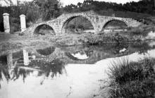
Based on the photo from IDJ,

Phil added:
IDJ's picture gives a clearer background that has - coupled with Lawrence's comments about Kau Lung Hang and Wo Hop Shek - meant I have found a match for the ridgeline at the back. Unfortunately the exact position isn't known and modern development means there is no longer a decent line of sight all round, however, the small river that leads off from the opposite side of the road of Wo Hop Shek seems likely. The area is now dominated by the Jockey Club Road flyover, but the ridgeline at the back is definitely Wo Hop Shek.
The high rises now blocking the view are Dawning Views and Avon Park.
I asked Guy Shirra for help, and he introduced Ruy Barretto, who writes:
This bridge was not in Taipo.
My recollection is that It was on the right as one goes north before you entered Fanling. You could see it from the road. Wo Hop Shek would be on your left as you drove past.
Further on, as you approached Fanling Roundabout/Crossroads, there was an area of nice houses and little canals. Called On Lok Tsuen, I think, which fringed the Sha Tau Kok Road near Luen Wo Hui.
The whole area became messed up, and the river polluted. The bridge may have been demolished as part of drainage works. Maybe the foundations can be found somewhere.....
I think it featured in books and so on. Suggest to look around more.
Photos that show this Place
Comments
Stone Bridge
David
This earlier image already on Gwulo needs to be linked with the others related to this subject
https://gwulo.com/media/20340
Thanks IDJ, I've just added
Thanks IDJ, I've just added the Place to the photo so they're connected now.
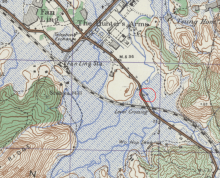
Bridge on map
On the 1945 map of the Fanling area there is a bridge shown in the general location of where the photo may have been taken, I have circles it in red. The map also shows the location of the Hunters Arms in Fanling. All can be seen on my site http://www.hkmaps.hk/
Thanks Tymon, that location
Thanks Tymon, that location matches Ruy Barretto's memories quoted above:
My recollection is that It was on the right as one goes north before you entered Fanling. You could see it from the road. Wo Hop Shek would be on your left as you drove past.
I'll move the marker.
There's a modern bridge close to that location, but the area looks very different. Here's the view from bridge now:
Location of the Bridge
Tymon is the map expert but I am thinking that there must have been a sustantial bridge across the river nearby leading from Wo Hop Shek to the path between Kau Lung Hang and Fanling: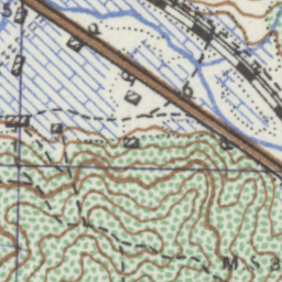 And the modern map still shows a path:

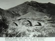
1958 Image of the Old Stone Bridge
Viewed an image of the old stone bridge at Fanling and hills in the background in the 1958 Directory of the Department of Commerce and Industry at https://digitalrepository.lib.hku.hk/catalog/f4758j081#?c=&m=&s=&cv=47&xywh=-690%2C1045%2C3463%2C1395 (Scroll to Image 48)
Stone Bridge
You can see on aerial images from the early 80s that the current modern bridge was built next (immediately south) to the old stone one. SO the two co-existed for a few years until what looks to be the removal of the old bridge sometime around 83/84.