View the original, larger copy of this image at the UWM website: http://collections.lib.uwm.edu/u?/agsphoto,16562
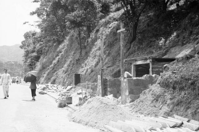
I think this is Queen's Road East between Kennedy and Stubbs Roads with an air raid shelter being constructed under Mount Parish. See here
The lower hill in the distance looks like Leighton Hill with the government quarters on top. Any other views are welcome.
Date picture taken
1941
Gallery
Comments
The hill in the background
The hill in the background doesn't look like Leighton Hill to me.
Could it be one of the tunnels along Blue Pool Road?
Regards, David
Re: Photo
Just going by first impressions. If it was Blue Pool Road, I think the gradient of the road would have been steeper.
Re Photo
Hi there,
Likely somewhere on Kennedy Road. The portal shown is a bit indented, might be just around the stairs up to Sbiu Fai Terrace. I'll seeif I could go check itout next week.
Best Regards,
T
Harrison Forman Collection
I recall there are a few other camera angles and views on this particular piece of construction in the Harrison Forman collection - might be a few more clues there.
I didn't reach any conclusion on the location though myself when I last looked.
Agreed, not likely to be Blue
Agreed, not likely to be Blue Pool road - the background to that should be Happy Valley, not hills like these. Hopefully some of the other angles will help.
Regards, David
Another View
I will keep on adding photos of the air raid shelter onto this page until a positive identification is made. See here
Re: Kennedy Road?
Hi there,
I have drawn a straight line along the straight section of Kennedy Road towards Kowloon in Google Earth and the straight line crossed the ridge just about the Lion Rock, towards its waist.
Lining it up would require going up Bowan Road or even in Wanchai Gap as it is impossible to see the ridge from Kennedy Road anymore owing to the tall buildings.
If they match, it would very likely be Kennedy Road.
Best Regards,
T
re tunnel portal
am in Queens Road East camp - same view today you'd see Leighton Hill, where the flats now block the view of the hills behind
The electrical/ telecom junction box clue?
Does the junction box and telegraph poles give us a clue?
If you look at the other pics from the HF collection a similar box can be spotted (see below) on the QRE/ Hennessy Road intersection picture.
So I am thinking maybe the hillside opposite Ruttonjee/ Wanchai Park on QRE.
Re: Queen's Road East"
Hi there,
The gradient of that short section of Queen's Road East along the Northern slopes of Mount Parish does not match the photo above. It's an uphill before reaching Ruttongee and downhill right after that. It is not as straght and long as shown in the photo too.
I would propose it is unlikely for Queen's Road East.
Best Regards,
T
Re: Queen's Road East
I am in the Queen's Road East camp. :)
If I remember correctly, that stretch of the road is rather flat and not too much of a downhill. Kennedy Road just south of Queen's Road East is more of an uphill slope.
Just my two cents as an alumnus of Wah Yan.
Re: Probably not Wanchai at all
Hi there,
I had been walking along Black's Link, Wanchai Gap, Bowen Road, Kennedy Road and lastly, Queen's Road East, trying to line up the view. I have to admit, things did not add up. The hill in the back is simply too close to be across the harbour. The closer and lower ridge could not be identified.
No clues about that electric or whatever utility box as shown as well.
Best Regards.
T
Re: Not Wanchai
My initial impression was looking eastbound on Queen's Road East towards Happy Valley and Leighton Hill. Agree that one is not looking across the harbour.
Re: Not Wanchai
Here?
http://maps.google.com.hk/maps?q=wah+yan+college+hong+kong&ll=22.275118…
There was a landslide at the corner of Queen's Road East and Stubb's Road in the early 1990s, causing the slope to be reconstructed or reinforced. I am not sure if there were portals on that slope though.
Re: Not Wanchai
Hi there,
After my site visit yesterday, I believe the curve and gradient of the road shown in the photo and that section of Queen's Road East as well as Kennedy Road did not add up.
Basically the slopes under WYCHK had been reconstructed since the 1970's various times. As far as I could recall the most severe landslides happened in the early 1970's where a section of the drive way between the lower & upper car park of WYCHK gave way, which coincide with the Kotewall/Po Shan Road disaster.
Best Regards,
T
Re: The Utility Box
Hi there,
The Utility box looked more or less the same as the one outside DGS before it was removed. Maybe it's only me, but I do not recall seeing similar utility boxes in Wanchai when I was a kid. I wonder if HK Electric used the same utililty box as CLP did. If they were present before WWII, I guess they had alread been replaced in the 1950's or 1960's.
Best Regards,
T
That's could be......
Hello folk,
This photo suggests a similar geography in my memory
In the 1960s, I sometimes chose to walk to school from Central District, along Queens Rd, passing Wan Tsai, just near the beginning of Queen's Rd E, turning hillside onto Stubbs Rd. Here I saw the North side of the Happy Valley Race Track, and the smaller Caroline Hill with huge hill as its background.
At this section of the Queen's Rd, it bends around the hillside, also rises up very gently and then goes down again, soon leaving Wan Tsai behind and entering the Happy Valley region.
Then in 1970 commercial office towers appeared in the area. One of them, as I could remember was the AIA Insurance Co., right by the foot of Stubbs Rd. It should be blocked off by the hillside, maybe!
Am I right?
Regards
Tung
Harrison Forman photos
Been looking at the digital ID numbers of Forman's collection. It shows a photo sequence of the places that he visited. The above photo was taken in walking distance of the ARP Headquaters, Morrison Hill Road and the Bowrington Canal air raid shelters..