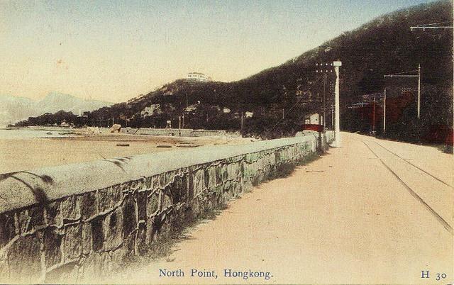
Here's view of the tram line you don't see any more - green hills to the right, and beach to the left! Can anyone identify any of the (few) landmarks shown to give an exact position?
Also, do you know when the tram line was extended past Causeway Bay, to narrow down the date? The HK Tramways website just says:
1903: The construction of a single-track system began and it ran from Kennedy Town to Causeway Bay. The route was later extended to Shau Kei Wan.
I'm not sure if that "later" means before or after the trams started running the following year.
Source: This image came from Flickr, see https://flickr.com/photo.gne?id=4229597190
Date picture taken
1910s
Gallery
Shows place(s)

Comments
Re: Tramline
The info on the Tramways website is not entirely correct.
The tramline east of Arsenal St to Shaukiwan was opened on 30 July 1904 whilst the remaining portion to Kennedy Town was opened two weeks later.
In a nutshell, the tramline from Kennedy Town to Causeway Bay was mainly a double line (with single lines in places) whilst that portion from Causeway Bay to Shaukiwan was a single line. I am not sure when the line to Shaukiwan became a double line.
From July 30 1904
Similar photo
Found this one on Flickr:
At first, both look the same. But a closer look reveal differences: on the one posted by eternal1966, there is an empty lot below the building on the ridge where houses are visible on the one by Cairlinn. Probably eternal's is older.