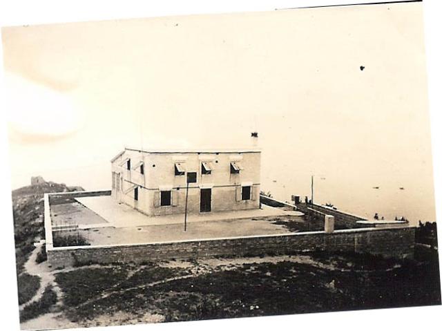
Photo courtesy of Laura Ziegler Darnell.
Probably taken from House #30, just up the slope from #29.
Date picture taken
1940s
Gallery
Shows place(s)
Photo courtesy of Laura Ziegler Darnell.
Probably taken from House #30, just up the slope from #29.
Comments
House # 29, Cheung Chau Island
My mother and 8 children, ages from one, (me) to 14, moved to the Island in 1938, while our father (Rev. Ziegler) was a Missionary in the China interior. It was considerd unsafe for families at that location and we had to flee for our lives from Hankow at Christmastime 1937 because of the Japanese invasion there. Father would get a months leave each summer to visit Cheung Chau. At first we rented house #6 and a few months later moved to house #29. These were some of the happiest years of our children's life. We had a swimming beach and the whole Island to explore. My older siblings were involved in the mine incidents and the whale washing up on the beach that smelled so bad.We left right before Hong Kong fell and wound up in Stanley Internment Camp.
On the Island, I recall having a well and a servant pulling out a poisinous snake and throwing it at us and laughing at us when we were frightened. There was a porch on one side of this house and so much of our activites happened on this porch. We have pictures of us all climbing up on the roof of this house.
I recall looking down toward town for the typhoon flags and securing the storm windows before a typhoon hit. I suppose a different color meant a different strength of storm? I don't know for sure.
Last November David Bellis and Donald Ady and I tried to find this house, but were not successful. We think it is or was just below the present Meteorological Station. I would dearly love to answer this question. It is a mystery I just NEED to know!! If anyone has any information at all about this house, I would be very grateful to hear from them.
Rgards,
Laura
Re House 29
Hi there,
I looked up Cheung Chau aeronautical meteorological station and got his piece of history from the Observatory:
http://www.hko.gov.hk/wservice/tsheet/pms/his_cch_station_e.htm
It moved to the current location in the 1970's. There is a photo in that link showing a distintive rock formation in the background, which also present in the original House #29 photo. I believe House #29 is already gone since the station moved there. However part of the foundation and retaining wall could still be seen in the photo.
Laura,
If you are in town I guess it would worth contacting the HK Observatory and see if they could consider granting a site visit for old time's sake.
Best Regards,
T
well spotted Thomas
I think Thomas is right, the rock formation is the same. I suspect the ruins you can see is the outer wall of the garden though.
Re: House #29
Hi Phil,
Just tried the GeoInfo Map service site and found there is a rectangle a bit down the spur from the Station. Thus the foundation is still there alright.
http://www1.map.gov.hk/gih3/view/index.jsp
Zoom in down to street and all is shown. Also checked the 1:10,000 map search at Hong Kong Map Service. Foot paths are also shown around the area despite much over growned. It also showed there are some graves in the neighbourhood.
Best Regards,
T
仙人井 "Immortals / Fairy Well"
in the GeoInfo Map, just north east of the weather station is a tag "仙人井". Perhaps this is the well that Laura spoke of.
re: 仙人井 "Immortals / Fairy Well"
I hadn't noticed that - well spotted. It's certainly close enough to Laura's house.
Regards, David
Matching rocks?
Here's a photo taken in 1986, where the rocks in the background look like the rocks in the top-left corner of the older photo above.
Behind the base of the right-hand red & white antenna there's a low wall. Could that be the same wall shown in the old photo?
Regards, David
The Sin Yan Tseng region of Cheung Chau
The region Sin Yan Tseng of 1950s Cheung Chau was landmarked by the Radar Station near the peak , House #27 and #27A, maybe #28 (?) and #29 ( site only) scattered nearby south of the Peak Road West. There were also a village of dozen plus families called The Papaya Garden below the north side of House #27. The rest of the area was quite undeveloped as seen in many photos of the same time.
The name Sin Yan Tseng means exactly The Fairy's Well. Sin Yan are the Fairy or Fairies. Remember Taoism has been a very popular religion among the common folks. It allows people to believe in Fairies who looked after the good people's needs. They appeared as a human , as being told, in old time costumes and always prepared to help good people and punish the evil ones. Sin Yan Tseng wound be the well that held the wonderful water used by the Fairies. I believe it was very unlikely the existence of such a well in the area. A name always being picked out of well meaning but not of reality. Just like there never a Queen live on Queen's Street. Get it?
Ding!
Tung
PS Of course there were many wells all over the Cheung Chau island as there was no reservoir on the island nor water supply from Lantau before the late 1950s. Wells were common and usually the people employed the Feng Shui master to locate the spot for the well before digging up. With a well of good water supply, people's living would improve for better.
CC NDB & Weather Station near Mystery Rocks group
This is quite a typical view as seen by airplane pilots as they flew passing the two CC NDB aerial towers which are painted like the barber's pole of in red and white, in the good old days of 1950s to early 70s . The one beyond seemed to be standing near the base wall of the previous House #29.
The typhoon signal mask stands in the yard of the building (Now emptied) . Here the background of the mask falls on the Laura's Mystery Rock Group. One can tell the rock formation was right at the cliff. There is a path way or trail on the right from the Peak Road and maybe still available today. But better to have some locals to lead the way if you want to visit there.
Not to far beyond the House #29 site, there is a geographical fault line running across the entire headland. A concealed cave or underground passage is formed near the sea level. But is not sure of its condition now!
Want some exploration there?
Good luck.
Tung
The water in the left is Nam Tam Wan of the Sen Yan Tseng area and the right is off the Kau Kwoon Tong area.
water supply to Cheung Chau, 1955
As about good water supply. This is a continuation of this living condition shared by Tung Lin on Oct. 12 (here).
Read an incident of turbid water supply in Cheung Chau as covered in old Chinese newspaper. Hence, could backtrack to the origin of Cheung Chau tap water supply
at first. In 1955 :
The newspaper reports this incident in 1956 :
In recent two months, users found that tap water contains impurities and very turbid.
Firstly, it was thought that the filters and pumps are not okay...
Higher grade officers and technicians were sent to the service reservoir (i.e. Cheung Chau Tai Kwai Wan~ peak reservoir) to install a new pipe to lead water on the surface of the reservoir out for residents' use and block the original underground pipe. That task was completed the day before ... now every household user is satisfied, only that the water flow is slower than before.
All considered that it was because that place was a 'mud hill'... hence caused such issue.
(excerpt only)
This way of water supply to Cheung Chau seems to last until early 1970s.
The said service reservoir was on northern part of Cheung Chau, which is not covered in the 1938 map on gwulo.
sources
1. PWD Annual Report 1955
2 Wah Kiu Yat Pao, 1956-8-4
3. wikipedia
(+) the counterpart on Lantau Island is called Shap Long Reservoir
(~) Tai Kwai Wan was euphemized to a good-to-hear name (大貴灣 in Chinese) in later time
p.s. it looks like some houses still remain in Admiralty Lot 12 as the 1945 aerial photo, even if House #29 may be just ruins by then (link)