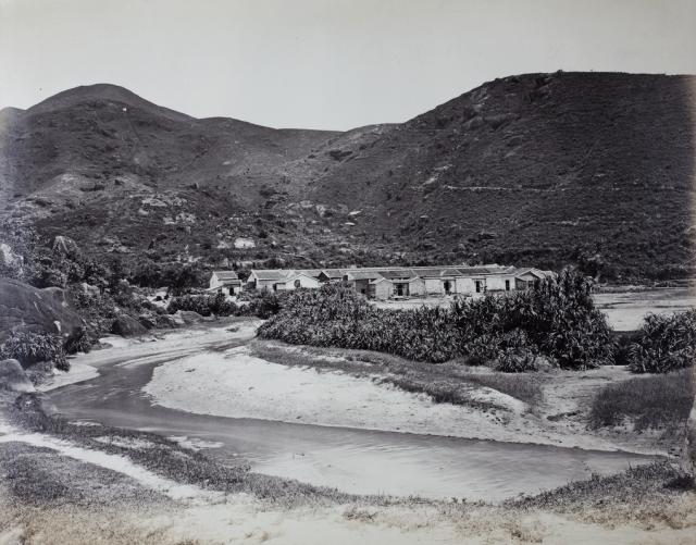
Originally thought to show Wong Nai Chung Village, Happy Valley, Hong Kong Island, c.1870-75 (Photo on Flickr).
A discussion (see comments below) showed that this is Tai Hang Village. The photo was re-uploaded (without a watermark) from the University of Bristol: A Chinese village, East Point, Hong Kong | Historical Photographs of China. The photo is by W.P.Floyd and dated to 1868.
Date picture taken
1868
Gallery
Shows place(s)
Comments
This should be Tai Hang.A…
The text is a good read.
But the photo is Tai Hang.
A view of Wun Sha Street: https://gwulo.com/media/33356
Tai Hang or Wong Nai Chung
Hi TN. I'm a bit confused as to decide which village is shown in the photo. A quick check on the internet showed that one half says Tai Hang (e.g. Facebook), and the other half says Wong Nai Chung (e.g. The Story of Happy Valley, from Swamp to Racetrack to Community).
The (likely) original photo (taken by William Pryor Floyd c.1868) can be found here: A Chinese village, East Point, Hong Kong | Historical Photographs of China. Unfortunately, East Point is a bit vague.
Re: Tai Hang or Wong Nai Chung
Given the hills in the background, I think TN has got Tai Hang correct. East Point would normally refer to Causeway Bay and the area south of the causeway, in this case Tai Hang. The racecourse was built in 1848. If Floyd had taken the photo, he would have likely made reference to Wong Nai Chung or Happy Valley.
River
The foreground looks to be a river?
1845 Ordnance Map
On this site the picture is shown as 'Wong Nai Chung village in the 1870s'.
And the 1845 Ordnance map is shown, both Wong Nai Chung and Tai Hang have a river flowing past them.
The river in the picture has a definite curve to it.
Does the cluster of houses in the photo seem more like the Wong Nai Chung cluster on the map?
And is there a very early Broadwood Road there (on the map)?
https://gwulo.com/media/13540
https://gwulo.com/media/13540
https://gwulo.com/media/41117
Tai Hang!
Dear all. Thank you for discussing the location of the village shown. It seems that there are two places favored on the internet. However, the comparison at https://gwulo.com/media/41117 shows that Tai Hang is correct. I will change the post accordingly.
It would likely be of interest to create a place on Gwulo. I should be approximately between (today's) Concord Villa and Haw Par Mansion. Any suggestions?
Addendum
Just found Historical Building Appraisal_753 about Nos. 30 and 31 Sun Chun Street. It is said there: The premises at Nos. 30 & 31 Sun Chun Street (新村街) were built after 1894 by the Wong family. Sun Chun Street literally means “New Village Street.” A map dated 1901 shows that the houses were situated in an old village named Tai Hang Village which was on the southwestern bank of a stream.
Re: Tai Hang
Hi Klaus,
I believe the marker should be somewhere along To Lo Wan Road instead, considering threr are still two very old village houses in situ and still in used in Sun Chun Street.
I was considering when the photographer was standing though.
T
Tai Hang Village
The 1897 map on New HK Maps shows (similar to the 1901 map on Gwulo) an old village labelled Tai Hang Village. The newer houses north-west of the older ones are shown only as dotted lines, likely just planned and not yet constructed.
On the map, the old village has houses in four rows. When looking at the photo, four rows can also be distinguished. This would mean that the old village was south-east of Sun Chun Street, north-west of today's Illumination Terrace.
Addendum
The 1889 map shows the same houses labeled Tai Hang Tsun.
Tai Hang Village
The modern map shows two Sun Chun Streets, parallel to each other. If we put a marker just left of the junction of the southern Sun Chun Street and Ormsby Street, that looks about right for the location of the old village: https://gwulo.com/map-of-places#18~22.27835~114.19246~Map_by_GovHK-Markers-1901_HK~50
Maybe also worth noting that the marker's location shows the site of the 19th century village, as after the land to the north was reclaimed and built on, later maps use 'Tai Hang Village' to describe the larger area up to Tung Lo Wan Road.
Re: Sun Chun Street
Hi David,
I suspect San Chun Street may be a loop around the houses. The numbering is also a bit odd to me.
T
Naming of Broadwood Road
In reply to Aldi's question re "early Broadwood Road", Broadwood Road wasn't named until 1915, but there was a road: