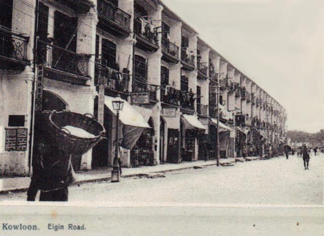
On Flickr attributed to the 1920s, but Elgin Road became Haiphong Road already in 1909. Possibly taken from Robinson/Nathan Road.
There is a gas lamp in front of the houses. Public Works Report for 1892 states the erection of gas lamps on this road.
Source: This image came from Flickr, see https://flickr.com/photo.gne?id=30224965842
Date picture taken
1900s
Gallery
Shows place(s)

Comments
1900s Elgin/Haiphong Road
long row of houses
It looks as if we can see the same long row of houses on Elgin/Haiphong Road on both photos. These houses should be the block visible at K.I.L. 213 on the 1896 map. And the photographer wasn't as far away as Nathan Road but near the Kowloon Hotel.
Update:taken still more to the west near Canton Road.
1900s Elgin Road - puzzle??
If the 1900s Elgin Road photo was taken close to the then Kowloon Hotel, the far background of the row of houses should be the wharves. But it looks quite similar to that shown in the other photo, which is the then Robinson Road. What's wrong?
Re: Main Postcard
The signboards are too blurry for me to read.
If the trees (?) in the distance in the main postcard represent those on Nathan Road, it may mean that the postcard needs to be horizontally flipped to show the correct orientation ?
Main postcard mirror inverted
Moddsey, I followed your proposal and flipped the postcard.
If the mirror inverted photo would be correct, we would look east starting with low house numbers (about no. 5-10). At the end of the three-storey buildings row, one would expect to see the Queen's Hotel / Occidental Hotel / Royal George Hotel / Palace Hotel [1901-c.1945] as visible on the photo 1900s Elgin/Haiphong Road. But it is missing.
Therefore I think the postcard photo is correct and not inverted, and we are looking west towards Canton Road .
Additionally, I think that the sign reads something like "??CHEONG", the letters on the flipped photo don't look to be correct.
Not flipped
The photo as posted originally is not flipped. On the left most vertical sign, I can read only one word down near the bottom, '家' , and it is not flipped, showing the photo is oriented in the correct way.
Re: Not Flipped
Thank you both for the comments.
If it is not flipped, then one is looking west and seawards towards Canton Road and the open area in between the Kowloon Wharf and Godowns at the junction.
Thus, I cannot account for what can be seen in the distance at the western end of Haiphong Road. Something to work on as photos of the Haiphong/Canton (MacDonnell) Road junction are hard to come by.
(Update: Original postcard by Sternberg. Another photo postcard below and at Hong Kong Memory with description here One may be looking at a cluster of trees at the junction of Haiphong and Canton Roads)
Re: Hong Kong Memory Postcard
I also found the photo, but I was unsure if the description would be correct. What puzzled me is the block of four-storey buildings on the right. I these were on Elgin/Haiphong Road, they needed to have three-storeys. Any ideas?
Re: Four-Storey Building at Junction
Not sure yet if the four-storey building was on the northern side of Haiphong Road at the junction with Canton Road. See 1927 aerial photo of TST. There may have been another building in front of the four-storey building in later years.
Yes, the description at Hong Kong Memory needs to be confirmed as views of the western section of Haiphong Road are hard to find.