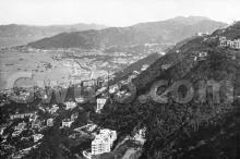
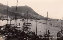
This reclamation in the 1920s pushed the Wanchai coastline from Praya East (today's Johnston Road) out to Gloucester Road.
We can follow its progress in the annual reports of the Public Works Department.
Work began in 1921, though the major work didn't get going until the following year. Here's the description in the report for 1921:
Praya East Reclamation Scheme
130. Contribution by Government towards Fund for Reclamation - As mentioned in paragraph 171 of last year's Report, those persons entitled to participate in the Scheme accepted it under the conditions laid down by Government at a meeting held on the 4th May, 1920. An Ordinance (No.17 of 1921) authorizing the Government to carry out the works was introduced on the 9th September, 1921, and a contract was awarded to Messrs. Sang Lee & Co., [...]
The Contract Documents were signed on the 20th October and notice was given on the 1st November to commence the works, the Contract time for completion being 6 years. From then to the close of the year operations were confined to the erection of offices for the Assistant ENgineers and Overseers, workshops and coolie quarters, construction of the transport track along Bowrington Canal and the construction of Guide-pile Stagings on the line of the Sea Wall.
[...]
The completion is noted in the report for 1929:
166. Praya East Reclamation:
[...]
(a) Filling. - The filling in of the reclamation was completed on the 31st May. The quantity of filling material deposited in the reclamation during the year amounted to 17,939 cube yards, making a total of 3,111,099 cube yards, of this total 2,906,120 cube yards was paid as filling from Morrison Hill, the balance (204,979 cube yards) was from other sources, the greater portion coming from East Point Hill. The total area of land formed was 90 acres, of which, about 3 acres was formed during the year.


Comments
Moddsey has found this map of
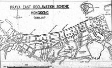
Moddsey has found this map of the planned reclamation:
Most of the finished reclamation looks very similar to this plan, though Tonnochy Road is an exception.
On the plan it runs south across the land that was the old Morrison Hill, ending at Happy Valley. Morrison Hill proved much harder to excavate than expected, so the planned roads in that area were never built.
Today the southern end of Tonnochy Road is at the junction of Hennessy Road. But look south across the junction and you can see where it was planned to continue. That unused section of the road extends as far as Wanchai Road, and is now used as a public basketball court ('Hennessy Road Playground').
Problem solved
Thank you..The map solved the problem why there is a basketball court below Wanchai Road.
As a child living in Wanchai,I always asked this question,The answer always heard was that the houses at that place were destroyed by the Allies bombing during World War Two, as no landlords of the houses can be found, the Government used that place as a basketball court for those living in Wanchai.
Map of the Area
Re: Basketball court. Further information here
Report
A report from 1931 of the reclamation (PRAYA EAST RECLAMATION SCHEME. FINAL REPORT) can be found here.
basketball court
Dear Raymond:
There is a bit of history for that basketball court. It was next to a funeral home from 1930s to 1966 before it moved to North Point. It was in operation for another year.
https://gwulo.com/node/56417#17~22.27790~114.17836~Map_by_GovHK-Markers…
After that it had been empty for 7 years. In 1974, government opened the basketball court there. According to a newspaper, it was a deserted government land before the court was opened. It may be understandable as it may be hard to sell as it was associated with bad luck according to Chinese tradition. By the way, its address is 216 Wanchai road on today's Google map but has no number in a 1957 map found on gwulo.
http://the-sun.on.cc/channels/adult/20070211/20070210222329_0000.html
https://www.sksmokkng.co/%E7%81%A3%E4%BB%94%E6%AE%AF%E5%84%80%E9%A4%A8/
https://mmis.hkpl.gov.hk/coverpage/-/coverpage/view?_coverpage_WAR_mmis…
basketball court
A news report on 1974-6-18 indicates the land was a deserted government land before a basketball court was built there in 1974.
=====================================
It has been used as a parking lot for trucks around 1963 . In this areal map in 1963, one can see the trucks parked there (labelled C). There are stairs going down from Wanchai rd to Hennessey rd on the right side of that truckyard. On the left near Hennessey rd, there was supposed to be a petrol station (hard to find in the map) as seen in this 1958 picture.
https://gwulo.com/media/35760
This 1965 map c0ntains a lot of information around the hennessy-tonnochy junction with the following clearly labelled:
1. two petrol stations
2. Hong Kong funeral home
3. Even the stairs going down from Wanchai road.
The East Praya Reclamation…
The East Praya Reclamation Scheme may have taken place in the 1920s but the proposition of the scheme to the Hong Kong Government and Marine Lot Holders by Sir Paul Chater occurred as far back as early 1903.
Source: The China Mail, page 2, 21st May 1903