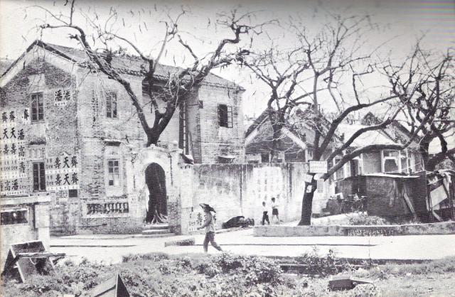
Pete Spurrier (https://www.blacksmithbooks.com/) has kindly sent me this image from an old guide book he has. He'd asked me to identify the location some years ago and it was clear to me it showed Sha Tau Kok Rd by On Lok Tsuen in Fanling.
Image is from - The Golden Guide to Hongkong and Macao by P. H. M. Jones (1969) with the caption 'Domestic architecture, Fanling'.
The main building on the left is Sui Sing Shu Sut, and next to it is the Hin Yuen Ancestral Hall.
At the bottom left of the image you can see the corner of the perimeter wall for what was Lai Yue Hing Tong (aka Fanling Babies Home).
Here is a modern day comparison of the view courtesy of Streetview.
Date picture taken
1969 (year is approximate)

Comments
Great find
Great find Phil. Thank you.
So the Fanling Babies' Home looked out on this building?
photo
hi Aldi - these two buildings were to the immediate west of the babies home, separated by the small lane the hatted figure is walking along. If the cameraman - standing on Sha Tau Kok Rd - turned more-or-less 90 degrees to the left you would see the Sha Tau Kok Road-facing facade of the babies home. Phil
Sorry
Sorry phil, I'm not quite with it. Could you mark on your map where the photographer is standing?
Camera man
Hi Aldi, the cameraman was standing around where the word "TAU" of SHA TAU KOK R..
Given the angle of the road, the camera is therefore almost pointing south (my mistake saying west earlier) towards the alleyway and sui shing shu shut. So the camera is capturing the western corner of the babies home perimeter wall and the adjoining lane/alleyway, as well as the next two buildings along the road.
Hope this helps.
Phil
FBH 1964 view
Thank you. That's great. Though I can't make sui shing shu shut building fit with anything on the 1970 map.
This is the view from Fanling BH presumably across the Sha Tau Kok Road in 1964. The loggia of the Home can be seen here. Do you have a name I could connect the picture to? And perhaps someone could translate the Chinese text(s)? Is there some English lettering as well?
1964 image
I'm not sure what you mean by having a name to connect it to. Do you mean of the places created on the map?
The buildings on the opposite side of the road have since been redeveloped. You're looking at (from r-l) the tenements that used to stand at 65 - 75 Luen Wo Road, then the space where Luen Cheong Street is, followed by the tenements that sat at 53- 63 Luen Wo Road.
There is a single block (#53) left over on that side of the road, but sadly it's not visible on your photo because it's obscured by the trees behind the pillars on the left. However, here is the current streetview of it. Almost all of these old buildings have had their balconies filled in to create additional interior space.
To help visualise the modern view of the original image I posted above, I've included a streetview link with a similar aspect. You can move it around to get your bearings.