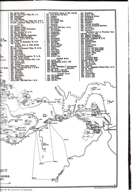
Towards the bottom of the top map there's a large rectangle pointing downwards - the War Department lot for the Military Sanatorium.
But outside that is a larger outline, with the boundary stones marked as M.R. 1, M.R.2, etc. Any idea what that stood for? (And whether any of the stones are still standing?)
Thanks Moddsey. The name sounds right, though it's a new one to me. Any idea what was different about it? Seems it would have been easier to just make the WDL bigger.
As I undestand after a land survey had been conducted, the Military Authorities could in essence after deliberation with the Government 'request' certain land or land adjoining military land to be reserved for future military use. However, the land use of the reserved area at the time had yet to be determined.
With War Department Lots, these areas of land had been designated for specific military purposes e.g. Victoria Barracks, BMH etc
")
Comments
What's an "M.R." ?
Towards the bottom of the top map there's a large rectangle pointing downwards - the War Department lot for the Military Sanatorium.
But outside that is a larger outline, with the boundary stones marked as M.R. 1, M.R.2, etc. Any idea what that stood for? (And whether any of the stones are still standing?)
Re: M.R.
I think M. R. stands for Military Reservation Area. I have not seen any boundary stones delineating the outline of the area.
Re: M.R.
Thanks Moddsey. The name sounds right, though it's a new one to me. Any idea what was different about it? Seems it would have been easier to just make the WDL bigger.
Re: M. R. vs W. D. L.
As I undestand after a land survey had been conducted, the Military Authorities could in essence after deliberation with the Government 'request' certain land or land adjoining military land to be reserved for future military use. However, the land use of the reserved area at the time had yet to be determined.
With War Department Lots, these areas of land had been designated for specific military purposes e.g. Victoria Barracks, BMH etc
Thanks Moddsey, I'll keep an
Thanks Moddsey, I'll keep an eye out for any other references to 'military reservation'.
land leases
incidentally David Webb has an excellent article detailing the history of land leases. Not sure best place to put it:
http://www.webb-site.com/articles/leases1.asp
1899 Map of the Peak
A comparison map from 1899.