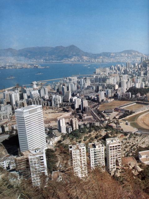
The Diamaru sign is just about visible by zooming right in directly above the Craigengower Cricket Club's buildings and in line with the upper seawall arm of the typhoon shelter. Presumably the buildings in the bottom of the picture are part of Shiu Fai Terrace. IDJ
Date picture taken
1 Nov 1969
Gallery
Shows place(s)

Comments
Interesting photo. The big
Interesting photo. The big building in the lft foreground is the AIA building at the corner of Stubbs Rd and Queens Rd East
Morsre interestingly is the fact that one can see the chimneys of the old North Point power station which was later dismanelted and reassembled in China on the other side of Deep Bay
Yes, the buildings in the
Yes, the buildings in the foreground are Shiu Fai Terrace, so this was either taken from Bowen Path, or from Stubbs Road.
1969 Happy Valley photo
I recognize the old HKFC stadium of course, and the Military (Defence Force?) ground, at the western end of Sports Rd. But what I would ilke to know is - what is the large clearing behind the AIA Building being prepared for? Is that Morrison Hill?
Re: 1969 Happy Valley Photo
Hi there,
Yes, the clearing behind AIA was what's left of the Morrison Hill. Some construction is going on there but cannot pin point what. By the left hand side of the AIA Building, you should be able to see part of Mount Paris, the lower car park of Wah Yan College Hong Kong.
Two school buildings could be seen just left of the AIA Building. If I'm not mistaken they were from right to left, Tung Wah Group of Hospital Li Chi Ho Primary School (old building) and St. Joseph's Primary School. The two schools had been seperated by a Wood Road. I think the building seen right next to AIA Building was the west wing of the old Tang Shiu Kin Hospital.
Best Regards,
T
morrison hill
That's right. The clearing north of the Stubbs rd-Queen's Rd East junction is the Morrison hill. In the early days, it was a hill but rocks were removed from there for the Wanchai coastline reclamation. Its official name is "Morrison hill quarry" or " 摩利臣山石礦場". Already before the war, it was filled with squatter huts. In 1965, the government even resettled here residents living in some "dangerous" structurally defective flats of Queen's Rd west and Hollywood Rd. Around 1967, the government again resettled those squatters and cleared out all the huts. Tang Shiu Kin Hospital 鄧肇堅醫院 was built there and opened in 1969.
Comparing photos of Morrison hill in 1965 and 1967, one can see in 1967 most of huts were demolished and tall fences were set up around certain area.
=======================================
1965
=========================================
1967
Muslim cemetery in centre,…
Muslim cemetery in centre, St Michael's Catholic cemetery to the right of the photo and the 3rd generation Khalsa Diwan Sikh Temple to the left of the Muslim cemetery.