I don't think that this is of Yuen Long. The countryside immediately around Yuen Long was very flat.
N.B. After so much debate, Phil has found the exact location. His perseverance and skill identified the slide photograph as having been taken at Sai Kung Fui Yiu Ha, right next to the road running up the Eastern side of the New Territories. As he points out in the 1950s the road might have been called either Po Tung Road or possibly Hiram's Highway - which I suggest might be the original name, and it would have been just to the left of the photograph. Hopefully, I can now rename the pin and move it to the correct spot on the Gwulo map. Please let me know if any more changes are necessary. I have edited the next paragraph in an attempt to remind readers of how long and difficult a journey we have all been on. Andrew
The following fascinating and rather tortuous debate finally reveals that the village in question is actually the coastal one of Fui Yiu Ha in Sai Kung. Aerial photographs can sometimes shed a light, even though they might be blurry, on how things were in the past. Thank you to everyone who has entered into the Gwulo spirit of detective work that the site is so good at providing. As my final comment at the end of the thread suggests, perhaps somebody might be able to visit the correct site and take a photograph for then and now comparison. One might even be available on Google Street view. I have now added a pin on the Gwulo map in what I hope is the correct place - but it might need adjusting.
Comments
alternative site
I'd like to offer an alternative site rather than tear everyone else's down all the time, it's only fair that I should make a suggestion rather than just find fault with everyone else's. Apologies if my posts have upset anyone.
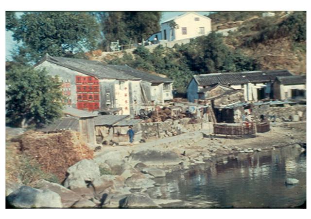
I *think* that when Moddsey's ebay image says "Sai Kung Village", it is meant - specifically - the old village rather than some village within Sai Kung District. Please look at this image taken from Tymon's excellent HK Map Viewer for 1963. It shows the whole of what was once Sai Kung village peninsula. The original photo has offered some clues - close to water (but not exposed to waves), a sloped background with a more modern type of building (as opposed to the shoreline traditional style houses) with a small parcel of land (demarcated by what looks to be a green metal gate), a small track around the water's edge, a clump of something at the far left of the screen, an advert on the side of a house (so it must be for the benefit of someone nearby or passing through?).
I've squared a section below that includes several of these features with some additional ones.
1. It is in fact part of Sai Kung Village
2. Hut on a hillside behind (with the roof ridge running the correct direction, as well as a small area with parked cars which indicates some open land next door. This hut actually lines up with house number 181, although the current building is a modern 3 floor village house.
3. The small track by the water
4. Two sets of waterfront buildings. Look closely and you can see the one on the *right* has two small huts in front of it similar to Paddy's image - the roof lines of these small huts also seem to match. The row of buildings on the left have some front plots which can just be discerned on the aerial image. Also, the front of the building allows a line of sight to the wall on the other one, which was my main problem with Tui Min Hoi.
5. The clump on the left could be the small bit of land that is intersected by the left hand of my rectangle.
6. Note the protected area of water and the fact that the advert wall of the building would be the one facing the main road (Po Tung Road) which would explain why the advert was placed there.
Anyway, please ponder and let me know what you think.
If you need to see the original resolution, it can be viewed on HK Map viewer.with the 1963.2 reference layer.
Sai Kung Village
Hi philk, This is it! Wonderful, Amazing, Impressive! Everything fits. A big thank you and others who have also contributed towards this search. Regards, Peter
Re: Alternative View
I must say the aerial maps have been put to good use in trying to identify the location of the scene.
A long way from Yuen Long but I think Phil has got it right with his analysis and the location. Well done and good collaboration by all.
Phil - you are a star! I
Phil - you are a star! I kept looking at the Sai Kung peninsula in the aerial photograph book, wondering whether there was another similar small bay to the one at Tui Min Hoi, and there it was staring me in the face. Being so close to the important road it would have immediately attracted the photographer's attention. In those days most photographs, including my own were taken close to roads. Now, I think that I will have to edit the first page in this roller coaster of an investigation. Any suggestions? Regards, Andrew
Sai Kung
nice to know that staying up half the night with my eyes glued to my computer screen has paid off. In terms of edit I don't know if that stretch of road has always been called Po Tung Road or whether it was originally part of Hiram's Highway. Also, maps appear to mark this area as "Fui Yiu Ha" (灰窰下) rather than as Sai Kung Village, so I'm not sure which is better. Perhaps just mark the image as "Sai Kung Fui Yiu Ha" until someone can better advise.
Thanks Phil. I'll edit the
Thanks Phil. I'll edit the first page and the title as you suggest and also move the pin to a more accurate place - again hopefully. Let me know if amendments are needed. Andrew
Aerial Views of Sai Kung
For those interested in views of Sai Kung, there is a quite a number of low level aerial photos here from the 1960/70s.
Sai Kung, Fu Yiu Ha
Admirable detective work on this fascinating photograph.
Fu Yiu Ha is absolutely correct with the photo being taken from Hiram's Highway (at that time probably ending in Sai Kung Market further down the road.)
The building on the hill behing is most probably the original Rural Committee building, still in the same location.
Fu Yiu Ha and the nearby Tin Hau Temple on the other side of the hill is the Sai Kung end of the ancient road from Tai Wai via Siu Lek Yue, Mui Chi Lam, Mau Ping and the (originally named) Delta Pass on the Maclehose Trail: https://tinyurl.com/29pzvpb9 (Walk No 1 on HK's Boulder Trackways)
The houses, originally on the sea front, have been rebuilt but this area of Old Town is still very pleasant.. The bay was reclaimed to built Star Plaza, some industrial buildings (to become housing) and the Lakeside Garden estate. (There is no "lake"!)
There are still some very pleasant Tui Min Hui (Across the Sea) originally sea front village houses on the other side of Lakeside Gardens.
I will submit some modern photos shortly.
Yes, thank you to everyone
Yes, thank you to everyone who has contributed to the investigation of the old slide and helped to proved a successful answer to where the photograph was taken. Looking at Google Earth and Street view it is just possible to make out where the photographer stood beside Hiram's Highway - most probably on the low, rocky knoll that is visible next to the shoreline on the aerial photograph. Rather a restricted view on Street View tends to confirm that the old buildings have been replaced by modern ones as pointed out by Guy, but they look to be on the same footings.
Now, as suggested by terewong, perhaps we can turn our eagle eyes to sorting out where the other colour slide named 'Yuen Long village1' in Paddy's gallery was taken. To me it certainly looks like the scenery that I remember from that area in the late 1950s and, although I have trawled through all my own photographs and others in the 367 Association gallery, I have not been able to match that skyline with that on any other identified images. Judging by the shadows, the camera was most probably pointed to the North, and the slide has not been flipped. Unfortunately, tree planting and buildings constructed in the years since 1950's have severely restricted Google's Street View along the old main road across the New Territories from the West through Yuen Long, Kam Tin and on to beyond Sek Kong - that road is my favourite for a tentative location. Perhaps there are other images on Gwulo that might show that skyline. Regards, Andrew
Yeah. The pic Sai Kung Aerial
Yeah. The pic Sai Kung Aerial Image 1963 Edited , by Philk looks more reasonable in the angle of view. The commerical sign at the side of the house, attractive to the people from the road.
Thanks Philk
Thank you Guy for uploading
Thank you Guy for uploading the photographs against the pin on the map. I think that they show how the 'new' buildings still fit neatly into the general layout of the row of houses in the late 1950s. Well done.
Back to the discussion about
Back to the discussion about Sai Kung Tui Min Hoi, I remember this photo, the topic of Jockey club's floating clinic. Do you think the place in this photo is Sai Kung Tui Min Hoi ?
source: https://www.flickr.com/photos/eat_see/2384204239/
Thanks terewong. I don't
Thanks terewong. I don't think that it is Tui Min Hoi. If you zoom in on this image you will see that, while the foreground looks promising, there are severl discrepancies with the aerial photograph. The shape of the hillside across the inlet on the right does not match the one on the aerial photograph (where I understand the original Sai Kung village stood. Also, the row of objects in the far bay is more like a row of sampans or junks than buildings and beyond them is another inlet, or perhaps a reservoir, that does not fit in with the aerial photograph. Perhaps the promnent high conical hill might provide us with a good lead.
Kat O
terewong - that image is of Kat O looking south.
Thanks Andrew Suddaby, I
Thanks Andrew Suddaby, I agree. I better put more focus on Yuen Long photos which I know more on this district, thanks a lot Andrew your site :-)
Royal Hong Kong Jockey Club Floating Clinics
Kat O is surely correct. Here is some history on the RHKJC floating clinics:
Floating clinics, Chee Hong and Chee Wan, 1973
Chee Hong and Chee Wan, with their names chosen by then Club Steward Dr. Chau Sik Nin, were the two floating clinics donated by the Club in 1958 and 1959, respectively, to the government for the provision of out-patient clinical services to residents of outlying islands and remote villages. Chee Hong, built at a cost of about HK$370,000, served the area of the northern part of Lantau, southern and western seaboards of Po Tai and Sai Kung Peninsula. Both ships were constructed by the Taikoo Dockyard & Engineering Company of Hong Kong Limited.
https://www.hkmemory.hk/MHK/collections/hkjc/All_Items/Images/201201/t2…
Hi terewong. Perhaps you
Hi terewong. Perhaps you could locate 'Yuen Long village 1' I suspect that this photograph was taken somewhere broadly in the Yuen Long, Kamtin area - but probably quite close to the main West / East road. It reminds me so much of some of my own photographs taken in that area, but doesn't match any of them. The hill profile might be a good starting point. I have just realised that there is a danger of starting up a new thread on this topic! Please ignore this one and go to the thread already started, which already has one or two contributions. Andrew
Pak Wai Tree House, Kam Tin?
This could be the famous Pak Wai Tree House in the heritage villages north of the Kam Tin By-pass. https://ilovehongkong.org/kam-tin-tree-house-new-territories-hong-kong/
An interesting suggestion Guy
An interesting suggestion Guy, but there does not appear to be any building or ruin immediately under the tree on the slide photograph. Street view from a large pond (the only clear view possible from anywhere near the tree) does not show a skyline that looks like that on the old slide.
Hi Guy. In order to avoid
Hi Guy. In order to avoid duplication of threads, I am switching my replies and comments to the other thread. You will see that following a suggestion I have also flipped 'Paddy's' image. There is also a suggestion that the photograph was taken much further to the West on the Castle Peak Road but looking towards the SW rather than the North. Regards, Andrew
1959 View
Would the photo below be the full view of the original photo? The village houses and the building on the hill seem to match.
1959 view
yes, good find. Definitely a match. The 2-story old building centre right with the decorative roof centrepiece is still around (it's listed as #43 on Open Street Map).
Re: 1959 View
Thanks Phil. Will amend the photo title.
Thanks Phil and Moddsey. …
Thanks Phil and Moddsey. Yes a great match. Paddy must have taken his photograph from the foreshore just down from the road and quite close to the buildings on the left of Moddsey's contribution.