Again, I don't think that this is of Yuen Long. There appear to be hills in the background and the water looks tidal. Thanks T, I hope that I've now got it right way round.
The concentration of the Stilt Houses made it a major location. I could think of either Tai O or Tai Po, near the Yuen Chan Chau area. You long around the Nam Sang Wai area still have a small number of these along San Pui River, but uncertain about it.
The more times that I look at this photograph the more I think that it is of the ferry at Tai O on Lantau. Being low tide the ferry has to stay in mid channel and the people must cross onto it at either end by plank. I wonder whether the ferry lady still charged them! One of my photographs taken in 1981 shows the ferry in use and the stilts on the left of the far bank even look to be the same ones, but I have forgotten how to add that image here.
Something still does not add up. I am still in doubt with the location of the photo. That does not look like the ferry crossing that I experienced in the 1970s\1980s. That crossing would likely be a bit wider.
I tend to believe that is near the Sun Kei Bridge, which was built by the villagers in the 1970s. All the buildings around the Sun Kei Bridge area are mostly Stilts. Where the ferry crossing was located, there are concrete\stone buildings.
This aerial photo of 1956 showed the approximate location of the ferry crossing:
San Kei Bridge does not exist until June 1979. It should be around the edge of the magnifying glass of the photo above at about eight o'clock. In present day Google Maps, it is in the middle of this.
The Sun Kei Bridged was funded and built by the villagers. It is a wooden draw bridge (made of Borneo Ironwood, I think, especially for the foundation that sit under water), which opens when taller boats are going through, like the present day concrete\metal foot bridge at the former ferry crossing.
Still uncertain if that is the location of your photo though, except over there, the houses on both sides are mostly stilts. If compared with today, there were slightly less stilts houses in the 1950s though. In your photo there were a few houses with tiled roof at the back.
If you scroll through the Lantau section in my 1981 gallery you will find several photographs of the Tai O creek, including two or three that have a ferry on them. My visit was a long time ago, but it does look as though I might have taken photographs of more than one ferry. Sorry, but I don't seem to be able to add those images to this conversation. Are they of any help in resolving this problem? Incidentally, is Paddy's image still the wrong way round?
The issue for me is that I wasn't even born yet in 1950s. What I can do is to try digging somewhere. I may go to Tai O to walk around (an excuse for birding) when the weather is better and see if some of the white concrete\stones shown in the photo are still there in low tide..
BTW, the flipped photo showed the signs of the Watson's soft drinks on the righthand side.
Hi Andrew. Looking at Paddy's other photos of the NT which I discovered to be images of commercial slides, I think the main photo may also fall into the same category.
Similar to the Sai Kung photo which was mis-labelled as "Yuen Long", this image may have been annotated as being from Yuen Long on the slide as well.
Time permitting, will look into the anomaly and see if auction sites hold the same photo/slide.
I should have realised years ago that Paddy probably didn't take the colour transparency photos. I was very unusual amongst my Service contemporaries in using Kodachrome film - it being very expensive and required the exposed film to be sent either to the USA or, as in my case, to Britain for processing.
Perhaps it isn't worth your time in following things up at Tai - but a spot of bird watching could make it worthwhile.
During my visit to Tai O in November 2025, took photos of the San Ki bridge. I've created a place for it (Sun Ki Bridge (Tai O) [1979- ]). I found a 2005 photo which might help to find the location of the original photo. The Chinese Wikipedia reports June 1979 as the opening date of the bridge. The original photo is from 1958 - the bridge hadn't been built yet.
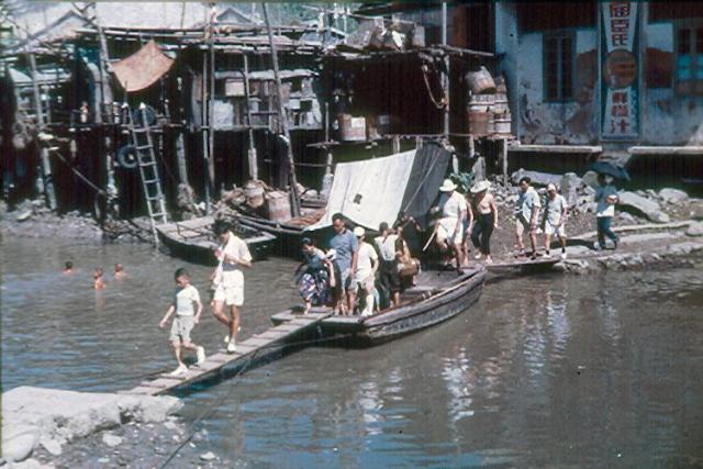
This photo appears to show a boat being used to support two planks that span a bit of water to form an improvised bridge.
A rope can be seen going from the end of the boat in the foreground - on the right hand side - to roughly the centre of the plank in the foreground, and then back to shore in the foreground. A rope is also visible from roughly the centre of the left hand side of the plank in the foreground also going toward the shore in the foreground.
No ropes are visible from the end of the boat in the background, but there would have to be something to keep the boat in position against the pull of the ropes securing the opposite end of the boat to the shore & things moving around as a result of people walking across the "bridge".
If this were a ferry (ignoring how it is secured in the foreground suggests there would be a bit of effort to tie up/cast off after/before such a short run), I'd imagine it would be pulled by hand by someone. But there is nothing visible that this could be done with. There also doesn't seem to be anyone on board the boat who isn't seemingly walking from the shoreline in the background to the shoreline in the foreground.
So where might such an improvised bridge have been?
Note the difference in angle in the approaches from the shoreline to the boat from either side of the water.
The relatively short distance spanned by this bridge & the angle between the bits of land on either side that I'd imagine that perhaps might be visible in an aerial photo might help identify the location.
Unless the water has widened & a number of the stilt houses have ceased to exist over time, I'd be tempted to suggest this photo was taken somewhere along the channel north of the Sun Ki bridge & it's rather unlikely that it was anywhere along the creek as where the creek is this narrow, it seems there were/are not so many stilt houses.
There is a very clear photograph on hkmaps.hk (1962.2 aerial survey). In the photo, many narrow waterways can be seen. Judged from the photo, obviously a couple of people are crossing the creek; this should not be in a remote area. As suggested before, this could be near todays Sun Ki Bridge. The bridge spans the creek passing stilt houses (possibly built on a peninsula). This "peninsula" can be seen in the 1962 aerial photograph. The "bridge" could have been between this "peninsula" and the shore.
This is just a speculation and could be wrong, especially because of the boat traffic there (see boats in the 1962 aerial photograph).
The straight line distance in the 1963.2 aerial photo from the bit of what looks to be a bit of land of some sort sticking out from where the east end of the Sun Ki Bridge is now - across to the other side - appears to be a tad shy of 50 metres.
The plank in the foreground of the picture here is roughly the same length as the boat. The plank in the background of the picture here might be a little less than the length of the boat.
Let's say all three are of equal length. In order to span the distance where the Sun Ki Bridge is - if this picture was taken there - then the boat is somewhere around 15 metres in length.
And in the intervening ~5 years the number & location of stilt houses changed, regardless of which end of the location of the present-day Sun Ki Bridge this photo might show.
Earlier I misled you by referencing my 1981 photographs of Tai O as being in the New Territories group. I now realise that in my 1981 gallery, I did not group the images in sperate folders, so I'm afraid finding the half dozen or so Tai O images will require a search. APOLOGIES . In answer to several questions that have been raised, the photographs show the tidal creek to be very low in water and also having quite large junks moored in them either in the water or on the mud.
I don't know whether this helps but, looking at Google Earth I am pretty certain that the ferry that I used to cross the creek on my way to taking the Hong Kong ferry at what is now named as the 'Old Tai O Public Pier' was replaced by the Tai O Market Street Drawbridge. We had had a long day on Lantau and having enjoyed a cold drink (another photograph) on Market Street and close to the ferry. we did not explore the town but headed straight for the Hong Kong Ferry. So, I suspect that all my creek photographs were taken in that one place but from different sides of the creek.
Went to Tai O earlier today but I was unable to find anything that may have matched anything in the photo. When I arrived it past high tide but was not the lowest level yet. That would be a bit after dark.
The location around present day Sun Ki Bridge is inconclusive. There is also the issue or privacy as most of the stilt houses are not opened to the public and we really need to be somewhere along the waterway in order to observe.
I have been looking at the excellent book, 'Hong Kong in Old Times, aerial photographs taken in 1964', and also the very detailed holiday diary that my wife and I wrote while on holiday in 1981. All the photographs taken then, and now on Gwulo, are in that diary. From these, I am pretty certain that we must have crossed the creek by the rope ferry that was later replaced by the Tai Chung bridge, also known as the Market Street draw bridge. My various photographs showing the creek, junks, etc., were definitely taken from one or probably both sides of the creek banks there.
Viewing Google Earth street view of that location I am amazed by how much everything has changed since 1981. Then it was an unspoiled scene of the village and its people going about their business, with my wife and I just observers. Now, it is just another major a tourist attraction, and no wonder you found it virtually impossible to identify anything.
The photograph that Moddsey added earlier in this conversation shows a very large and important looking building at upper centre ( what was that building?) and I suspect that that commercial slide is of where the Sun Ki bridge was eventually built.
Comments
Re: Yeun Long?
Hi Andrew,
An advertisement at the back showed the photo was flipped horizontally.
Thanks & Best Regards,
T
Tidal river
Yuen long creek is tidal. But not sure where this photo was along any of the rivers.....
Could be Tai O
Could be Tai O
Re: Location of the photo
Hi There,
The concentration of the Stilt Houses made it a major location. I could think of either Tai O or Tai Po, near the Yuen Chan Chau area. You long around the Nam Sang Wai area still have a small number of these along San Pui River, but uncertain about it.
T
Hi Thomas, The more times…
Hi Thomas,
The more times that I look at this photograph the more I think that it is of the ferry at Tai O on Lantau. Being low tide the ferry has to stay in mid channel and the people must cross onto it at either end by plank. I wonder whether the ferry lady still charged them! One of my photographs taken in 1981 shows the ferry in use and the stilts on the left of the far bank even look to be the same ones, but I have forgotten how to add that image here.
Regards Andrew
1959 Tai O Creek
The long ladders beside the stilted houses appear to suggest that it is Tai O. A commercial slide of Tai O from the late 1950s below.
Thanks Moddsey. I'd…
Thanks Moddsey. I'd definitely settle for Tai O. Andrew
Re: Tai O
Hi There,
Something still does not add up. I am still in doubt with the location of the photo. That does not look like the ferry crossing that I experienced in the 1970s\1980s. That crossing would likely be a bit wider.
I tend to believe that is near the Sun Kei Bridge, which was built by the villagers in the 1970s. All the buildings around the Sun Kei Bridge area are mostly Stilts. Where the ferry crossing was located, there are concrete\stone buildings.
This aerial photo of 1956 showed the approximate location of the ferry crossing:
T.
Hi T. Where is Sun Kei and…
Hi T.
Where is Sun Kei and its bridge?
Andrew
Re: San Kei Bridge
Hi Andrew,
San Kei Bridge does not exist until June 1979. It should be around the edge of the magnifying glass of the photo above at about eight o'clock. In present day Google Maps, it is in the middle of this.
The Sun Kei Bridged was funded and built by the villagers. It is a wooden draw bridge (made of Borneo Ironwood, I think, especially for the foundation that sit under water), which opens when taller boats are going through, like the present day concrete\metal foot bridge at the former ferry crossing.
Still uncertain if that is the location of your photo though, except over there, the houses on both sides are mostly stilts. If compared with today, there were slightly less stilts houses in the 1950s though. In your photo there were a few houses with tiled roof at the back.
T
Hi T,If you scroll through…
Hi T,
If you scroll through the Lantau section in my 1981 gallery you will find several photographs of the Tai O creek, including two or three that have a ferry on them. My visit was a long time ago, but it does look as though I might have taken photographs of more than one ferry. Sorry, but I don't seem to be able to add those images to this conversation. Are they of any help in resolving this problem? Incidentally, is Paddy's image still the wrong way round?
Andrew
Re: Sun Kei Bridge
Hi Andrew,
The issue for me is that I wasn't even born yet in 1950s. What I can do is to try digging somewhere. I may go to Tai O to walk around (an excuse for birding) when the weather is better and see if some of the white concrete\stones shown in the photo are still there in low tide..
BTW, the flipped photo showed the signs of the Watson's soft drinks on the righthand side.
T
Hi T, It's a tricky one for…
Hi T,
It's a tricky one for both of us! Is Paddy's photograph now the right way round?
Andrew
Commercial Slide
Hi Andrew. Looking at Paddy's other photos of the NT which I discovered to be images of commercial slides, I think the main photo may also fall into the same category.
Similar to the Sai Kung photo which was mis-labelled as "Yuen Long", this image may have been annotated as being from Yuen Long on the slide as well.
Time permitting, will look into the anomaly and see if auction sites hold the same photo/slide.
Hi T, I should have realised…
Hi T,
I should have realised years ago that Paddy probably didn't take the colour transparency photos. I was very unusual amongst my Service contemporaries in using Kodachrome film - it being very expensive and required the exposed film to be sent either to the USA or, as in my case, to Britain for processing.
Perhaps it isn't worth your time in following things up at Tai - but a spot of bird watching could make it worthwhile.
Regards, Andrew
Re: Paddy's photo
Hi Andrew,
The orientation of the photo is now correct.
T
San Ki bridge
Hi Andrew and T.
During my visit to Tai O in November 2025, took photos of the San Ki bridge. I've created a place for it (Sun Ki Bridge (Tai O) [1979- ]). I found a 2005 photo which might help to find the location of the original photo. The Chinese Wikipedia reports June 1979 as the opening date of the bridge. The original photo is from 1958 - the bridge hadn't been built yet.
Improvised bridge
This photo appears to show a boat being used to support two planks that span a bit of water to form an improvised bridge.
A rope can be seen going from the end of the boat in the foreground - on the right hand side - to roughly the centre of the plank in the foreground, and then back to shore in the foreground. A rope is also visible from roughly the centre of the left hand side of the plank in the foreground also going toward the shore in the foreground.
No ropes are visible from the end of the boat in the background, but there would have to be something to keep the boat in position against the pull of the ropes securing the opposite end of the boat to the shore & things moving around as a result of people walking across the "bridge".
If this were a ferry (ignoring how it is secured in the foreground suggests there would be a bit of effort to tie up/cast off after/before such a short run), I'd imagine it would be pulled by hand by someone. But there is nothing visible that this could be done with. There also doesn't seem to be anyone on board the boat who isn't seemingly walking from the shoreline in the background to the shoreline in the foreground.
So where might such an improvised bridge have been?
Note the difference in angle in the approaches from the shoreline to the boat from either side of the water.
The relatively short distance spanned by this bridge & the angle between the bits of land on either side that I'd imagine that perhaps might be visible in an aerial photo might help identify the location.
Unless the water has widened & a number of the stilt houses have ceased to exist over time, I'd be tempted to suggest this photo was taken somewhere along the channel north of the Sun Ki bridge & it's rather unlikely that it was anywhere along the creek as where the creek is this narrow, it seems there were/are not so many stilt houses.
-kpl.
Aerial photograph 1962
There is a very clear photograph on hkmaps.hk (1962.2 aerial survey). In the photo, many narrow waterways can be seen. Judged from the photo, obviously a couple of people are crossing the creek; this should not be in a remote area. As suggested before, this could be near todays Sun Ki Bridge. The bridge spans the creek passing stilt houses (possibly built on a peninsula). This "peninsula" can be seen in the 1962 aerial photograph. The "bridge" could have been between this "peninsula" and the shore.
This is just a speculation and could be wrong, especially because of the boat traffic there (see boats in the 1962 aerial photograph).
?
The straight line distance in the 1963.2 aerial photo from the bit of what looks to be a bit of land of some sort sticking out from where the east end of the Sun Ki Bridge is now - across to the other side - appears to be a tad shy of 50 metres.
The plank in the foreground of the picture here is roughly the same length as the boat. The plank in the background of the picture here might be a little less than the length of the boat.
Let's say all three are of equal length. In order to span the distance where the Sun Ki Bridge is - if this picture was taken there - then the boat is somewhere around 15 metres in length.
And in the intervening ~5 years the number & location of stilt houses changed, regardless of which end of the location of the present-day Sun Ki Bridge this photo might show.
-kpl.
Hi everyone.Earlier I…
Hi everyone.
Earlier I misled you by referencing my 1981 photographs of Tai O as being in the New Territories group. I now realise that in my 1981 gallery, I did not group the images in sperate folders, so I'm afraid finding the half dozen or so Tai O images will require a search. APOLOGIES . In answer to several questions that have been raised, the photographs show the tidal creek to be very low in water and also having quite large junks moored in them either in the water or on the mud.
I don't know whether this helps but, looking at Google Earth I am pretty certain that the ferry that I used to cross the creek on my way to taking the Hong Kong ferry at what is now named as the 'Old Tai O Public Pier' was replaced by the Tai O Market Street Drawbridge. We had had a long day on Lantau and having enjoyed a cold drink (another photograph) on Market Street and close to the ferry. we did not explore the town but headed straight for the Hong Kong Ferry. So, I suspect that all my creek photographs were taken in that one place but from different sides of the creek.
Andrew
Re: Tai O
Hi There,
Went to Tai O earlier today but I was unable to find anything that may have matched anything in the photo. When I arrived it past high tide but was not the lowest level yet. That would be a bit after dark.
The location around present day Sun Ki Bridge is inconclusive. There is also the issue or privacy as most of the stilt houses are not opened to the public and we really need to be somewhere along the waterway in order to observe.
T
Hi T, I have been looking at…
Hi T,
I have been looking at the excellent book, 'Hong Kong in Old Times, aerial photographs taken in 1964', and also the very detailed holiday diary that my wife and I wrote while on holiday in 1981. All the photographs taken then, and now on Gwulo, are in that diary. From these, I am pretty certain that we must have crossed the creek by the rope ferry that was later replaced by the Tai Chung bridge, also known as the Market Street draw bridge. My various photographs showing the creek, junks, etc., were definitely taken from one or probably both sides of the creek banks there.
Viewing Google Earth street view of that location I am amazed by how much everything has changed since 1981. Then it was an unspoiled scene of the village and its people going about their business, with my wife and I just observers. Now, it is just another major a tourist attraction, and no wonder you found it virtually impossible to identify anything.
The photograph that Moddsey added earlier in this conversation shows a very large and important looking building at upper centre ( what was that building?) and I suspect that that commercial slide is of where the Sun Ki bridge was eventually built.
Regards to everyone, Andrew