I don't think that this is of Yuen Long. The countryside immediately around Yuen Long was very flat.
N.B. After so much debate, Phil has found the exact location. His perseverance and skill identified the slide photograph as having been taken at Sai Kung Fui Yiu Ha, right next to the road running up the Eastern side of the New Territories. As he points out in the 1950s the road might have been called either Po Tung Road or possibly Hiram's Highway - which I suggest might be the original name, and it would have been just to the left of the photograph. Hopefully, I can now rename the pin and move it to the correct spot on the Gwulo map. Please let me know if any more changes are necessary. I have edited the next paragraph in an attempt to remind readers of how long and difficult a journey we have all been on. Andrew
The following fascinating and rather tortuous debate finally reveals that the village in question is actually the coastal one of Fui Yiu Ha in Sai Kung. Aerial photographs can sometimes shed a light, even though they might be blurry, on how things were in the past. Thank you to everyone who has entered into the Gwulo spirit of detective work that the site is so good at providing. As my final comment at the end of the thread suggests, perhaps somebody might be able to visit the correct site and take a photograph for then and now comparison. One might even be available on Google Street view. I have now added a pin on the Gwulo map in what I hope is the correct place - but it might need adjusting.
Comments
Some one said this pic is Tai
Some one said this pic is Tai Po Sam Mun Chai
She Shan area west of Tai Po
Thank you terewong for leading me to this likely the right place. Regards, Peter
Addendum: 1963.2 air photo - https://www.hkmaps.hk/mapviewer.html
From looking at map overlays, I estimated that the location of the house beyond the steep path corresponds to the current building (much larger in size) on the north side of Shek Lin Road and about 240 metres north-northwest of the present Lin Au Public Toilet. This is visible in current Google aerial photo; notice the near-round paddy and the two three rows of houses to the southwest - they seem to match the current view.
Thank you for the suggestion.
Thank you and Peter for the suggestion. I am fairly certain that the colour photographs in Paddy's gallery are taken off commercial slides (poor defintion suggesting that they had been copied) and that he didn't have a clear idea where some of them were taken. The descriptions that he gave me are basically his guesses and it is very unlikely that he went anywhere near Tai Po Sam Mun Chai. I have checked this out on Google Earth and street view but it is difficuolt to see for sure - but places have changed so much over the years! Perhaps Peter's contribution solves the mystery.
She Shan area west of Tai Po
Thank you Andrew for the feedback. I have been wrong before. This time, I think there are enough hints. Regards, Peter
Re: Photo
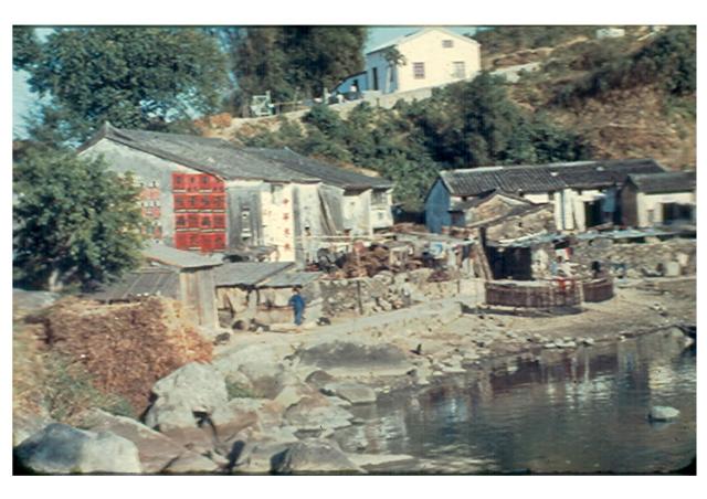
It is a commercial slide and titled "Yuen Long". The slide was part of a collection of slides of the New Territories. Difficult to pinpoint the actual location.
Site of 1958 Ground/Water Photo
Thank you moddsey for the feedback. I have moved the camera pin a bit to the east. See if this makes sense, assuming no significant physical changes took place between 1958 and 1963.
A. The spot where the camera holder was standing. This brings the vantage point closer to the east shore where the big boulders are though not visible in the 1963 air photo - exposed during a dry spell perhaps. The photo centre runs a bit to the right (east) of the house on the hill.
B. Shrub (dark spot) on the right edge, possibly the same one in the 1958 photo.
B-C The line between B and C are farm equipments or crops left to dry in the sun.
C. Steep path.
D The 1963 air photo was taken in late afternoon, as the shadow(s) are to the northeast. Below "D", if my assumption is correct, are the row of houses that cast big shadow on the ground. The shadow's straight line-edge (just below the letter D) seems to agree with the one that would have been cast by the two houses on the left. However, what puzzles me is why their roofs are not visible in the air photo, is it because they are black in colour? The edge of shadow between B and D is also fairly straight.
E. Shadow cast by a big tree southeast of the house.
I will continue to look for other possible sites. Regards, Peter
I hestitate to add my own
I hestitate to add my own thoughts to this interesting debate as my knowledge of the New Territories in the 1950s is strictly limited to the few trips that I made there and on those occasions I tended to stick to the relatively well known places that were easily accessible by public transport. With my own photographs I am usually fairly accurate about locations but with images supplied to me by members of the 367 Association, I often had no idea where they were taken. Peter's interesting analysis of the photograph using the map and aerial photograph does look good for Lin Au being the location, but two things worry me. Firstly, according to Google, it is still rather a remote place and in the late 1950s even a commercial photographer, whom we can be pretty sure took the photograph, would have been unlikely to go so far off the beaten track, when there were so many similar iconic scenes that he would have found much more easily - even around Yuen Long. Secondly, although the paddy fields do not go right up to where the village is shown on the the aerial photograph it looks much more like a river bed or even a coastal scene, although the latter is less likely as Moddsey's comment that the slide had 'Yuen Long' printed on it tends to rule that out. On the other hand the photographer could very well have been standing on the path that is shown on the aerial photograph, with the paddy fields behind him and the rocks simply evidence of the fields having been cleared of rocks and stones. Peter's use of the map and aerial photograph certainly do look pretty good for Lin Au and I hope that my concerns are unjustified. Andrew
She Shan area west of Tai Po
Thank you Andrew for your comments. Possibility about those rocks ...
The 1963 air photo shows there was a road extending from Tai Po to this place. I think it was good enough to transport machinery to the site, and that this road already existed in 1958. On the south side of the estate near the paddy, there is a structure that looks like a barn - where they stored the machine. The placement of the barn necessitated land clearing and they moved the rocks to the shore up the creek's bank. Regards, Peter
At least I never seen such
At least I never seen such place in Yuen Long or even in the old pics of Yuen Long. The building at the top is a church, seems still exists.
Hi. Thanks for the
Hi. Thanks for the interesting comment. Are you sure that the building is a church? We had thought that it was a large house. If it is a church, can you confirm that the photograph was actually taken in Lin Au? Regards, Andrew
Re: Photo
There are 4 vertical red Chinese characters on a light coloured wall in the centre of the photo. Any comments that the photo needs to be horizontally flipped for correctly viewing the characters?
She Shan area west of Tai Po (?)
Thank you moddsey for the flipping idea; I didn't think of that. One character appears to work either way, same for a few of the 16 black characters on red background. The rest are too fuzzy on my screen to decide. Other readers may have better results. Regards, Peter
Re: Photo
A slightly clearer photo appears here for sale.
Chinese characters - flipped or not
Thank you moddsey.
On the vertical sign, it says, by sound - Zhong Wa Mite Po; by translation (= China rice shop). The first two characters are symetrical down the middle and they look ok either way. The third character (rice) looks flipped by its horizontal stroke, and the bottom character is too fuzzy to be recognized so it could be a flipped "shop".
On those 16 words, it is interesting to note some are symetrical down the middle. From left (house corner) to right, the bottom word in the first column is a flipped nine in Chinese, so is the bottom word in the third column. Last column's second word looks flipped, sorry my computer does not have screen-grab capabilty to fiip it.
Considering the hints I have put forward, I am now struggling which way to decide. The rice shop sign is a hint that it was likely located next to a rice paddy. I wonder if they mistakenly or intentionally pasted some on the reverse side.
This is in respond to terewong's post "The building at the top (Paddy's 1958 photo) is a church, seems still exists." I don't think it was a church - two windows, ventilation for ceiling/attic, typical front door in size and location, but more like a typical home. Assuming my idea of the Paddy photo site is correct, current Google Earth view shows the site is now occupied by a much larger building which might be a church, but I wonder given its remote location. Regards, Peter
Cropped and Flipped ( For Comments)
This is 中華米機,kind of rice
This is 中華米機,kind of rice shop ( large rice shop also milling rice ) . So far I know there is no 中華米機 in Yuen Long
Thank you moddsey and terewong
The flipped 16-character group now looks better. I was struggling with the last character in the sign until terewong came to the rescue. It does not appear to have as many strokes, but it works giving the physical work they do on site. Regards, Peter
Re: Church
By the way, where is the location of the church that is mentioned?
yuen_long_village_flipped.jpg
ERROR: No media found for mid=42671
Just spend some time on
Just spend some time on looking at Sam Mum Chai, seems the environment is similiar but not quite matching with the main photo above
Another picture here
Another Aerial Photo here, year 1963
Tai Po_Sam Mun Chai Map_1974
Sam Mun Tsai
I just thought I should point out that Sam Mun Tsai in its current location didn't exist until 1966 - following the relocation of the original village for the Plover Cove reservoir project. So unless the Sam Mun Tsai guess is referring to the original location (somewhere along the ne coast of the old bay - now under 20 ft of fresh water) it's a non-starter.
I think it's safe to say the original image should be flipped though. I don't think this location is Lin Au for what it's worth.
The signs written in black on
The signs written in black on red, is the poster of this medicine company Wong Yiu Nam.
Wong Yiu Nam Medical Hall Pte. Ltd 黄耀南药行私人有限公司 - Home
https://m.facebook.com/wongyiunam/
Medicine Shop Sign (a big thank you to all)
Thank you terewong for connecting the medical company sign to the Chinese characters on the wall. They make a good match. So, the character nine (九) might be in fact 丸 (meaning medicine pill) missing or faint last short stroke.
Thank you phil for the conclusion that the original photo be flipped. It is not Ling Au afterall.
Thank you moddsey for initiating the discussion about the sign.
And Andrews, look what you have done to us readers, this photo like many others has made a good discussion.
Regards, Peter
Thanks and really eager to
Thanks and really eager to know where is Yuen Long Village 1 and Yuen Long Village 2 actually.
Hi everyone,
Hi everyone,
As with so many of the discussions on Gwulo this has been another 'roller coaster' of a ride. As always, I have enjoyed the development of the various patterns of thought, the interpretation of the maps and the aerial images that several of you manage to find and include. My contributions are of limited value because my knowledge of Hong Kong is so restricted - but perhaps as 'devil's advocate' I am able to help to generate alternative thoughts. Now to 'Yuen Long 1'. This reminds me so much of the terrain broadly in the Yuen Long area, especially as it was in the 1950s - and even into the early 1980s. The line of hills in the background cannot have changed too much so perhaps that is a starting point for the eagle-eyed amongst Gwulo readers. I have a strong feeling that the rocks on Yuen Long 2 are on a seashore. Of course many such shores in Hong Kong have changed over the years and it is not inconceivable that Plover Cove has drowned that small community - but there must be quite a few other candidates around the Eastern shores of the New Territories. I would tend to eliminate the Western area as, in my memory, much of the shoreline there was low lying and marshy. Happy hunting, and I'll enjoy seeng what you can come up with. Meanwhile, I'll trawl through the images in the 367 Assoiciation gallery and see if I can spot a match for 'Yuen Long 1'. Andrew
Re: Photo
This set of commercial slides show rural scenes and the way of life back in the late 1950s. The photo does not yield sufficient clues to suggest the actual location. May be Yuen Long or somewhere else. I do note some of the slides are haphazardly titled and incorrectly flipped for viewing. That said, these slides provide a good photographic record of scenes of the NT that have long disappeared and so far has generated an interesting discussion.
Old Hong Kong Photos
Moddsey, Very well said, my humble opinion.
We may not agree on everything, the discussion and debate bring people together even via a keyboard. Photos that relate to my childhood years are the reason I come here every day. Regards, Peter
Keep the 'roller coaster'
Keep the 'roller coaster' going on, here is the Sai Kung's Tui Min Hoi, Fisherman Village
See the big house in the ariel photo, looks like the big house and rice shop in the original pic.
just make a comparison from
just make a comparison from 1949 and 1963 aerial photos ... but still not able to pursue myself this is the correction location of this photo
Re: Photo Comparison
Good Work and Persistence. I think you have got Sai Kung as the correct area as I note from an updated auction site photo here (which has been correctly flipped) that Sai Kung Village is mentioned in the title.
Yes, I agree with Moddsey.
Yes, I agree with Moddsey. The excellent Government book 'Hong Kong in Old Times' aerial photos taken in 1964 (ISBN 962 567 185 4) clearly shows on pages 102 and 103 the lines of buildings as on Paddy's photograph, and the slide that Moddsey has found for sale on the internet is the same one. It is is interesting to see that on page 103 the actual village is named as Tui Min Hoi. Insert this name into Google Earth, zoom in and this short stretch of shoreline can still be identified as not having changed - although the buildings right next to it might no longer be the same as in the late 1950s Perhaps this is worth checking out by somebodey on the ground! Well done everyone. I think the time has come for me to flip the first image in this thread and provide an accurate title. If you haven't got a copy of the book that I mentiond it is well worth having, although I believe it is out of print and that the price has consequently risen!
The following interesting
The following interesting detective work now shows that this slide was actually taken in Sai Kung, specifically at the small village of Tui Min Hoi. Thank you to everyone for joining in the debate, which is well worth reading. Perhaps we shall now be able to find other images of Tui Min Hoi, especially as Google Earth shows that the same short stretch of beach still exists - so perhaps somebody could go there and take a then and now photograph?!
So, may go back to Yuen Long
So, may we go back to Yuen Long Village 1 and figure out where is is ? ;-)
https://gwulo.com/atom/31139
Why not? You can start the
Why not? You can start the ball rolling or, to continue the metaphor, start the roller coaster off on its journey. But first, would you be able to visit Tui Min Hoi to take a then and now photograph? Andrew
Tui Min Hoi
It's definitely a contender, but something is off with the relative building angles and the gaps between the structures. I'm just leaving this comment here as I don't think the location has been resolved 100%.
Perhaps this compilation of
Perhaps this compilation of the aerial photograph and the slide looks better?
Tui Min Hoi
Not really, the positioning of the buildings and various angles of view on the walls does not match. In my humble opinion of course.
If the arrow is moved to the
If the arrow is moved to the right, more or less above the V in View, would that provide a better match?
Paddy's Photo
Paddy's hillside house: The roof pitch line runs through the middle. In the 1963 photo, assuming it is the same house in the 1958 photo, it does not. To see the two windows, the vantage point needs to be moved into that small bay but then the vegetgation may have blocked the view.
I believe there was no major change between 1958 and 1963, the houses near the shore are different from those in Paddy's in appearance, size and orientation.
In Paddy's photo, the water was very close to the old stone houses, the water would have flooded periodically the two buildings in the bay (1963 air photo).
Regards, Peter
buildings
Peter is correct, but also, I have highlighted one of the major issues - this old building (in both the 1949 and 1963 images) protrudes far past the building on the right for anyone to get a view of the side wall of that building (to the right) - from any angle.
I agree that there certainly
I agree that there certainly is a problem with the alignment of some of the buildings, so I am now having some doubts about the true location of 'Paddy's slide' but, having typed that, can anyone come up with any other location on any of the maps that looks even remotely like what we see on the slide? Moddsey, I believe, has seen 'Sai Kung' on the version currently for sale, so that might narrow the search down but we all know how vague some of the descriptions, especially on commercial slides, can be. Keep up the good work. Perhaps, Sherlock Holmes or Poirot is needed to help us on this one. Andrew
Re; Photo Comparison
Good inputs by all. Yes, the updated and flipped image on the auction site reads Sai Kung Village. Perhaps somewhere else or another village in Sai Kung.
Hi Andrew, as a temporary fix
Hi Andrew, as a temporary fix, may I suggest the title page add "site to be verified".
I still have this hope that the originally uploaded photo, not flipped, is correct. Its hillside house's wall facing the water got full sun; the house in Sai Kung might not be possible with its orientation.
Given the uncertainty, how about presenting both versions so readers can continue their comparison and analysis. On the vertical sign, the first three characters read fine flipped or not flipped. The last characgter is too fuzzy to make a definitive conclusion. As for the 16 characters on the wall, I mentioned earlier some could have been flipped mistakenly or intentionally as they look like on paper pasted onto the wall. Regards, Peter
That's a good idea, Peter. I
That's a good idea, Peter. I'll add that to the title page. Readers who take the trouble to follow through the thread will soon see that we have all shared various ideas about the locatioon - and perhaps somebody might have information that will lead us to the correct answer. Regards, Andrew
Re: Flipping
I thought there was a nod in agreement that the flipped version was the correct view. May be not now.....
flipped
I can tell that the 南 character on the wall in the flipped version is on the correct side (the right hand stroke has a tail if you look closely). So the current orientation (with the red character papers on the left) is the correct orientation. Although it's not beyond the bounds of impossibility, I can't see why the would have been pasted incorrectly.
Flipped Photo
Hi moddsey, I understand the final location is still being debated. I mentioned this faint hope but am not pushing for it. Regards, Peter
flipped
Thanks Phil for your feedback. I agree, the character south looks more authentic in hand-writing style in the flipped version. Regards, Peter