Current condition
Demolished / No longer exists
Date completed
(Day, Month, & Year are approximate.)
Date closed / demolished
(Day, Month, & Year are approximate.)
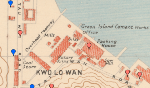
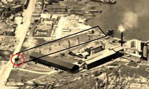
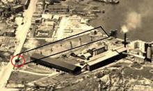
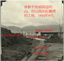
Overhead or aerial ropeway operated by Green Island Cement Company. It appears on the 1945 map on Gwulo and runs from a pier inwards. Originally the ropeway ended at Ma Tau Wai Road: See the 1945 map and a photo from about 1949.
And here:
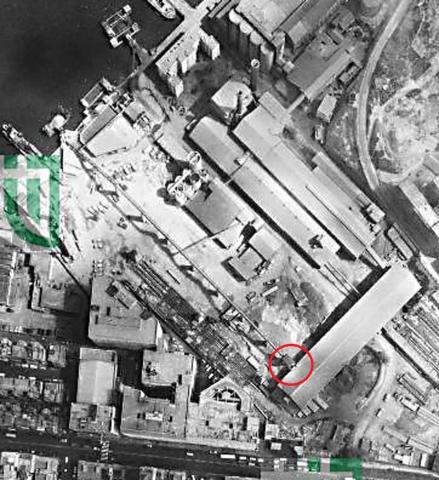
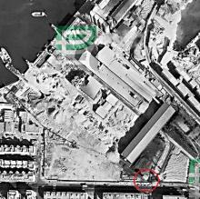
Between 1963 and 1969, the ropeway was shortened and ended at a a long stretched shed
See aerial photo from 1969.
It was probably used both for the transport of raw materials as well as products.
There is an article on industrialhistoryhk about this ropeway. It is referred there that it still stood there at the end on the 1960s, and perhaps longer.
Operation dates were (wildly) guessed to be 1945 to 1972.
Comments
ropeway
It did end at ma tau wai road. Just opposite the ma tau wai road-fat kwong street juncton.One can actually see the ropeway from ma tau wai road over a fence. More information here:
https://gwulo.com/atom/41885
re: ropeway
Thank you for the additional photos and information which helped to reconstruct the history of this ropeway.
history of green island cement (gic)
There is a gic web site which describes its history at:
http://www.gich.com.hk/sustainability.aspx
That page has a pdf file
http://www.gich.com.hk/values/protect_environment/sustainability/en/Pas…
which says something like this:
Green Island Cement Company Limited (“GIC”) is immensely proud to be one of
the oldest cement companies in Asia, first commencing business in Macau back
in 1886. Our historical footprint began with our original factory where barges
brought in limestone from Guangdong Province and loaded cement for export
to China.
GIC was then established in Hong Kong on 3 January 1887 and our second
plant in Hok Un, Hung Hom was opened in 1900............China Cement Company
(Hong Kong) Limited (“China Cement”) was formed in 1978 by
GIC, Kaiser Cement Corporation, Cheung Kong and a PRC
company with an intention to build a cement plant at Tap Shek
Kok and the plant was fully commissioned in 1983 when faith
in Hong Kong’s future and prospects was re-affirmed.
Green Island Cement (Holdings) Limited (“GICH”), our holding
company, took full ownership of China Cement in 1987 and
relocated its manufacturing facilities and operations from Hung
Hom to Tap Shek Kok in the same year, but with certain area
retained as our Directors and Sales Office.
Apparently the company was still active in Hunghom till the 1980s as the following 1987 news report shows a picture of some local legislators visiting their computer room of their Hunghom facility.
On the other hand, the Eldex industrial building which stands there now was built in 1971. There is some contradiction. One possible scenario is that the company sold part of its land near ma tau wei rd around 1970 as property price skyrocketed at that time but retained their manufacturing facilities.
https://www.spacious.hk/en/commercial/c/hong-kong/n/hung-hom/b/eldex-in…
Even today the company maintains an office near the east end of Hok Yuen street, in a building called Harbour center tower 2 built in 1990.
https://www.spacious.hk/en/commercial/c/hong-kong/n/hung-hom/b/harbour-…
portland house
In the above 1969 aereal picture, the first building from the right above the Ma Tau Wai Road was the Portland House (1964-1982), an industrial building. It was directly opposite Tsing Chau street. This picture shows the view from the west end of Tsing Chau street looking east.
==============================================
Further north after passing the Hok Yuen Street was a row of ancient residential buildings. One of them at 45j ma tau wai road collapsed in 2010. It is just out of the picture.
Re: Eldex Building
Land sale of parts of their site near Ma Tau Wei Road seems very reasonable. To achieve this, the ropeway was not just shortened, but also moved some 10 meters to the southeast. This can be seen on the photo below where the situation from 1963 is compared to the one in 1969.
The ropeway was moved closer to the productions halls/sheds. For better visualization, the track of the older ropeway is illustrated by the red line on the lower part of the photo.
1969 map
This is a merger of the maps 180 -SW-13 and 179-SE-16.They are from 1690, updated 1969.
On this map, two overhead ropeways are shown. Not clear if they were both active for some time, or only shown on this map.