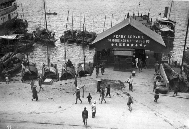
While this photo is dated about 1920, the building must have been operating into the late 1950s. Because I remember that little wooden booth on the front between the two entrances. The ferry I took was slightly larger and longer than the one shown here. The other pier to the left (west) also rings a bell. Thank you.
Moddsey notes that this Arthur Ball photo has a good view of the area, looking at the shore from the sea. (Click the 'All sizes' button to see the high-res versions and get a closer view.)
It's at the end of the war, so the Shum Shui Po pier looks to have been badly damaged, but you can still see the steps sloping down to the sea that are in the 1920s photo.
Arthur Ball's photo shows a small building on the shoreline next to the pier, which I assumed was to do with the trams' electricity. The 1936-46 map marks it as 'urinal', and in fact shows several dotted along Connaught Rd.
The pier to the west is marked as 'Yuen On Steamship Co. Ltd. P.P. No 17'. I think PP means public pier?
That small building, about 120 feet to the east of the ferry pier was likely a public washroom if my memory is correct. Walking westward from the pier for about one minute I would visit my grand-father who worked in a import/export office. And walking eastward, for a bit longer period, whould take me to the shopping area.
If I'm not mistaken one of those older building very close to the Western market as shown in the Bell's photos still exist today. I'll see if I could take a photo of it the next time I go there.
What has been happening to Connaught Road West and elsewhere in Hong Kong got me wondering. How does the law work in Hong Kong governing land-sea developments? These office buildings and homes have unobstructed view of the sea (and accessibility) and distant landscape and will see their value depreciate when new lands and buildings pop up in front of them.
There's no protection of your view that I'm aware of. In fact the opposite is true, that in most cases you could expect your sea view to diminish over time as taller buildings sprout up in front of you. The only exception I'd heard of was that there would be a clear corridoor left from the HSBC head office to the sea - but I'm not sure if that is an urban legend or based on truth.
Reclamation seemed to hit its peak in the 1990's. I used to have a copy of a government map of planned reclamations from that time, and it had reclaimed land sprouting in all directions. At about that time I met a british town planner who'd worked in Hong Kong for many years. He wasn't looking forward to returning to the UK after 97 - "Who wants new towns in the UK?". So maybe all that planned reclamation and construction was their last burst of creativity before being sent home to design bypasses?
I think that the 1990's were also a time when 'quality of life' issues gained a higher profile in Hong Kong. One of those issues was reclamation, and its turning point was the Protection of the Harbour Ordinance, passed in 1997 just days before the handover. Since then there is a lot more questioning of the need for further reclamation, with concrete results such as the withdrawal of the Green Island Reclamation plans. [See point 2.2]
So if you live on the seafront along Victoria Harbour, there's now a much better chance your view will be preserved.
Thanks MrB. In some way, it is better to extend the urban settlement onto the sea compared to altering wetlands and environmentally sensitive hillsides elsewhere. I tend to believe that the local residents and business establishment had little or no say in government's planning process in those days.
I am wondering if this photo was taken sometime past 1920s. I used this ferry service during the late 1940s and 1950s and the photo shows exactly how I remember it - the booth in the front, the short walk under the roof (the sides had opening enabling one to see the pier to the west), the sign on the wall. Could it be possible these stood unchanged for 30 or more years? And those wicker baskets. This very young boy looked inside and saw crabs in them.
I could be stretching my imagination if I claimed also that I once walked around that sink hole. But I can't rule our this possibility.
I think it could well have come from the 1920s. There are two maps of the area in the Mapping Hong Kong book from around this time. One shows the area in 1931, while the other was revised up til 1946. There are many differences between the maps in the Wanchai area, as the reclamation to Gloucester Road becomes built-up.
To the West though, there are few changes. The only big difference I can see is the appearance of the big Vehicular Ferry Pier on the 1946 map, replacing the two smaller piers, 'Fire Brigade Pier' and 'Ferry to Yau Ma Ti' on the 1931 map. Several of the other piers look to have changed owners, but other than that the area looks mostly unchanged.
Also remember that in the 1940's development ground to a halt during the occupation, and the focus immediately after that was on reconstruction, so it wasn't a time of great change.
Good question though. And thanks again for sharing the memories that bring these photos to life.
You are welcome, MrB.
I thank Batgung for posting these photos so that readers like me can relive the good old days. Indeed, the pase was slower in those days.
I think next to the wheel, the greatest invention is photography. Guess you never sleep by your computer and live next to the library.
It is correct that the Kau Lung Sze Yeuk Kaifong Ferry Company ran this ferry line
see Sham, W. C. (2007). The history of Hong Kong and Yaumati Ferry Company limited, 1923 to the 1970s (Master's thesis, Lingnan University, Hong Kong). Page 33 (here)
Comments
Likely the pier on Connaught
Likely the pier on Connaught Road in front of the Western Market building, as described here.
1920s Praya ferry pier
While this photo is dated about 1920, the building must have been operating into the late 1950s. Because I remember that little wooden booth on the front between the two entrances. The ferry I took was slightly larger and longer than the one shown here. The other pier to the left (west) also rings a bell. Thank you.
Pier in front of Western market
Moddsey notes that this Arthur Ball photo has a good view of the area, looking at the shore from the sea. (Click the 'All sizes' button to see the high-res versions and get a closer view.)
It's at the end of the war, so the Shum Shui Po pier looks to have been badly damaged, but you can still see the steps sloping down to the sea that are in the 1920s photo.
Arthur Ball's photo shows a small building on the shoreline next to the pier, which I assumed was to do with the trams' electricity. The 1936-46 map marks it as 'urinal', and in fact shows several dotted along Connaught Rd.
The pier to the west is marked as 'Yuen On Steamship Co. Ltd. P.P. No 17'. I think PP means public pier?
MrB
1920s Praya Pier
That small building, about 120 feet to the east of the ferry pier was likely a public washroom if my memory is correct. Walking westward from the pier for about one minute I would visit my grand-father who worked in a import/export office. And walking eastward, for a bit longer period, whould take me to the shopping area.
1920 Praya Pier
Hi there,
If I'm not mistaken one of those older building very close to the Western market as shown in the Bell's photos still exist today. I'll see if I could take a photo of it the next time I go there.
T
Land Reclamation
What has been happening to Connaught Road West and elsewhere in Hong Kong got me wondering. How does the law work in Hong Kong governing land-sea developments? These office buildings and homes have unobstructed view of the sea (and accessibility) and distant landscape and will see their value depreciate when new lands and buildings pop up in front of them.
re: Land Reclamation
Interesting question.
There's no protection of your view that I'm aware of. In fact the opposite is true, that in most cases you could expect your sea view to diminish over time as taller buildings sprout up in front of you. The only exception I'd heard of was that there would be a clear corridoor left from the HSBC head office to the sea - but I'm not sure if that is an urban legend or based on truth.
Reclamation seemed to hit its peak in the 1990's. I used to have a copy of a government map of planned reclamations from that time, and it had reclaimed land sprouting in all directions. At about that time I met a british town planner who'd worked in Hong Kong for many years. He wasn't looking forward to returning to the UK after 97 - "Who wants new towns in the UK?". So maybe all that planned reclamation and construction was their last burst of creativity before being sent home to design bypasses?
I think that the 1990's were also a time when 'quality of life' issues gained a higher profile in Hong Kong. One of those issues was reclamation, and its turning point was the Protection of the Harbour Ordinance, passed in 1997 just days before the handover. Since then there is a lot more questioning of the need for further reclamation, with concrete results such as the withdrawal of the Green Island Reclamation plans. [See point 2.2]
So if you live on the seafront along Victoria Harbour, there's now a much better chance your view will be preserved.
MrB
1920s Praya ferry pier
Thanks MrB. In some way, it is better to extend the urban settlement onto the sea compared to altering wetlands and environmentally sensitive hillsides elsewhere. I tend to believe that the local residents and business establishment had little or no say in government's planning process in those days.
I am wondering if this photo was taken sometime past 1920s. I used this ferry service during the late 1940s and 1950s and the photo shows exactly how I remember it - the booth in the front, the short walk under the roof (the sides had opening enabling one to see the pier to the west), the sign on the wall. Could it be possible these stood unchanged for 30 or more years? And those wicker baskets. This very young boy looked inside and saw crabs in them.
I could be stretching my imagination if I claimed also that I once walked around that sink hole. But I can't rule our this possibility.
Date of the photo
I think it could well have come from the 1920s. There are two maps of the area in the Mapping Hong Kong book from around this time. One shows the area in 1931, while the other was revised up til 1946. There are many differences between the maps in the Wanchai area, as the reclamation to Gloucester Road becomes built-up.
To the West though, there are few changes. The only big difference I can see is the appearance of the big Vehicular Ferry Pier on the 1946 map, replacing the two smaller piers, 'Fire Brigade Pier' and 'Ferry to Yau Ma Ti' on the 1931 map. Several of the other piers look to have changed owners, but other than that the area looks mostly unchanged.
Also remember that in the 1940's development ground to a halt during the occupation, and the focus immediately after that was on reconstruction, so it wasn't a time of great change.
Good question though. And thanks again for sharing the memories that bring these photos to life.
MrB
1920s Praya ferry pier
You are welcome, MrB.
I thank Batgung for posting these photos so that readers like me can relive the good old days. Indeed, the pase was slower in those days.
I think next to the wheel, the greatest invention is photography. Guess you never sleep by your computer and live next to the library.
More photos of the piers along the praya
We've received several more of that area. Start here, then use the 'previous image' links to see the rest.
between 1919-1924
In the photo, the ferry funnel looks like having "S" logo,
that means it is "Kau Lung Sze Yeuk Kaifong Ferry" running the services between 1919 and 1924.
Re: Kau Lung Sze Yeuk Kaifong Ferry
It is correct that the Kau Lung Sze Yeuk Kaifong Ferry Company ran this ferry line
see Sham, W. C. (2007). The history of Hong Kong and Yaumati Ferry Company limited, 1923 to the 1970s (Master's thesis, Lingnan University, Hong Kong). Page 33 (here)