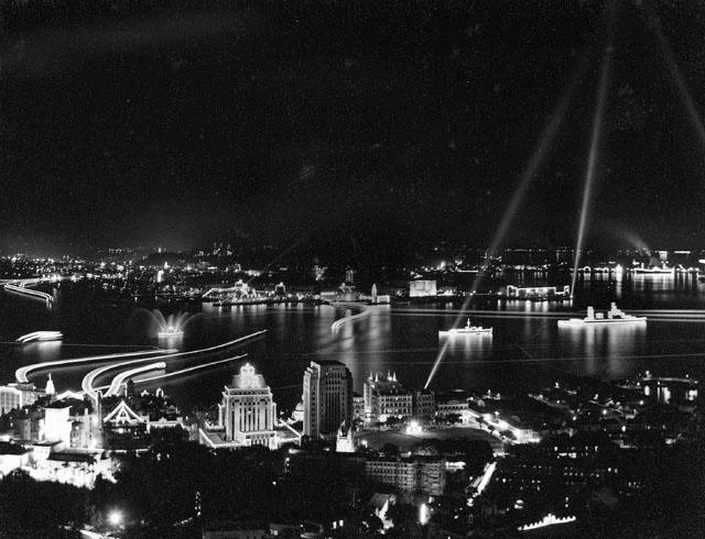
I wonder if that trail of light on the left was the Sham Shui Po ferry, which I used in the 1950s. Its dock was on Tung Chau Street near Kweilin Street, but I can't remember where exactly it docked on Connaught Road West. And when did its service ended? Thank you.
I am uncertain about the piers in the 50's, but as far as I could recall in the 70's, on the Shamshuipo side it should be somewere between the two intersections of Yan Chow Street/Kweilin Streen & Tung Chau Street. The YMT ferry on this route docks in Central Piers on the western side of the car ferry pier.
The western ferry pier was on Wilmar Street & Connaught Road West. That was supposed to be for Lamma Island routes.
Thank you T. The Wilmar Street looks about right as far as my memory goes. In those days, Connaught Road West was lined with import/export company offices and warehouses. I remember the coolies would pick up a big sack of rice and a wooden stick off the truck or boat, and next handed over the stick to another man upon entry to the warehouse. That's how they counted the shipment.
Likewise Tung Chau Street was located next to the water. Fishermen would come in on their small boats selling live seafood.
It appears several times on maps in the 'Mapping Hong Kong' book. First on the Kowloon side:
1947. Tung Chau Street forms the Sham Shui Po seafront, and the ferry pier is at the junction with Pei Ho Street.
1964. Unchanged.
1971. Unchanged.
1990. Shoreline has been reclaimed out to approximately the line of today's Sham Mong Road. There is a new ferry pier on the shoreline, roughly in line with Kiu Kiang Street. It looks as though it is still in use as a public ferry, as there is a bus terminus built next to it.
2006. The 'Hong Kong Guidebook' map shows the shoreline has been reclaimed again. The 1990 ferry pier is now the site of the Nam Cheong station, and Olympic station is just a little further south. Add in the new bus routes that pass through the western harbour tunnel, and it's not hard to see why the ferry went out of business.
Then on the island:
The 1930-45 Map shows two piers with services to Sham Shui Po. The first is between Eastern Street and Wilmer Street, and is marked 'Ferry to Tai O, Chung Chau, Yau Ma Ti, Mong Kok & Sham Shui Po'. The second is in front of the Western Market building, and is marked 'Ferry to Mong Kok & Sham Shui Po'.
1971. This map of the harbour still shows two ferry routes from Sham Shui Po. The pier nearer Central has moved and looks to be between Jubilee Street and Gilman Street. The Western pier has also moved slightly, and now looks closer to Sutherland Street.
1989. This map of the harbour shows just a single ferry route, reaching the island at the Jubilee / Gilman Street pier mentioned in 1971.
Thanks also to Soco who posted life in the Sham Shui Po area.
Re "classic" folding beds, the folding bed of the 1950s were a bit more classic, but also bulky and heavy. Both had wooden folding legs. The first type had 2 or 3 sets of foldable-cross legs at the two ends and at centre. The second type was more foldable to the meaning of the word. As one can fold not just the fabric but also each leg piece so that the whole thing could fit into a 9-inch by 9-inch by 30-inch (high) space.
Before sun rise, I walked past people sleeping on these beds on my way to catch the first of three buses to go to school. The beds with aluminum folding legs would come to the market later.
Comments
ShumShuiPo Ferry
I wonder if that trail of light on the left was the Sham Shui Po ferry, which I used in the 1950s. Its dock was on Tung Chau Street near Kweilin Street, but I can't remember where exactly it docked on Connaught Road West. And when did its service ended? Thank you.
Shamshuipo Ferry
Hi there,
I am uncertain about the piers in the 50's, but as far as I could recall in the 70's, on the Shamshuipo side it should be somewere between the two intersections of Yan Chow Street/Kweilin Streen & Tung Chau Street. The YMT ferry on this route docks in Central Piers on the western side of the car ferry pier.
The western ferry pier was on Wilmar Street & Connaught Road West. That was supposed to be for Lamma Island routes.
T
ShamShuiPo Ferry
Thank you T. The Wilmar Street looks about right as far as my memory goes. In those days, Connaught Road West was lined with import/export company offices and warehouses. I remember the coolies would pick up a big sack of rice and a wooden stick off the truck or boat, and next handed over the stick to another man upon entry to the warehouse. That's how they counted the shipment.
Likewise Tung Chau Street was located next to the water. Fishermen would come in on their small boats selling live seafood.
Sham Shui Po ferry
It appears several times on maps in the 'Mapping Hong Kong' book. First on the Kowloon side:
Then on the island:
MrB
PS Soco have interesting stories of life in the Sham Shui Po area.
Ferry photos
We've just received these: 1 2 3 4 5.
(Early) life in Sham Shui Po
MrB:
Your in-depth research always impresses me.
Thanks also to Soco who posted life in the Sham Shui Po area.
Re "classic" folding beds, the folding bed of the 1950s were a bit more classic, but also bulky and heavy. Both had wooden folding legs. The first type had 2 or 3 sets of foldable-cross legs at the two ends and at centre. The second type was more foldable to the meaning of the word. As one can fold not just the fabric but also each leg piece so that the whole thing could fit into a 9-inch by 9-inch by 30-inch (high) space.
Before sun rise, I walked past people sleeping on these beds on my way to catch the first of three buses to go to school. The beds with aluminum folding legs would come to the market later.