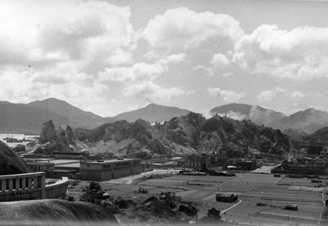
moddsey Tue, 05/01/2018 - 09:20 prevnextoldernewer Taken from Sacred Hill (Sung Wong Toi Rock) looking south towards Ma Tau Kok and To Kwa Wan. Hung Hom should be behind the hills Date picture taken 1935 Author(s) Moddsey Gallery 1930s Hong Kong Shows place(s) Sacred Hill / Sung Wong Toi [????-1943] Log in or register to post comments Comments That's a great view. I'm That's a great view. I'm always impressed by how high the hills at Hung Hom used to be. Log in or register to post comments Really nice photo. Is this Really nice photo. Is this angle further south than the village of Ma Tau Wei though since it shows the harbour? Log in or register to post comments Re: Photo I think one is looking towards Ma Tau Kok and To Kwa Wan. Have amended the title. Ma Tau Wei Village should be out of sight to the west of the Sacred Hill. Log in or register to post comments ma tau kok 1930 Same photo compared with today's google map with labels added. looking south from Sung Wong Toi Part of Sung Wong Toi can be seen. upper horizontal red line=ma tau kok st lower horizontal red line=mok cheoung st red line on the left=kowloon city rd A=ma tau kok slaughter house (currently an artist village) B=rope factory (became nanyang cotton mill after the war. Now residential buildings) C=tannery . ========================== ma_tau_kok_1930s.png, by simtang ============================== Log in or register to post comments
That's a great view. I'm That's a great view. I'm always impressed by how high the hills at Hung Hom used to be. Log in or register to post comments
Really nice photo. Is this Really nice photo. Is this angle further south than the village of Ma Tau Wei though since it shows the harbour? Log in or register to post comments
Re: Photo I think one is looking towards Ma Tau Kok and To Kwa Wan. Have amended the title. Ma Tau Wei Village should be out of sight to the west of the Sacred Hill. Log in or register to post comments
ma tau kok 1930 Same photo compared with today's google map with labels added. looking south from Sung Wong Toi Part of Sung Wong Toi can be seen. upper horizontal red line=ma tau kok st lower horizontal red line=mok cheoung st red line on the left=kowloon city rd A=ma tau kok slaughter house (currently an artist village) B=rope factory (became nanyang cotton mill after the war. Now residential buildings) C=tannery . ========================== ma_tau_kok_1930s.png, by simtang ============================== Log in or register to post comments
Comments
That's a great view. I'm
That's a great view. I'm always impressed by how high the hills at Hung Hom used to be.
Really nice photo. Is this
Really nice photo. Is this angle further south than the village of Ma Tau Wei though since it shows the harbour?
Re: Photo
I think one is looking towards Ma Tau Kok and To Kwa Wan. Have amended the title. Ma Tau Wei Village should be out of sight to the west of the Sacred Hill.
ma tau kok 1930
Same photo compared with today's google map with labels added.
looking south from Sung Wong Toi
Part of Sung Wong Toi can be seen.
upper horizontal red line=ma tau kok st
lower horizontal red line=mok cheoung st
red line on the left=kowloon city rd
A=ma tau kok slaughter house (currently an artist village)
B=rope factory (became nanyang cotton mill after the war. Now residential buildings)
C=tannery
.
==========================
==============================