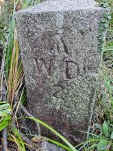
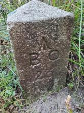
An interesting find. The "Broad Arrow" and letters B O refer to Board of Ordnance or simply Government Property. W. D. refers to War Department. First time I have seen "B O" and "W D" etched on the same stone. An old map may need to be referenced if one side of the stone was used for military purposes.
A discussion had made here previously on the origins of "B O".
That section of the map wasn't very accurately drawn, which is why the stone is shown a bit to the right of the marker. There was also a stone for the SW corner of the site, so that may have survived too.
Very delighted to learn in such great detail about this seemingly lost marker in the hills. I plan to return to the area, this time coming up from the S from Hk Trail Section 3.
According to your finding of WD2/BO23 , we find the rest of WDBS, but WDBS No1 was gone as they straight the Peak Road! please find the WDBS LIsting with location for your reference
WDBS LIST of the Military Sanitarium, by histricalwalkhk
WDBS LIST of the Military Sanitarium Part2, by histricalwalkhk
The boundary map of Military Sanitarium, by histricalwalkhk
Comments
Marker Names
An interesting find. The "Broad Arrow" and letters B O refer to Board of Ordnance or simply Government Property. W. D. refers to War Department. First time I have seen "B O" and "W D" etched on the same stone. An old map may need to be referenced if one side of the stone was used for military purposes.
A discussion had made here previously on the origins of "B O".
Good find!
I believe it's the stone that marked the SE corner of the boundary of the military sanitarium site: https://gwulo.com/node/18740
The stones are shown on the 1912 map of the Peak: https://gwulo.com/node/53138?a=1#16/22.2657/114.1632/Map_by_ESRI-1912_P…
That section of the map wasn't very accurately drawn, which is why the stone is shown a bit to the right of the marker. There was also a stone for the SW corner of the site, so that may have survived too.
Thank you for the amazing response!
Very delighted to learn in such great detail about this seemingly lost marker in the hills. I plan to return to the area, this time coming up from the S from Hk Trail Section 3.
so the time you came across
so the time you came across the stone was when you accessed it from Mansfield Rd?
did you reach it from HK Trail afterwards as planned?
I haven't had a chance to return yet.
There's also 3 Japanese Tunnel entrances there to explore, maybe in the dry season!
WDBS LIST of the Military Sanitarium
Dear MikeB,
According to your finding of WD2/BO23 , we find the rest of WDBS, but WDBS No1 was gone as they straight the Peak Road! please find the WDBS LIsting with location for your reference
Great update - Keen for more explorations?
Thank you for the detailed update.
Would you be interested exploring the 3 Japanese Tunnels in the area?