Current condition
Demolished / No longer exists
Previously I wrote:
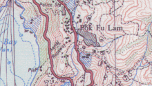
A 1957 map shows an Aerial Ropeway running from the Dairy Farm buildings near Pok Fu Lam Road, down the hillside and ending near a pier on the seafront, roughly where Bel-Air in Cyberport is today.
I can't see that map in the 'Mapping Hong Kong' book, so I guess it's a map I saw in the Central Library's map section. (Note to self: include references to sources!)
[2017 update, the ropeway is shown on the 1952 map.]
After Wednesday's talk, Ernest asked if I'd seen any photos of this ropeway. I haven't, but I have received some other information and tips:
- IDJ notes "... there is a book on Dairy Farm titled The Milky Way-History of Dairy Farm (1986) by Nigel Cameron. I'm sure the public library will have it."
- Paul Harrison recommends "Alan le pichons book on Bethany/dairy farm/ and nazareth press", and says the first ropeway in the area was for the Nazareth press, and it worked so well Dairy Farm wanted one too!
The Hedda Morrison photos (scroll down this page for details) would also be worth checking, as I remember she has some detailed photos of this area.
Regards, David


Comments
Additional sources
IDJ again:
Depending when it was built and in operation it may have been covered by PWD regulations in the same manner as cranes and lift's ropes having to be tested annually etc. So government's PWD arm should have had drawings of its construction and reports which may throw up something. Occassionaly reports turn up in bound volumes of 'Engineering', a UK journal from the 19th century onwards, on unusual ropeways and railways built in the colonies by British firms. I came across a brief mention of the Taikoo ropeway in one of them.
Adding back the map for easy reference
555B7675-DC25-43D7-8CAE
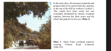
Present-day location of the ropeway from google street view
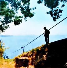
Dairy Farm Aerial Ropeway
Mention is made of the existence of the Aerial Railway in 1910 and the operations of the Dairy Farm here