Current condition
Demolished / No longer exists
Date completed
(Day, Month, & Year are approximate.)
Date closed / demolished
(Day, Month, & Year are approximate.)
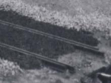
Old photos show a single track leading from the wharves across where the TST bus terminus stands today.
Photos that show this Place
1915
1915
1915
Comments
Circulating Area
It is here: http://gwulo.com/node/3228
That's the one - thanks!
That's the one - thanks!
The photos that have been
The photos that have been added recently show the rails were still in place through the 1940s but disappear in the early 50s. I've set a demolition date at c.1950, and will adjust as more details appear.
Latest posts and discussions
Latest posts and discussions can be seen here.
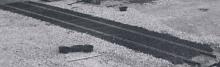
Railway connection to the
Railway connection to the Kowloon Wharves under construction in 1915. Likely these track opened at the same time when the terminus opened.
Re: Railway Siding to Kowloon Wharves
Now that http://www.hkmaps.hk/mapviewer.html is available online, the siding appears to have originated from 1934. Mention made here of the siding came from the 1934 Railway annual report from HKGRO. (I had originally typed in 1924 which I have since corrected). From the maps provided, the 1955 map of Kowloon was still showing the railway siding. Appears to have disappeared prior to the 1957 map.
The 1914 Railway annual report mentions the removal of tracks from Salisbury Road after the platforms of the Terminal Station were opened for traffic in April that year.
Re: Railway Siding to Kowloon Wharves
Hi moddsey, I'm still not convinced that the tracks were not in use from 1916 onwards. The photo from about 1914 show rails and sleepers on the prepared ground. The final surface is made by filling up with gravel and macadam to have the upper part of the rail at the same level as the road. The Public Works Report for 1916 states:
The area immediately in front of the station and to the south of Salisbury Road was made up to the required levels and macadamised, the necessary kerbing, channelling and footways being also provided.
This is also supported by the fact that the tracks appear in the 1922.1 map on HKMAPS.HK. I can't believe that the tracks were layed in 1914/16, then removed, and finally rebuilt in the 1930s.
The removal of track on Salisbury Road probably refers to the provisional station.
P.S. Can't open any of your photos you mentioned here.
Tracks
One of the two rails visible front left?
Re: Railway Siding to Kowloon Wharves
In the 1922.1 map, I think the map had been updated but not reflected as the bus islands outside Kowloon Star Ferry are clearly seen but are not visible in other maps from the 1920s. For the area under reference, the 1935 map looks to be the same as the 1922.1 map.
Yes, there are dead links in my previous posts from over ten years back but one of the photos that I had previously linked to is this one here which has been commented on. The railway siding should traverse the circulationg area at the NE end of the rickshaw rank but is difficult to discern. In addition, there are markings on the ground that do not help identification.
Dates of maps
One thing to watch out for on http://www.hkmaps.hk/ is that where a map is missing sections, the site will sometimes use maps from other years to fill in the gaps. In those cases, it isn't safe to use the map's year to date when buildings appear or disappear.
eg the description for the "1935" map makes it clear that it is actually a compilation of maps from two years:
Detailed plans for the urban areas developed and maintained by the Public Works Department. Compilation of 173 maps from 1922 and 1935
You can see it if you view the area of land where the TST bus terminus is, then switch between overlay maps 1922.1 and 1935. You'll see that all the markings on both maps are the same - i.e. we're looking at the same paper maps in both cases. From moddsey's comments above, I guess that the digital images used for that area of both the 1922.1 and 1935 overlays came from the 1935 paper map.
Re: Dates of maps
I also recognized that the sheets showing the bus terminus are the same on both maps (easy to spot from the dirt marks). Therefore I sent an email to the team of hkmaps to clarify from which year the maps are. I've checked some 20 sheets, they are all identical.
The reason why I'm so persistent is the fact that it's hard to believe for me that they build tracks in 1915, removed them in 1916, and rebuild them in 1934. But, of course, we don't know what really happened.
Re: Tracks
The rail service (British Section) commenced in 1910. Looking again at the 1914 photo of the temporary tracks, the tracks past the railway fence appear to be raised and not flush with the road surface. I note from above that a remark has been made of the 1916 PWD Report.
However, the 1914 PWD Report, Item 69 mentions: Consequent upon the laying-out of the new Passenger Terminal Station, the temporary Railway line, which was laid in Salisbury Road in 1910 was removed and the alignment of the road altered to meet the requirements of the Railway.
Been revisiting the maps at http://www.hkmaps.hk/mapviewer.html . Seems a new map has surfaced. The 1923 map shows a railway siding extending past the railway fence across the circulating area. Something to work on.
Re: Railway Siding to Kowloon Wharves
1913 Hong Kong and Kowloon Wharf and Godown Co. Ltd Annual Report See here (scroll to page 5)
"The acquisiton of this land (Police Basin) rounds off our property and gives room for a fourth pier, whilst the location of the railway terminus at our gates, must enhance the value of our land and has facilitated the railway siding into our premises."
From the above, the railway siding to Kowloon Wharves was added prior to the opening of the KCR Terminus in 1916
Re: Dates of maps
As pointed out above, I sent an email to hkmaps.hk. This is what Tymon Mellor answered (posted with his permission):
You have picked up on an issue with some of the detailed maps.
There are 168 maps published in the 1922 set, but only 5 in 1935, thus I filled in the missing maps with the 1922 set. This is not very good for people who wish to understand the date of the map. The attached map shows the location of the 1935 maps.
This is a bigger problem for the newer maps.
I have two solutions, if you look at the 1970 map, I have provided a graphic showing the date for each map element
http://www.hkmaps.hk/map_1970.1.html
The other option is to provide individual map dates and compilation versions, so you get the best of both works.
I'm in the process of preparing the these year maps and compilation versions so look out.
Hope that helps
Tymon
Railway sidings to the Kowloon Wharves
Now I believe that we see the construction of the railway to the wharves on the 1915 photo I posted recently.
More information about this here.
Connection to Kowloon Wharves in 1924
From: The Kowloon-Canton Railway (British Section) - A History (p. 72)
The report for the year 1924 includes:
That year saw the connection of the premises and wharves of the Kowloon Wharf & Godown Company to the British section by the laying of a siding across the circulating area in front of Kowloon Station.