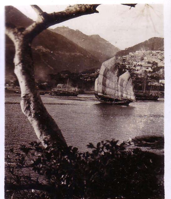
In fact that was my first impression when I looked at the photo. It appears to be the Chinese Permanent Cemetery at Pok Fu Lam/ Mount Davis which would place the photo more to the west of Aberdeen and closer to today's Cyberport. The photographer could have been standing on Lamma Island overloking the East Lamma Channel.
It looked very much taken somewhere near the location of the HK Electric Ferry pier in Apleichau to me. Probably before the Power Plant was built. From the background upwards one of the silhouettes at the peak looked like Mount Kellett to me.
On the middle-left along the coast line there seemed to be a temple of sort. Or a building looking like one of those typical Tin Hau temples along the coast. That appeared to be Tin Wan.
From the impression of the width of the channel I couldn't think of anywhere where else. I tried to use Google Earth and the terrain seems to match the view from Apleichau. I won't be able to check it out myself until this Weekend owing to work hour constrains. Unless, that is, I get up by day break........
I'll vote for the Aberdeen / Ap Lei Chau combination too. I couldn't work out the mass of "buildings" at first, so thanks for pointing out it is a cemetary.
The hillside on the left has a grey line running along it. I think that's the catchwater that runs behind the Tin Wan Estate - part of the Hong Kong trail runs along it.
I went about the phase one blocks of South Horizons and the seaside facing Aberdeen earlier in the afternoon and could not pin-point the exact location of where the photo was taken. However most of South Horizons was built on reclaimed land either by reclaiming the sea or blasting a bluff off and was formerly the site of a power plant, it is certainly difficult to tell.
However if you go and locate the newly published book 'Hong Kong in Old Times, A Collection of Aerial Photos Taken in 1964' (ISBN 962-567-185-4) , you should have some idea of where approximately the photo was taken. The photo for Aberdeen/Ableichau are pages 38 & 39. The two dry docks of the Whampao dockyards are clearly visible in the photo. I think during the twenty years between the 40' and the 60's, there wasn't much changed in the area.
I will send a photo or two taken in South Horizons towards Aberdeen later tonight.
Here are the photos. Only one was taken today. The other two was taken on a trip to Lamma Island earlier this year. The two unnamed photos showed a small temple at the sea side, right next to South Horizons/The HK Electric ferry pier. The temple appears to be located on the original shoreline, however from the look of it, it should be that old. I suspect that is a way to reach the temple on foot by a small foot path next to the Citybus Depot. However I am uncertain whether it would be blocked somewhere in the middle as there are still a few of those very small and privately owned dockyards located there.
Tom is correct. The old photo was taken from Ap Lei Chau across Aberdeeen Harbour. The hillside dominating the left side of the photo is Mount Kellett. The distant ridgeline with buildings silloetted on top is the south jutting spur to the east of Jardines Corner on which the Peak Police Station is situated. To its right, and still further away, is Mount Gough with Seven Road the light coloured line contouring around it.
Here's a photo taken today from Block 1, South Horizons, a little to the east of the original. That's Tin Wan opposite.
From South Horizons to Tin Wan, by gw
The 1939 1:20,000 OS map of the area shows a footpath running west from Ap Lei Chau Village, well above the shoreline, to approximately the place where the old photo was taken from. Perhaps the photographer was on the footpath.
Comments
Aberdeen
I guess the picture was taken in Aberdeen from the Ap Lei Chau.The background of the picture was the Chinese Permanent Cemetry.
Aberdeen
In fact that was my first impression when I looked at the photo. It appears to be the Chinese Permanent Cemetery at Pok Fu Lam/ Mount Davis which would place the photo more to the west of Aberdeen and closer to today's Cyberport. The photographer could have been standing on Lamma Island overloking the East Lamma Channel.
Re; Aberdeen?
Hi there,
It looked very much taken somewhere near the location of the HK Electric Ferry pier in Apleichau to me. Probably before the Power Plant was built. From the background upwards one of the silhouettes at the peak looked like Mount Kellett to me.
On the middle-left along the coast line there seemed to be a temple of sort. Or a building looking like one of those typical Tin Hau temples along the coast. That appeared to be Tin Wan.
From the impression of the width of the channel I couldn't think of anywhere where else. I tried to use Google Earth and the terrain seems to match the view from Apleichau. I won't be able to check it out myself until this Weekend owing to work hour constrains. Unless, that is, I get up by day break........
T
Aberdeen
I'll vote for the Aberdeen / Ap Lei Chau combination too. I couldn't work out the mass of "buildings" at first, so thanks for pointing out it is a cemetary.
The hillside on the left has a grey line running along it. I think that's the catchwater that runs behind the Tin Wan Estate - part of the Hong Kong trail runs along it.
MrB
Aberdeen/Apleichau Today
Hi there,
I went about the phase one blocks of South Horizons and the seaside facing Aberdeen earlier in the afternoon and could not pin-point the exact location of where the photo was taken. However most of South Horizons was built on reclaimed land either by reclaiming the sea or blasting a bluff off and was formerly the site of a power plant, it is certainly difficult to tell.
However if you go and locate the newly published book 'Hong Kong in Old Times, A Collection of Aerial Photos Taken in 1964' (ISBN 962-567-185-4) , you should have some idea of where approximately the photo was taken. The photo for Aberdeen/Ableichau are pages 38 & 39. The two dry docks of the Whampao dockyards are clearly visible in the photo. I think during the twenty years between the 40' and the 60's, there wasn't much changed in the area.
I will send a photo or two taken in South Horizons towards Aberdeen later tonight.
T
Photos of Aberdeen today from T
View across Aberdeen Harbour
Tom is correct. The old photo was taken from Ap Lei Chau across Aberdeeen Harbour. The hillside dominating the left side of the photo is Mount Kellett. The distant ridgeline with buildings silloetted on top is the south jutting spur to the east of Jardines Corner on which the Peak Police Station is situated. To its right, and still further away, is Mount Gough with Seven Road the light coloured line contouring around it.
Here's a photo taken today from Block 1, South Horizons, a little to the east of the original. That's Tin Wan opposite.
The 1939 1:20,000 OS map of the area shows a footpath running west from Ap Lei Chau Village, well above the shoreline, to approximately the place where the old photo was taken from. Perhaps the photographer was on the footpath.