There is a strap with the company name 公壽 on the coffin. The company still exist today and is located in Sheung Wan. Despite these service company would usually go wherever they are needed, I believe the photo was taken somewhere on HK Island.
Greetings. The words on the sign are read from right to left. My guess is that there are three lines with the top line showing the name of the shop/stall. On the second line, the far right word could be 開 (= open), so it would be grand-opening-big-luck, with the last word the type of orange popular during New Years. The last line literally says straight-pass (verb) -five-units. Regards, Peter
The shadows suggest the road/street is of a north-south orientation.
This is a corner of a very large retaining wall in the background with a characteristic dressed block wall with horizontal tie beams and drainage weepholes. The pavement seems to curve ‘up’ ever so slightly and this combined with a low barrier wall parallel to it may suggest it’s a bridge which may cross over a street or nullah below. Also the inclination of the stones on the retaining wall (to the left of the picture) slope downwards ever so slightly suggesting the inclination of the street/path/nullah below the ‘bridge’.
Can anyone now narrow it down further? Someone with an interest in Hong Kong architecture? Even though retaining walls are two-a-penny in Hong Kong...!
I noticed the 2 identical ads posted right behind the coffin.
They are related to a girls' secondary school called "陶淑女中學". The school was located at Shui Wah Fong(萃華坊), Fourth Street, Sai Ying Pun and I don't think this kind of ads about a secondary school would appear far away from its locality. So the photo was most likely taken in Sai Ying Pun.
There is an almost identical pillar at the junction of High Street & Pokfulam Road at the edge of St Pauls college. Part of the old retaining wall survives adjacent to the nullah that runs downhill under water Street While Google Street view is not clear it does not seem the horizontal tie beams in the surviving retaining wall match the original photo, however it is possible the road & bridge have been raised since the photo was taken.
Greetings. The current photos apparently show the same location, I suspect they cut off the top 10 inches (about) of the barrier wall and refinished the surface. The original block wall corner is likely still there but covered by concrete patching compound.
One thing puzzles me. The current photo reveals what looks like another layer of horizontal tie beam; however I cannot find simiarity in the block patterns between the old and new photos. Perhaps sharp-eye readers can help me. Regards, Peter
This 2014 photo shows the low-level barrier wall near the St Paul's College. Its corner cap stone appears to have the same design as the end one in the 1950's photo. On other cap stones, their bevals are similar. I tend to believe they show the same site and the same barrier wall. One lingering doubt is that the horizontal tie beams in the early and current photos do not terminate at a similar elevation relative to the end cap stone. Regards, Peter
It is very possible the nullah bridge parapet has been relocated further back away from the road when the road/pavement was widened. Below is a picture from the 1950s taken on the bridge but looking the wrong way and a map form the 1950s. The road/pavement layout has definitely changed with much less pavement in the 1950s.
1955 Map Hing Hong Road, by Crown Lands & Survey Office
It is also possible the that retaining wall was reconstructed during the rebuilding of St Paul's in the 1960s, however the wall seems unnecessary to the site so why rebuild it. I think it is more likely that the bridge parapet was moved.
one additional question: are you all fairly certain these photos come from the 1950’s? Even though the photos I have are all originals, I wonder if some might have been purchased from a cruise ship photo stock
Hi Kesayian, not an expert to answer your question but here are my thoughts:
1. The coffin appears to show the deceased hometown and name, I wonder if the funeral home (same still operating?) keeps records that far back.
2. Knowing the opening date of the girl's school might include/exclude 1930s as a possibility. The folder has another street photo which you suggest could be from the 1930s, and I assume your question also applies for this photo.
3. The two females wore clothes common in the 1950s but I cannot rule out 1930s; same with the posting of ads in public area.
4. If this photo was purchased from a cruise shop photo stock, then it could be any year. The quality of your several other photos (at least one showing water front) in the estate folder suggests that they could be from the 1930s, but this photo is of fairly good quality in my opinion.
5. How well did the deceased keep his/her diary/records. The two periods are 20 years apart so (edited: one possibility is that either he/she kept them together for simplicity, or) misplaced by the survirors/guardians.
Checking up the school Website, all the current school buildings (except the South Wing, which was done in 2003) were completed in 1969. So whatever being done the the retention wall and the whole lot (IL 7935) was likely sometime in the 1960's.
According to a BU research, there were 2 reistered schools bearing the name 陶淑 - 陶淑女子中學 & 陶淑中學校(To Shuk Middle School). Both were located in Sai Ying Pun. Don't know the relationship between them: a girls' school in the 30s and changed to co-ed in the 50s? 2 separate schools from the beginning? the girls' school still existed in the 50s after the war? If the girls' school vanished after the war, then the photograph would be more likely taken in the 30s or early 40s.
Address of the school 陶淑女子中學 was at 35 pok fu lam rd, currently site of Fung Lam building 豐林大廈, opposite Saint Paul college. It seems at top of picture, one can read parts of the Chinese characters "陶淑" and arrow saying something like go straight 5 more buildings???.
That means the spot in above picture was five buildings from Fung Lam building?
By the way, the Hkmemory article (see comment above) also mentioned the school was at Sui Wah square 萃華坊 which was some 3 stories high residential houses at the south-west corner of High st-Western st junction (currently site of Kensington Hill). Perhaps it is not a coincidence that there is now a building called Sui Wah House 萃華樓 next to it.
Of course the 35 pok fu lam rd address was in the 1930s. It is possible it later moved to Sui Wah square.
Comments
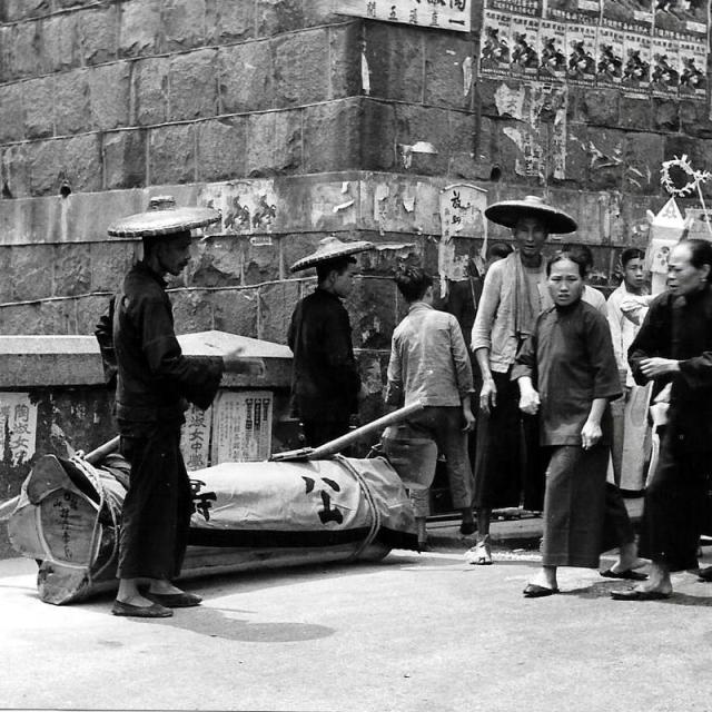
The two men on the left are
The two men on the left are carrying a Chinese coffin.
At the top of the photo is an arrow and Chinese characters, that look like a sign pointing somewhere. Can anyone read them and identify the location?
直過五間, need to see the top row
直過五間, need to see the top row to identify the place or location.
公壽 (Kung Sau Funeral Service)
Hi There,
There is a strap with the company name 公壽 on the coffin. The company still exist today and is located in Sheung Wan. Despite these service company would usually go wherever they are needed, I believe the photo was taken somewhere on HK Island.
T
Thank you all for your added
Thank you all for your added comments.
Karen
1955 street photo
Greetings. The words on the sign are read from right to left. My guess is that there are three lines with the top line showing the name of the shop/stall. On the second line, the far right word could be 開 (= open), so it would be grand-opening-big-luck, with the last word the type of orange popular during New Years. The last line literally says straight-pass (verb) -five-units. Regards, Peter
Other clues
The shadows suggest the road/street is of a north-south orientation.
This is a corner of a very large retaining wall in the background with a characteristic dressed block wall with horizontal tie beams and drainage weepholes. The pavement seems to curve ‘up’ ever so slightly and this combined with a low barrier wall parallel to it may suggest it’s a bridge which may cross over a street or nullah below. Also the inclination of the stones on the retaining wall (to the left of the picture) slope downwards ever so slightly suggesting the inclination of the street/path/nullah below the ‘bridge’.
Can anyone now narrow it down further? Someone with an interest in Hong Kong architecture? Even though retaining walls are two-a-penny in Hong Kong...!
I noticed the 2 identical ads
I noticed the 2 identical ads posted right behind the coffin.
They are related to a girls' secondary school called "陶淑女中學". The school was located at Shui Wah Fong(萃華坊), Fourth Street, Sai Ying Pun and I don't think this kind of ads about a secondary school would appear far away from its locality. So the photo was most likely taken in Sai Ying Pun.
See this news clipping from 'Hong Kong Memory": https://www.hkmemory.hk/MHK/collections/education/All_Items/Images/2013…
There is an almost identical
There is an almost identical pillar at the junction of High Street & Pokfulam Road at the edge of St Pauls college. Part of the old retaining wall survives adjacent to the nullah that runs downhill under water Street While Google Street view is not clear it does not seem the horizontal tie beams in the surviving retaining wall match the original photo, however it is possible the road & bridge have been raised since the photo was taken.
Re: it is likely a match
Hi There,
I was in the area this afternoon. It is likely a match but the retension wall may not be the same one. I have a photo here.
T
1950s Photo
Greetings. The current photos apparently show the same location, I suspect they cut off the top 10 inches (about) of the barrier wall and refinished the surface. The original block wall corner is likely still there but covered by concrete patching compound.
One thing puzzles me. The current photo reveals what looks like another layer of horizontal tie beam; however I cannot find simiarity in the block patterns between the old and new photos. Perhaps sharp-eye readers can help me. Regards, Peter
Pokfulam Road-Water Street
If the current photos identify the correct place, this is what the area looked like in 1882
1950s Photo
https://gwulo.com/atom/17740
This 2014 photo shows the low-level barrier wall near the St Paul's College. Its corner cap stone appears to have the same design as the end one in the 1950's photo. On other cap stones, their bevals are similar. I tend to believe they show the same site and the same barrier wall. One lingering doubt is that the horizontal tie beams in the early and current photos do not terminate at a similar elevation relative to the end cap stone. Regards, Peter
It is very possible the
It is very possible the nullah bridge parapet has been relocated further back away from the road when the road/pavement was widened. Below is a picture from the 1950s taken on the bridge but looking the wrong way and a map form the 1950s. The road/pavement layout has definitely changed with much less pavement in the 1950s.
It is also possible the that retaining wall was reconstructed during the rebuilding of St Paul's in the 1960s, however the wall seems unnecessary to the site so why rebuild it. I think it is more likely that the bridge parapet was moved.
Pokfulam Road photo
I would agree that it appears the road has been raised over time. Thank you for your research.
1950s photo
Thank you Herostratus and others for your explanations and help in identifying the photo location. Regards, Peter
1950’s photos (estate sale find)
one additional question: are you all fairly certain these photos come from the 1950’s? Even though the photos I have are all originals, I wonder if some might have been purchased from a cruise ship photo stock
1950's Photos
Hi Kesayian, not an expert to answer your question but here are my thoughts:
1. The coffin appears to show the deceased hometown and name, I wonder if the funeral home (same still operating?) keeps records that far back.
2. Knowing the opening date of the girl's school might include/exclude 1930s as a possibility. The folder has another street photo which you suggest could be from the 1930s, and I assume your question also applies for this photo.
3. The two females wore clothes common in the 1950s but I cannot rule out 1930s; same with the posting of ads in public area.
4. If this photo was purchased from a cruise shop photo stock, then it could be any year. The quality of your several other photos (at least one showing water front) in the estate folder suggests that they could be from the 1930s, but this photo is of fairly good quality in my opinion.
5. How well did the deceased keep his/her diary/records. The two periods are 20 years apart so (edited: one possibility is that either he/she kept them together for simplicity, or) misplaced by the survirors/guardians.
Regards, Peter
Re: time frame
Hi There,
Checking up the school Website, all the current school buildings (except the South Wing, which was done in 2003) were completed in 1969. So whatever being done the the retention wall and the whole lot (IL 7935) was likely sometime in the 1960's.
T
陶淑女子中學
This letter was dated Feb 16, 1951. The new campus was not yet built.
https://hk.auctions.yahoo.com/item/100659519731
To Shuk Middle School
According to a BU research, there were 2 reistered schools bearing the name 陶淑 - 陶淑女子中學 & 陶淑中學校(To Shuk Middle School). Both were located in Sai Ying Pun. Don't know the relationship between them: a girls' school in the 30s and changed to co-ed in the 50s? 2 separate schools from the beginning? the girls' school still existed in the 50s after the war? If the girls' school vanished after the war, then the photograph would be more likely taken in the 30s or early 40s.
address of girl school
Address of the school 陶淑女子中學 was at 35 pok fu lam rd, currently site of Fung Lam building 豐林大廈, opposite Saint Paul college. It seems at top of picture, one can read parts of the Chinese characters "陶淑" and arrow saying something like go straight 5 more buildings???.
That means the spot in above picture was five buildings from Fung Lam building?
By the way, the Hkmemory article (see comment above) also mentioned the school was at Sui Wah square 萃華坊 which was some 3 stories high residential houses at the south-west corner of High st-Western st junction (currently site of Kensington Hill). Perhaps it is not a coincidence that there is now a building called Sui Wah House 萃華樓 next to it.
Of course the 35 pok fu lam rd address was in the 1930s. It is possible it later moved to Sui Wah square.
Re:Photo
It is a very clear photo with a good level of detail. More likely postwar.
At top right, is that a film advertisement/poster for “Ivanhoe” or is it for something else? I don’t have access to HKPL/MMIS to confirm.