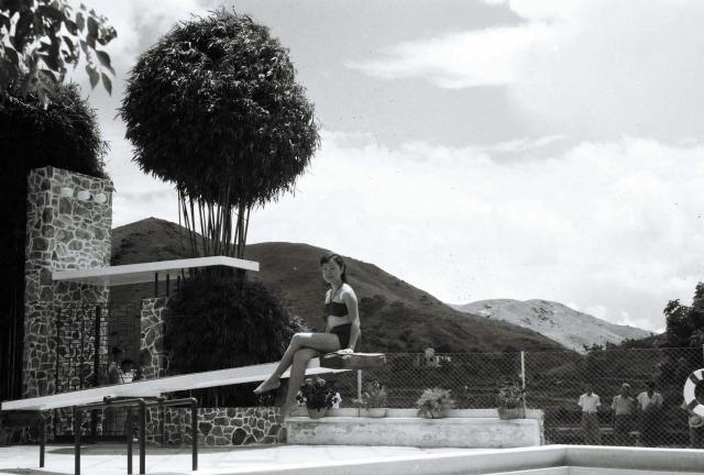
Greetings. I can rule out this as the economy swimming pools at Lai Chi Kok Amusement Park. Its "special" pool - which cost extra to use, higher quality fresh water, fewer users - is my strong candidate. The stonework on the wall also rings a bell. The adjacent landscape seems to agree with the 1952 contour map and that would be Eagles Nest farther to the northeast. The diving board, what a lovely memory of the camera man!
I have another memory of this place. It was getting dark and all the few swimmers were out of the pool. One young man and his friend ran past me looking for help as blood was streaming down from his forehead. He must have made a terrible dive. Regards, Peter
Hi Andrew, I remember this "special" swimming pool at Lai Chi Kok Amusement Park. Like many photos here, it is the seemingly mundane detail that helps us identify the site. In this case, it is the stonework on the wall (next to entrance not visible in photo) which I have long forgotten. It also reminded me of that "second" springboard attached to the wall, so at that moment wondering why it is up there; and the unfinished fence. For readers my generation, your photos are bringing our mind and heart back to those younger days. Regards, Peter
I don’t think that it was a second spring board. Zoom in and you can see that the bamboo seems to be actually growing up through the end of the white thing. There are no steps up to it, it is too far back from the pool edge for safe diving, and there is no sign of anything to provide the necessary ‘bounce’. Was it some sort of flat roof, maybe for a small pay kiosk? I think I can see an entrance just beyond it. A bit of a puzzle. Regards Andrew
Don't think it is the Lai Chi Kok Amusement Park. Looking at the hills behind, seems that the photo was taken at a high elevation. Perhaps a hotel or private club complex. Yes, it is indeed a puzzle!
Thank you Andrew and moddsey for the comments. I could be wrong in that this pool is not the one I have used or remember correctly its location.
The special pool at Lai Chi Kok Amusement Park was fairly new when this photo was taken. A lack of space and need for privacy could be the reason why it was located far back in the park, likely on newly expanded property. I remember walking uphill (about one minute my estimate) through open space with low shrubs and plants but no park structures or installations. This would be enough to place viewer on higher ground to see I believe Eagles Nest between two low hills.
I walked by this stone wall (entrance on left edge of this photo) to get inside the building, and on my second visit I got close to its front extension to see what they have planted. The “second” springboard was my initial puzzle but soon realized it wasn’t meant to be part of the pool. I have not used any other public pools, or got invited to private pool parties. The park and its pools were close to home with no competitions near by, and easily accessible by bus. So, my memories of these details give me no other alternative location. I have asked my siblings to verify its location. Regards, Peter
Back to the drawing board after viewing Peter's comments. Found the opening date of the Lai Chi Kok Hotel and Amusement Park and mention made of 2 fresh water pools. So this may be the photo reference.
Opening of Lai Chi Kok Hotel and Amusement Park, by Moddsey
Thank you moddsey for this 1947 opening annoucement. I believe the "two fresh water swimming pools" refers to the two pools (separated by a thin wall between them) shown in the photo below this note. My family and I used the smaller pool in early 1950s. They were located very close to the beach.
Their third pool is the one shown with the springboard girl, and was located a distance uphill from these two. I estimated it was built about the same time when I was using the small pool. Regards, Peter
On the right of this photo, there appears to be an opening between two hills such that from the third pool with the springboard girl, one can see the peak of Eagles Nest to the east -
Noted with thanks. Not sure where the hotel was or whether it had a swimming pool. If one is able to line-up the hills on google earth, one may be able to solve the puzzle. Here is the view up the hill.
Peter - can you remember how high up the pool was? I'm having a hard time trying to reconcile this view with the easterly view from Lai Chi Kok. Perhaps this is a view looking in another direction?
There appears to be some rice terracing on the hill behind the wire making me think this could be the view to the north? But it's hard to determine.
An interesting investigation. I was interested to see that the admission charge was 30 cents. If that was for a day, it would seem to represent very good value. Was that how it seemed to most customers in the early 1950s?
Malcolm's photograph of the unusual building that started it off is definitely the one at the extreme left on the two photgraphs above. On the top one, it looks very much as if the developer had required the builder to make it look like a passenger ship - the row of balconies along the side would not be out of place on a modern cruise ship, albeit a very small one! I have a strong ecollection from the 1980s that a small block of flats/offices(?) somewhere close to the then harbour front in the Hung Hom area of Kowloon was also built to resemble a ship, with the 'bow' facing the harbour as if the 'ship' was about to be launched.. It was probably on the site of the old Whampoa dockyard. Is it still there?
I have just trawled through my 1980s photographs and the historic Google Earth images but cannot find the image that I recall seeing. Perhaps, it's a good job as I wouldn't want to defile the Gwulo site! Andrew
Perhaps one day when it has been demolished for housing we can consider it as a proper part of HK history and worthy of inclusion. Until then, here you are.
Thanks Phil. I'd forgotten just how realistic it is. Yes, it might be incongruous in its setting but one has to admit that it is very unusual and might one day be missed - almost as if they had demolished the Eiffel tower in Paris when its original purpose had been served. What is it used for these days? Regards, Andrew
For the whole time I have been here (so at least 13 years now) it has housed a cheap Japanese supermarket called Jusco, which recently changed its name to Aeon. I understand Li ka Shing had it built when Whampoa was being redeveloped as a reminder of what used to be done here. I guess it is fairly quirky. I think more could be done with the actual structure because I think you can only explore the basement. They should make the upper part of it into a bar :)
Dear folks, thank you for your interest and support.
Phil, I think this pool is about 40 feet higher than the two other pools. Walking uphill was not difficult but still needed some effort, no more than two city block distance-wise. Because we could start our walk from inside the amusement park, us boys always called it their (meaning the park's) special pool. As moddsey suggested, it might have been operated by a hotel but I don't remember seeing any sign for it.
Where the men stood on the other side of the fence, I believe that was the dirt road running north by the park in moddsey's photo. Getting a distant view now is not possible due to the tall vegetations.
North of the current Princess Margaret Hospital, more precisely at Kwai Chung Hospital, there is a Google drone view. Assuming its pin is precisely placed, looking to the southeast, one can see two overlapping ridgelines with the distant one slightly higher. Could they be the same ridgelines in this photo (with springboard girl), where the low spot beyond the fence made viewing them possible? Since the pool was to the southeast of the drone, and was at a lower elevation, the change in the two ridgelines seems to support this idea. I welcome corrections and any new discovery.
Reply from my sister - “This is the special pool which cost extra to get in (50 cents.). I think outside (economy pools near the beach) was 35 cent. I visited the house behind this pool. My school mate from St Mary's lived with her family. I think her dad was a high ranking Lai Chi Kok park employee.”
My main memory now leads to other bits and pieces – Along the back/north perimeter of the amusement park, they had a simple low barrier which you could jump over or walk under to get outside. There was a narrow opening where a path to this pool began. It had no gate or guard, except a sign written in such a way saying where the path ends so as not to encourage misuse or inquisitive park-users. The incline was easy to walk at first, then the slope got steeper as one got closer to the pool.
Regards, Peter
Correction - May 16, 2019: The path that started at the back/north side of the park ran uphill and northward. As shown in other photos, there was a rural road running along the east side of the park. This piece of memory has just returned - after walking uphill for a distance, the path turned east and I walked up a steep embankment to cross this rural road to the east side where the pool was located. This puts the pool at an elevation higher than I had estimated, on the left in the photo below.
Klaus' recent reference to the 1963.2 air photo - https://www.hkmaps.hk/mapviewer.html - has reignited my interest in locating the site of this photo.
{C}{C}{C}Springboard Girl Tri-Photo (1952), by OldTimer{C}{C}{C}
The 1952 pool was on the south side of the building marked A. Its one side is parallel to the building's facade, and one corner pointing to the east - the two distant peaks in the photo. From this pool, Trousdale was able to take another photo but looking to the north (note springboard girl under the umbrella).
{C}{C}{C}Swimming pool., by Malcolm Trousdale{C}{C}{C}
This pool is not visible in the 1963 air photo because it was demolished sometime after 1952 to make room for a bigger building.
The 1963 air photo shows a pool on the west side of the building parallel to the property line, and parallel to the verandah of the next house. Trousdale's north-view photo shows "his" pool is not parallel to the verandah.
Estimated location of the first pool:
{C}{C}{C}Springboard Girl Pool Locations 1952 and 1963, by OldTimer{C}{C}{C}
If the above discussion is correct, the peaks in Trousdale's east view photo are Piper's Hill and Eagle's Nest. The peaks (names unknown) in his north view photo are the current Tai Wo Hill (236 m and 256 m in the 1952.1 map). The 1952 pool was few steps southeast of today's "Greenwood Vilas Phase 1 Block B". Like many places in HK, it is impossible to see the distant hills again from ground level.
About the place - It was not a typical residential building in this rich community. It was operated by a senior staff from the Lai Chi Kok Amusement Park, thus a much larger pool. When the park opened in 1949, one ad mentioned their hotel accommondation which I think is the place they referred to.
Comments, discussions and corrections are welcome. Regards, Peter
Added (same day): I swam in this pool several times in 1955 and 1956. The trips started at the rear of the amusement park where they had a simple low level fence and an unlocked gate. My sisters and I walked uphill through the open field, turned right (east) where the ground became steeper, very steep up the embankment to this rich community. There were fewer houses compared to the number shown in the 1963 map. We walked clockwise around the area to reach the pool.
One man at the entrance charged a very small fee for using the pool.
My older sister was our guide. Her classmate was living next door - the house with the verandah shown in Trousdale's photo, hence our connection to the pool. I remember the stonewall and the front door to the left of it. Inside, there was a reception desk with one staff serving their guests / residents.
Thank you for an excellent piece of detective work, Peter. Using the various images and your own memories of going there in the early 1950s, I am sure that you have now positively identified where the Spring board pool was. I guess that Malcolm, who took that photograph, would not normally have had easy access to it. Perhaps somebody down in the amusement park suggested that there was a 'better' pool up there and at a guess the girl on the springboard might have been there as part of a publicity event. That would certainly have intrigued Malcolm enough to go up to that pool and see what was going on. Regards, Andrew
I think this location places the pool too close to Castle Peak Road. The slope on the other side of the road is too high to allow any view to the east from there and I'm not sure the image matches the view to the northerly or southerly directions from there either. You can use Google Streetview on that part of Castle Peak Road today to see exactly how high the hill is on the other side of the road and how it would prevent any view towards Eagles Nest from there.
Thank you Philk for the feedback. Your comments add new information which will ultimately help lead us to the correct site.
Some parts of my memory may be inaccurate. But this is 100% certain - after climbing up a steep embankment, I walked a short distance to the northeast, around a street-end clockwise, next passing very few houses, before reaching the building on the left (north) side of the road with the pool. This means the building was either on the middle row of the three rows, or on the east row, either the last one or second last unit.
As most of these houses were facing southwest and more towards west, and the pool was in front of the building, very few were able to provide a simultaneous view of the pool, the building and the spur on the east side of the road. I think matching the spurs between two photos is the key.
The on-lookers could be standing farther away and below Castle Peak Road. This would place them in the middle lane, last building. But there was apparently no walk path between this lane and Castle Peak Road, and I wonder how the men knew about this place.
Trousdale's photo shows next-door's verandah - it looks like the white spot on the 1963 photo - leading me to rule out other houses on the north lane.
The nearby hills on the east side were not very high relative to Castle Peak Road, and their side-slopes form a valley-like window to the distant hills.
I did try to view the hills from Castle Peak Road on Google. It was impossible, not even from a double-decker bus. There are no current street views from the north lane, but I think its set back from the low hills was far enough to give a view farther to the east in 1952.
It would be great if we could locate a phone book, or the park's directory, that shows the address and map location of their hotel. Regards, Peter
Perhaps this other image from Malcolm might help. The houses on Chung Shan Terrace can be seen in the background on the left. Castle Peak Road is running behind them on the flat ground above the property roof lines.
Thank you Phil for your help. Castle Peak Road was indeed running at a higer elevation than all the roof tops. And similar today in Google street view which shows the first building at the junction with Chung Shan Terrace.
My original thinking was based on the assumption that it was possible to look to the east because of the opening between two low hills just on the east side of the Road. I was also attracted to that spur marked B. That bowl-shape like contour is still there on the east side of the road - the photo with the double-decker bus. Take away the current about-25 feet high trees, I cannot prove either way about visibility to the east.
Now, allow me to propose another theory. The springboard girl pool is shown in the 1963.2 pool, still assuming the first house from the Road. A close look at the photo shows that the pool is not perfectly parallel to the hotel building. The space between the pool wall and the building is smaller at the left end (out of photo on the left), and is a bit larger at the right end (shown in the springboard girl photo). The men took a short walk down from the Road.
Next, I suggest that Malcolm was looking southeast when he took the photo. The big spur marked C, not visible in my tri-photo, is now shown in Trousdale's photo. The hill behind the men would be that next to the amusement park. The peaks in the distant would be those at Lai Chi Kok but I cannot get them matched. The 149 m peak? The other Trousdale photo, I assume, was still looking north. Would this theory hold?
Regards, Peter
June 14 photo added : scope assuming camera looking to the southeast. Redines represent the left and right edges of photo, and not all features in the map/air photo can be seen due to changes in topography.
I have read all your posts with great interest. Between you, you have arrived at a solution that must be more or less the correct location for the place from where Malcolm took the photograph of the girl on the springboard.
One or two questions, that none of us can answer, relate to Malcolm's visit to Lai Chi Kok. In another conversation about a photograph that Malcolm took at the Castle Peak Police station, correctly identified by some of you, I speculated that Malcolm, like my pal and I, did the 'circuit', or in his case part of it, of the New Territories. We know that, as well as Lai Chi Kok, he photographed the Castle Peak Police Station and Tuen Mun in San Hui. However, significantly, he also took a photograph of a bus station that Peter has identified as the Jordan Road bus station. A destination board on one bus clearly shows Lai Chi Kok, so I believe he probably went by bus from the Star Ferry pier at Tsim Sha Tsui and transferred to the Lai Chi Kok bus at the Jordan road bus station. This bus would have taken him to the large bus terminus down near the beach. Once or twice I travelled by bus directly to Yuen Long via the Castle Peak Road and my bus definitely did not go down to the Lai Chi Kok beach. As well as taking one or two photographs down at the amusement park Malcolm must have climbed a hill on the west of the bay to take photographs overlooking the beach and complex from up there. If, as I have suggested, he then decided to travel further along the Castle Peak Road in the direction of Yuen Long, he would probably have asked the way and then climbed up to the Castle Peak Road to catch a bus there. It is therefore very likely that he would have walked past the house where the pool was and seeing the beautiful girl on the spring board he would have taken her picture. It's all conjecture but, otherwise, why would he have gone up there? Regarding the New Territrories 'circuit', Malcolm was a keen and good photographer, becoming a professional photographer in later life, but he took no photographs of Yuen Long, Kam Tin or Taipo Market, which I found of great interst, so I do not think he made the complete circuit. Any thoughts? Andrew
I'll be back in HK and out of quarantine in a few weeks (I hope) and will make some effort to head over there (it's in my neighbourhood) to see if I can match any of the surrounding mountains.
Thank you Phil for your help. Referring to the springboard girl photo, the building in the background might be a clue. The 1963.2 air photo shows what appears to be a building on the east side of Castle Peak Road, about 100 metres south of the Chung Shan Terrace. The line just above the four flower pots, that looks like the curved ramp to Castle Peak Road (assuming it is Castle Peak Road). Have a great trip coming home to Hong Kong!
Malcolm, I guess the photo was taken on grand-opening day of the swimming pool. The chain-link fence was a temporary safety measure.
I am increasingly coming to the conclusion that Peter's suggestion that Malcolm took the photograph of the girl with his camera pointing to the South East, more or less in line with the red line that Peter has drawn on the 1952 map and the 1963 aerial photograph. In that case, the small group of men watching from behind the chain link fence would probably have been standing on the narrow road that led from the Castle Peak Road (CPR) down to the houses. A narrow white band can be seen running across the image behind the legs of the men.and that is probably the narrow road However, if the house in question is the one at the right hand end of the uppermost road of houses, as seems to be agreed, the map and aerial photograph indicate that the CPR was only just behind that row of houses. I have looked at Malcolm's other photograph taken from the far side of the Lai Chi Kok but cannot make out the house with the verandah where Peter's sister's friend lived, which on the spring board photograph seems to be quite close by. Am I looking in the right place?
I'll now add an enlarged and hopefully enhanced part of my file photograph, showing the appropriate row of houses, to Malcolm's gallery, and then insert it below. Perhaps it might be of use? I have also made an even larger enlargement, showing just the row of houses, but it has a very low resolution of about 46kb, so it is probably of little use. Andrew
Malcolm image Lai Chi Kok enhanced a.jpg, by Andrew Suddaby
Thank you Andrew for enlarging the Trousdale's photo. See if this makes sense ...
West of the amusement park, there is a mini peninsular extending south. From the front of the park, he walked on the road westward, and at the first bend, he took the photo looking to the northeast. He might have climb all the way up to the ridgeline to take the photo but it seems to be too high in the photo.
The first building on the right appears to be the one with the pool. It is on the far east lane. To the left of it is, relatively speaking, a bigger and taller house, and it is on the middle lane. It blocks the camera's view to the gap between the two buildings on the east lane, hence it could not capture the verandah. Besides, the verandah was not high enough to show itself in the photo.
A few seconds of memory, dormant for 66 years has come back. In front of the swimming pool building alone, I looked to the east to that ramp leading the Castle Peak Road, quiet, low vegetation. I have a personal interest in these Trousdale photos.
I first thought that the park's northern pair of pools could have matched Malcolm's photos - possibly a small, deep diving pool, with a larger, shallower swimming pool next to it. But I can't match up the backgrounds of his photos with the layouts shown in the maps and aerial photos - eg the fence and open land beyond the springboard girl, or the lack of buildings behind the 'swimming pool' view.
Fingers crossed Phil will have better luck with the skylines.
I have just posted a reply on the link that appears on David's comment above but, in order to keep this thread going, I am also inserting here the photograph taken by Malcolm Trousdale of the peculiarly shaped and shiny ship-like building, which I believe somebody suggested was either a hotel or restaurants. The pools marked blue on the map on the other thread don't seem to have any sign of a springboard, or of the narrow roof with the bamboo(?) growing through a hole in it, or of the very distinctive 'crazy paving' walls. Peter's strong memory of the springboard pool is of it being at one of the houses way up on the hill quite close to the Castle Peak road. Andrew
Weren't at one point those buildings on Chung Shan Terrace or nearby buildings in this area served as housing for the families of the British arm forces?
Hi David L, I don't know about the origin of this place. It is possible, the houses were big on large lots, of western design, and offered excellent view to the sea. My experience there was brief, several visits to use the pool in 1955-56. They did charge visitors a small amount for using the pool, and the interior layout did not look like a family home to me. Perhaps this building was an exception.
I think I wrote about this event on another link.... It was getting dark and closing time, I was standing near the springboard (but no girl there) when two men ran by me. One of them was bleeding badly from his head. It appeared that he decided to make a dive one more time from another spot. They were looking for medical assistance but this was a remote place and if lucky, the clerk might be able to help or offer advice. Looking back I don't think it was a good idea to run around with such injury. A few minutes later, I saw some blood stains on my arm. I hoped he was ok. Another reason to not forget this place. Regards, Peter
Thanks to Monika Hendry on Facebook for identifying the location as Yick Yuen at Pak Ngan Heung in Mui Wo. The pool and gate are still there today and easily recognisable:
Brilliant!. Glad to see our suspicions of another location finally confirmed (and saved me a trip). The distant hills therefore are the Man Kok peninsula located on the north side of Silvermine Bay. Amazing to see that the gateway is basically unchanged after all these years.
Thank you all for starting a new round of discussion based on new information. This is indeed a big surprise and I am ready to admit fault.
According to my memory, the stonework in Trousdale's photo is part of the wall of a building. To the left of the stonewall there was a door leading inside to the clerk's desk. His camera was looking from the pool, through the gate, to the outside, and captured the spur I marked "C", which seems to match the feature on the 1952 contour map.
At Yick Yuen, the street view is looking from the outside to the inside including the pool. I have never been to Yick Yuen, and I was puzzled when I compared the stonework(s) between the two photos. The stones match. I can think of one possibility. When they demolished / renovated the building by Castle Peak Road, they moved the stonewall to the new site. Notice in Trousdale photo the stonework extended towards the pool at a lower elevation (I rememer very well standing next to it). They got surplus stones so they built a low level wall at the new site. This is specalation I admit. They would need to box the wall with lumber before transporting it in, I assume, a flat bed transport, but some spots broke loose either during demolition or transport, hence the difference finishing at the new site.
Now, on the spur named "C". I tried to look for it walking back and forth to find a window to the east at Yick Yuen. The land seems to drop off to the east.
Based on rough comparison, the distance between the pool and the wall is larger at the Yick Yuen site, not by much, but I think this difference is there. The other Trousdale photo showing a verandah could not be duplicated at the Yick Yuen site. There looks like a small difference in the pool's inner wall between the two.
The white overhead boards above the gates are about 10 feet away from the pool in Trousdale's photo, and about 13 feet at Yick Yuen, with the latter not lining up with the pool's side as good as that in Trousdale's photo.
So, I respectfully cannot at this time agree that Trousdale took his photos at Yick Yuen. I have been wrong before and will welcome corrections. Regards, Peter
Yick Yuen is owned by the Yeung's, of Yee Woo Loong Rice Trading Company Limited. As the site is private, I wonder how the photographer got in. Maybe he know the owner or was invited as a guest of sort?
In the background behind the middle flower pot appears to be either a large grave or House. It does not seem to appear in the Castle Peak aerial photo?
What a fascinating dialogue this has become - and all from one old photograph! Thank you all for your interest.
Seeing the Google map image of a concrete 'canopy' with the bamboo(?) growing out of it on Lantau adds a truly amazing dimension to the saga. In 1952, when Malcolm Trousdale took the photograph or in any of the years between 1946 and 1962, when the 367 unit was in Hong Kong I know of none of my R.A.F. colleagues going to Lantau. Nobody has ever mentioned visiting Lantau between those years and the only reason for going there would have been to visit the monastery, which would have been a firm memory for anyone. Malcolm would certainly have photogaphed that. Cheung Chau was the only island that I have any evidence for our visits. Malcolm's photographs certainly show the Lai Chi Kok complex and, with other images in his collection, indicate what the more adventurous amongst us did in doing the circuit, or part of it, round the New Territories. I am not competent to comment on the topography behind the Springboard girl image or, indeed, its location but my best guess is that it must have been taken at the time when Malcolm visited Lai Chi Kok. Going there in itself was a bit unusual. It was off the beaten track and while there is evidence in the 367 Association archive that another colleague went there to play in a water polo match, there is no evidence that Malcolm did. If he had done he would almost ceretainly have taken a photograph actually on the swimming pavilions.
Where does that get me? Bearing in mind the other photographs almost certainly taken on Malcolm's day out into the New Territories and Peter's memory, I find it very unlikely that a very heavy structure like that photographed by him in 1952 would have been carefully dismantled and carted all the way over to Lantau and taken up the hill behind Silvermine bay. More likely, somebody living on Lantau saw the unusual structure at the Lai Chi Kok complex and built a more or less identical one on Lantau. I'll look forward to seeing more on this very puzzling topic. Andrew
The invitation to visit the house came about in 2019 on the 3rd day of Chinese New Year via a friend of a friend. So essentially pure luck to get in and was able to spend one whole day there to appreciate the house itself which I think has some Japanese influence? The grounds were amazing - lots of old trees and stuff and a lot of camellia in full bloom as well. A descendent of the owner of the house actually told me the family fled to the house during the war years, but some of the architecture actually looks post-war, so I guess the estate may have been rebuilt or altered at some stage?
Thank you all for the support and ideas about the actual location of the springboard girl photo. Here, I am not making counter arguments, but only to provide my current thinking about this issue.
There was, I believe, some business / ownership connection between the building by Castle Peak Road (CPR) and Yick Yuen. The one by CPR was operated by one high level employee at the Lai Chi Kok Amusement Park (Lai Yuen another name). He might be the same person who later moved away and operated the site later known as Yick Yuen.
Relocating the stonewall might have been a part of his venture. The deterioration of the stonewall at the current Yick Yuen site is unusal, from very poor in some spots to perfect conditions at other spots near the base. This led me to believe, only to keep my story alive, is that it was a poorly salvage, packing and transportation process.
In the 1963 air photo, it is not possible for me to spot the stonewall and gate. There was a line of vegetation that ran almost perfectly in north-south direction. I don't think that's where the gate was. The current Google street view shows that the gate is an extension of the shrub-line running from the north. This would place the gate in the northeast-southwest alignment. So when a person looks to the outside, through the gate and perpendicular to the gate, he would be looking to the southeast. Turning 180 degrees he would be looking to the northwest - much the same alignment of the north pool wall. Notice where the springboard was located, but it is not an issue for me.
I try to match what an observer would have seen through the Yick Yuen gate with the landscape shown in the Trousdale photo, but so far am not convinced enough. East of the Yick Yuen pool, the ground slopes mildly down towards the rice paddies. There is a spur to the east, but I don't think it matches better than the one south of the CPR junction. And the small hill behind the men, I still try to find it in the 1963 photo.
Trousdale might have indeed visited this place in 1952, but my belief up to now is that the stonewall and the gate did not arrive on site until after 1963.
Thank you all for your patience, much appreciated. Regards, Peter
Yick Yuen 1963 Photo and 1952 Map.png, by OldTimer
Thank you all for so many interesting comments on what at first sight was just a nice photograph of an attractive young lady on the springboard. There is another thread concerning a second of Malcolm's photographs of a swimming pool - probably the same one, and perhaps it would be easier to follow this discussion if they were actually just one.
However, having carefully re-read the correspondence associated with all Malcolm's photographs. I now know, contrary to my own thoughts, that Malcolm did visit Lantau, so my apologies for any confusion that my previous comments might have caused. In 2019, I belive it was Phil who spotted the same building with a cross on it on one of Malcolm's seashore images that also appeared on another's image with Lantau as the known location. So, in keeping with recent comments by Phi and Geoffrey, I am now convinced that Malcolm's Springboard girl photograph was taken on Lantau - but I have not been able to find the two 'street view' images on Google Maps that have now been added to Gwulo. Now, my question, which is probably unanswerable, is why did Malcolm go to Lantau and take three or four photographs, two down on the shore and two way up the hill at what must have been rather a remote house, specifically(?) on the day when an attractive girl was posing on the springboard? Did Malcolm know the girl or the family who lived there? Nothing beats a good mystery!
Peter certainly visited a pool at one of the houses up above Lai Chi Kok, as he has had confirmed by his sister, and one must wonder whether there was a similar pool up there. Andrew
I managed to dig out this photo of myself from my wife's phone. I can imagine that the bikini clad woman would be directly above me now if the springboard is still in existence?
Comments
Lai Chi Kok Amusement Park - possibly
Greetings. I can rule out this as the economy swimming pools at Lai Chi Kok Amusement Park. Its "special" pool - which cost extra to use, higher quality fresh water, fewer users - is my strong candidate. The stonework on the wall also rings a bell. The adjacent landscape seems to agree with the 1952 contour map and that would be Eagles Nest farther to the northeast. The diving board, what a lovely memory of the camera man!
I have another memory of this place. It was getting dark and all the few swimmers were out of the pool. One young man and his friend ran past me looking for help as blood was streaming down from his forehead. He must have made a terrible dive. Regards, Peter
Thanks Peter.
Thanks Peter.
More memories surfacing after all the years. Great. I’ll make sure the correct pin is added. Regards.Andrew
Hi Andrew, I remember this
Hi Andrew, I remember this "special" swimming pool at Lai Chi Kok Amusement Park. Like many photos here, it is the seemingly mundane detail that helps us identify the site. In this case, it is the stonework on the wall (next to entrance not visible in photo) which I have long forgotten. It also reminded me of that "second" springboard attached to the wall, so at that moment wondering why it is up there; and the unfinished fence. For readers my generation, your photos are bringing our mind and heart back to those younger days. Regards, Peter
Hi Peter
Hi Peter
I don’t think that it was a second spring board. Zoom in and you can see that the bamboo seems to be actually growing up through the end of the white thing. There are no steps up to it, it is too far back from the pool edge for safe diving, and there is no sign of anything to provide the necessary ‘bounce’. Was it some sort of flat roof, maybe for a small pay kiosk? I think I can see an entrance just beyond it. A bit of a puzzle. Regards Andrew
Impressions
Don't think it is the Lai Chi Kok Amusement Park. Looking at the hills behind, seems that the photo was taken at a high elevation. Perhaps a hotel or private club complex. Yes, it is indeed a puzzle!
Thanks Moddsey. I think we’ll
Thanks Moddsey. I think we’ll have to leave that one on hold! Best wishes, Andrew
Springboard girl
Thank you Andrew and moddsey for the comments. I could be wrong in that this pool is not the one I have used or remember correctly its location.
The special pool at Lai Chi Kok Amusement Park was fairly new when this photo was taken. A lack of space and need for privacy could be the reason why it was located far back in the park, likely on newly expanded property. I remember walking uphill (about one minute my estimate) through open space with low shrubs and plants but no park structures or installations. This would be enough to place viewer on higher ground to see I believe Eagles Nest between two low hills.
I walked by this stone wall (entrance on left edge of this photo) to get inside the building, and on my second visit I got close to its front extension to see what they have planted. The “second” springboard was my initial puzzle but soon realized it wasn’t meant to be part of the pool. I have not used any other public pools, or got invited to private pool parties. The park and its pools were close to home with no competitions near by, and easily accessible by bus. So, my memories of these details give me no other alternative location. I have asked my siblings to verify its location. Regards, Peter
Lai Chi Kok Hotel
Back to the drawing board after viewing Peter's comments. Found the opening date of the Lai Chi Kok Hotel and Amusement Park and mention made of 2 fresh water pools. So this may be the photo reference.
Lai Chi Kok Amusement Park swimming pools
Thank you moddsey for this 1947 opening annoucement. I believe the "two fresh water swimming pools" refers to the two pools (separated by a thin wall between them) shown in the photo below this note. My family and I used the smaller pool in early 1950s. They were located very close to the beach.
Their third pool is the one shown with the springboard girl, and was located a distance uphill from these two. I estimated it was built about the same time when I was using the small pool. Regards, Peter
https://gwulo.com/media/30089
On the right of this photo, there appears to be an opening between two hills such that from the third pool with the springboard girl, one can see the peak of Eagles Nest to the east -
Re: Swimming Pools
Noted with thanks. Not sure where the hotel was or whether it had a swimming pool. If one is able to line-up the hills on google earth, one may be able to solve the puzzle. Here is the view up the hill.
swimming pool
Peter - can you remember how high up the pool was? I'm having a hard time trying to reconcile this view with the easterly view from Lai Chi Kok. Perhaps this is a view looking in another direction?
There appears to be some rice terracing on the hill behind the wire making me think this could be the view to the north? But it's hard to determine.
Good Morning everyone.
Good Morning everyone.
An interesting investigation. I was interested to see that the admission charge was 30 cents. If that was for a day, it would seem to represent very good value. Was that how it seemed to most customers in the early 1950s?
Malcolm's photograph of the unusual building that started it off is definitely the one at the extreme left on the two photgraphs above. On the top one, it looks very much as if the developer had required the builder to make it look like a passenger ship - the row of balconies along the side would not be out of place on a modern cruise ship, albeit a very small one! I have a strong ecollection from the 1980s that a small block of flats/offices(?) somewhere close to the then harbour front in the Hung Hom area of Kowloon was also built to resemble a ship, with the 'bow' facing the harbour as if the 'ship' was about to be launched.. It was probably on the site of the old Whampoa dockyard. Is it still there?
Best wishes, Andrew
Whampoa
Hi Andrew - yes, that huge concrete ship monstrosity is still there...unfortunately :)
Thanks Phil,
Thanks Phil,
I have just trawled through my 1980s photographs and the historic Google Earth images but cannot find the image that I recall seeing. Perhaps, it's a good job as I wouldn't want to defile the Gwulo site! Andrew
Whampoa
Perhaps one day when it has been demolished for housing we can consider it as a proper part of HK history and worthy of inclusion. Until then, here you are.
Thanks Phil. I'd forgotten
Thanks Phil. I'd forgotten just how realistic it is. Yes, it might be incongruous in its setting but one has to admit that it is very unusual and might one day be missed - almost as if they had demolished the Eiffel tower in Paris when its original purpose had been served. What is it used for these days? Regards, Andrew
Whampoa
For the whole time I have been here (so at least 13 years now) it has housed a cheap Japanese supermarket called Jusco, which recently changed its name to Aeon. I understand Li ka Shing had it built when Whampoa was being redeveloped as a reminder of what used to be done here. I guess it is fairly quirky. I think more could be done with the actual structure because I think you can only explore the basement. They should make the upper part of it into a bar :)
Thanks. Andrew
Thanks. Andrew
Swimming Pool Location
Dear folks, thank you for your interest and support.
Phil, I think this pool is about 40 feet higher than the two other pools. Walking uphill was not difficult but still needed some effort, no more than two city block distance-wise. Because we could start our walk from inside the amusement park, us boys always called it their (meaning the park's) special pool. As moddsey suggested, it might have been operated by a hotel but I don't remember seeing any sign for it.
Where the men stood on the other side of the fence, I believe that was the dirt road running north by the park in moddsey's photo. Getting a distant view now is not possible due to the tall vegetations.
North of the current Princess Margaret Hospital, more precisely at Kwai Chung Hospital, there is a Google drone view. Assuming its pin is precisely placed, looking to the southeast, one can see two overlapping ridgelines with the distant one slightly higher. Could they be the same ridgelines in this photo (with springboard girl), where the low spot beyond the fence made viewing them possible? Since the pool was to the southeast of the drone, and was at a lower elevation, the change in the two ridgelines seems to support this idea. I welcome corrections and any new discovery.
Regards, Peter
Swimming pool
many thanks Peter.That makes more sense to me now. Phil
Thank you all for an
Thank you all for an interesting discussion. Andrew S
Lai Chi Kok Amusement Park Swimming Pools
Reply from my sister - “This is the special pool which cost extra to get in (50 cents.). I think outside (economy pools near the beach) was 35 cent. I visited the house behind this pool. My school mate from St Mary's lived with her family. I think her dad was a high ranking Lai Chi Kok park employee.”
My main memory now leads to other bits and pieces – Along the back/north perimeter of the amusement park, they had a simple low barrier which you could jump over or walk under to get outside. There was a narrow opening where a path to this pool began. It had no gate or guard, except a sign written in such a way saying where the path ends so as not to encourage misuse or inquisitive park-users. The incline was easy to walk at first, then the slope got steeper as one got closer to the pool.
Regards, Peter
Correction - May 16, 2019: The path that started at the back/north side of the park ran uphill and northward. As shown in other photos, there was a rural road running along the east side of the park. This piece of memory has just returned - after walking uphill for a distance, the path turned east and I walked up a steep embankment to cross this rural road to the east side where the pool was located. This puts the pool at an elevation higher than I had estimated, on the left in the photo below.
Good to see that your family
Good to see that your family also have memories refreshed. Andrew
Springboard Girl and the Swimming Pool (1952)
Thank you for an excellent
Thank you for an excellent piece of detective work, Peter. Using the various images and your own memories of going there in the early 1950s, I am sure that you have now positively identified where the Spring board pool was. I guess that Malcolm, who took that photograph, would not normally have had easy access to it. Perhaps somebody down in the amusement park suggested that there was a 'better' pool up there and at a guess the girl on the springboard might have been there as part of a publicity event. That would certainly have intrigued Malcolm enough to go up to that pool and see what was going on. Regards, Andrew
pool
Hi Peter
I think this location places the pool too close to Castle Peak Road. The slope on the other side of the road is too high to allow any view to the east from there and I'm not sure the image matches the view to the northerly or southerly directions from there either. You can use Google Streetview on that part of Castle Peak Road today to see exactly how high the hill is on the other side of the road and how it would prevent any view towards Eagles Nest from there.
Phil
Springboard Girl and the Swimming Pool (1952)
Thank you Philk for the feedback. Your comments add new information which will ultimately help lead us to the correct site.
Some parts of my memory may be inaccurate. But this is 100% certain - after climbing up a steep embankment, I walked a short distance to the northeast, around a street-end clockwise, next passing very few houses, before reaching the building on the left (north) side of the road with the pool. This means the building was either on the middle row of the three rows, or on the east row, either the last one or second last unit.
As most of these houses were facing southwest and more towards west, and the pool was in front of the building, very few were able to provide a simultaneous view of the pool, the building and the spur on the east side of the road. I think matching the spurs between two photos is the key.
The on-lookers could be standing farther away and below Castle Peak Road. This would place them in the middle lane, last building. But there was apparently no walk path between this lane and Castle Peak Road, and I wonder how the men knew about this place.
Trousdale's photo shows next-door's verandah - it looks like the white spot on the 1963 photo - leading me to rule out other houses on the north lane.
The nearby hills on the east side were not very high relative to Castle Peak Road, and their side-slopes form a valley-like window to the distant hills.
I did try to view the hills from Castle Peak Road on Google. It was impossible, not even from a double-decker bus. There are no current street views from the north lane, but I think its set back from the low hills was far enough to give a view farther to the east in 1952.
It would be great if we could locate a phone book, or the park's directory, that shows the address and map location of their hotel. Regards, Peter
Chung Shan Terrcae
Hi Peter
Perhaps this other image from Malcolm might help. The houses on Chung Shan Terrace can be seen in the background on the left. Castle Peak Road is running behind them on the flat ground above the property roof lines.
Springboard Girl and the Swimming Pool (1952)
Thank you Phil for your help. Castle Peak Road was indeed running at a higer elevation than all the roof tops. And similar today in Google street view which shows the first building at the junction with Chung Shan Terrace.
My original thinking was based on the assumption that it was possible to look to the east because of the opening between two low hills just on the east side of the Road. I was also attracted to that spur marked B. That bowl-shape like contour is still there on the east side of the road - the photo with the double-decker bus. Take away the current about-25 feet high trees, I cannot prove either way about visibility to the east.
Now, allow me to propose another theory. The springboard girl pool is shown in the 1963.2 pool, still assuming the first house from the Road. A close look at the photo shows that the pool is not perfectly parallel to the hotel building. The space between the pool wall and the building is smaller at the left end (out of photo on the left), and is a bit larger at the right end (shown in the springboard girl photo). The men took a short walk down from the Road.
Next, I suggest that Malcolm was looking southeast when he took the photo. The big spur marked C, not visible in my tri-photo, is now shown in Trousdale's photo. The hill behind the men would be that next to the amusement park. The peaks in the distant would be those at Lai Chi Kok but I cannot get them matched. The 149 m peak? The other Trousdale photo, I assume, was still looking north. Would this theory hold?
Regards, Peter
June 14 photo added : scope assuming camera looking to the southeast. Redines represent the left and right edges of photo, and not all features in the map/air photo can be seen due to changes in topography.
Springboard Girl and the Swimming Pool 1952
Hi Peter, Phil and Moddsey.
I have read all your posts with great interest. Between you, you have arrived at a solution that must be more or less the correct location for the place from where Malcolm took the photograph of the girl on the springboard.
One or two questions, that none of us can answer, relate to Malcolm's visit to Lai Chi Kok. In another conversation about a photograph that Malcolm took at the Castle Peak Police station, correctly identified by some of you, I speculated that Malcolm, like my pal and I, did the 'circuit', or in his case part of it, of the New Territories. We know that, as well as Lai Chi Kok, he photographed the Castle Peak Police Station and Tuen Mun in San Hui. However, significantly, he also took a photograph of a bus station that Peter has identified as the Jordan Road bus station. A destination board on one bus clearly shows Lai Chi Kok, so I believe he probably went by bus from the Star Ferry pier at Tsim Sha Tsui and transferred to the Lai Chi Kok bus at the Jordan road bus station. This bus would have taken him to the large bus terminus down near the beach. Once or twice I travelled by bus directly to Yuen Long via the Castle Peak Road and my bus definitely did not go down to the Lai Chi Kok beach. As well as taking one or two photographs down at the amusement park Malcolm must have climbed a hill on the west of the bay to take photographs overlooking the beach and complex from up there. If, as I have suggested, he then decided to travel further along the Castle Peak Road in the direction of Yuen Long, he would probably have asked the way and then climbed up to the Castle Peak Road to catch a bus there. It is therefore very likely that he would have walked past the house where the pool was and seeing the beautiful girl on the spring board he would have taken her picture. It's all conjecture but, otherwise, why would he have gone up there? Regarding the New Territrories 'circuit', Malcolm was a keen and good photographer, becoming a professional photographer in later life, but he took no photographs of Yuen Long, Kam Tin or Taipo Market, which I found of great interst, so I do not think he made the complete circuit. Any thoughts? Andrew
pool
Hi Peter
I'll be back in HK and out of quarantine in a few weeks (I hope) and will make some effort to head over there (it's in my neighbourhood) to see if I can match any of the surrounding mountains.
Cheers, Phil
Springboard Girl and the Swimming Pool (1952)
Thank you Phil for your help. Referring to the springboard girl photo, the building in the background might be a clue. The 1963.2 air photo shows what appears to be a building on the east side of Castle Peak Road, about 100 metres south of the Chung Shan Terrace. The line just above the four flower pots, that looks like the curved ramp to Castle Peak Road (assuming it is Castle Peak Road). Have a great trip coming home to Hong Kong!
Malcolm, I guess the photo was taken on grand-opening day of the swimming pool. The chain-link fence was a temporary safety measure.
Regards, Peter
Springboard Girl and the Swimming Pool 1952
I am increasingly coming to the conclusion that Peter's suggestion that Malcolm took the photograph of the girl with his camera pointing to the South East, more or less in line with the red line that Peter has drawn on the 1952 map and the 1963 aerial photograph. In that case, the small group of men watching from behind the chain link fence would probably have been standing on the narrow road that led from the Castle Peak Road (CPR) down to the houses. A narrow white band can be seen running across the image behind the legs of the men.and that is probably the narrow road However, if the house in question is the one at the right hand end of the uppermost road of houses, as seems to be agreed, the map and aerial photograph indicate that the CPR was only just behind that row of houses. I have looked at Malcolm's other photograph taken from the far side of the Lai Chi Kok but cannot make out the house with the verandah where Peter's sister's friend lived, which on the spring board photograph seems to be quite close by. Am I looking in the right place?
I'll now add an enlarged and hopefully enhanced part of my file photograph, showing the appropriate row of houses, to Malcolm's gallery, and then insert it below. Perhaps it might be of use? I have also made an even larger enlargement, showing just the row of houses, but it has a very low resolution of about 46kb, so it is probably of little use. Andrew
Springboard Girl and the Swimming Pool (1952)
Thank you Andrew for enlarging the Trousdale's photo. See if this makes sense ...
West of the amusement park, there is a mini peninsular extending south. From the front of the park, he walked on the road westward, and at the first bend, he took the photo looking to the northeast. He might have climb all the way up to the ridgeline to take the photo but it seems to be too high in the photo.
The first building on the right appears to be the one with the pool. It is on the far east lane. To the left of it is, relatively speaking, a bigger and taller house, and it is on the middle lane. It blocks the camera's view to the gap between the two buildings on the east lane, hence it could not capture the verandah. Besides, the verandah was not high enough to show itself in the photo.
A few seconds of memory, dormant for 66 years has come back. In front of the swimming pool building alone, I looked to the east to that ramp leading the Castle Peak Road, quiet, low vegetation. I have a personal interest in these Trousdale photos.
Regards, Peter
Lai Chi Kok's swimming pools
I had a look through some maps and aerial views of the amusement park to see if they could add anything. I've posted them over at https://gwulo.com/comment/59596#comment-59596
I first thought that the park's northern pair of pools could have matched Malcolm's photos - possibly a small, deep diving pool, with a larger, shallower swimming pool next to it. But I can't match up the backgrounds of his photos with the layouts shown in the maps and aerial photos - eg the fence and open land beyond the springboard girl, or the lack of buildings behind the 'swimming pool' view.
Fingers crossed Phil will have better luck with the skylines.
Lai Chi Kok Swimming pools
I have just posted a reply on the link that appears on David's comment above but, in order to keep this thread going, I am also inserting here the photograph taken by Malcolm Trousdale of the peculiarly shaped and shiny ship-like building, which I believe somebody suggested was either a hotel or restaurants. The pools marked blue on the map on the other thread don't seem to have any sign of a springboard, or of the narrow roof with the bamboo(?) growing through a hole in it, or of the very distinctive 'crazy paving' walls. Peter's strong memory of the springboard pool is of it being at one of the houses way up on the hill quite close to the Castle Peak road. Andrew
Hello Peter and Phil
Hello Peter and Phil
Weren't at one point those buildings on Chung Shan Terrace or nearby buildings in this area served as housing for the families of the British arm forces?
David L
Springboard Girl and the Swimming Pool (1952)
Hi David L, I don't know about the origin of this place. It is possible, the houses were big on large lots, of western design, and offered excellent view to the sea. My experience there was brief, several visits to use the pool in 1955-56. They did charge visitors a small amount for using the pool, and the interior layout did not look like a family home to me. Perhaps this building was an exception.
I think I wrote about this event on another link.... It was getting dark and closing time, I was standing near the springboard (but no girl there) when two men ran by me. One of them was bleeding badly from his head. It appeared that he decided to make a dive one more time from another spot. They were looking for medical assistance but this was a remote place and if lucky, the clerk might be able to help or offer advice. Looking back I don't think it was a good idea to run around with such injury. A few minutes later, I saw some blood stains on my arm. I hoped he was ok. Another reason to not forget this place. Regards, Peter
Springboard girl
There is a comment in a Facebook Group ( Hong Kong Past-The Early Years. which says this pool is located in Mui Wo, Pak Ngan Heung near the waterfall.
Yick Yuen
Thanks to Monika Hendry on Facebook for identifying the location as Yick Yuen at Pak Ngan Heung in Mui Wo. The pool and gate are still there today and easily recognisable:
I've made a place for Yick Yuen.
Yick Yuen
Brilliant!. Glad to see our suspicions of another location finally confirmed (and saved me a trip). The distant hills therefore are the Man Kok peninsula located on the north side of Silvermine Bay. Amazing to see that the gateway is basically unchanged after all these years.
Springboard Girl and the Swimming Pool (1952)
Thank you all for starting a new round of discussion based on new information. This is indeed a big surprise and I am ready to admit fault.
According to my memory, the stonework in Trousdale's photo is part of the wall of a building. To the left of the stonewall there was a door leading inside to the clerk's desk. His camera was looking from the pool, through the gate, to the outside, and captured the spur I marked "C", which seems to match the feature on the 1952 contour map.
At Yick Yuen, the street view is looking from the outside to the inside including the pool. I have never been to Yick Yuen, and I was puzzled when I compared the stonework(s) between the two photos. The stones match. I can think of one possibility. When they demolished / renovated the building by Castle Peak Road, they moved the stonewall to the new site. Notice in Trousdale photo the stonework extended towards the pool at a lower elevation (I rememer very well standing next to it). They got surplus stones so they built a low level wall at the new site. This is specalation I admit. They would need to box the wall with lumber before transporting it in, I assume, a flat bed transport, but some spots broke loose either during demolition or transport, hence the difference finishing at the new site.
Now, on the spur named "C". I tried to look for it walking back and forth to find a window to the east at Yick Yuen. The land seems to drop off to the east.
Based on rough comparison, the distance between the pool and the wall is larger at the Yick Yuen site, not by much, but I think this difference is there. The other Trousdale photo showing a verandah could not be duplicated at the Yick Yuen site. There looks like a small difference in the pool's inner wall between the two.
The white overhead boards above the gates are about 10 feet away from the pool in Trousdale's photo, and about 13 feet at Yick Yuen, with the latter not lining up with the pool's side as good as that in Trousdale's photo.
So, I respectfully cannot at this time agree that Trousdale took his photos at Yick Yuen. I have been wrong before and will welcome corrections. Regards, Peter
Re: Yick Yuen
Hi There,
Yick Yuen is owned by the Yeung's, of Yee Woo Loong Rice Trading Company Limited. As the site is private, I wonder how the photographer got in. Maybe he know the owner or was invited as a guest of sort?
T
Grave/House
In the background behind the middle flower pot appears to be either a large grave or House. It does not seem to appear in the Castle Peak aerial photo?
A photo of Yick Yuen taken inside Yick Yuen in Feb 2019
What a fascinating dialogue
What a fascinating dialogue this has become - and all from one old photograph! Thank you all for your interest.
Seeing the Google map image of a concrete 'canopy' with the bamboo(?) growing out of it on Lantau adds a truly amazing dimension to the saga. In 1952, when Malcolm Trousdale took the photograph or in any of the years between 1946 and 1962, when the 367 unit was in Hong Kong I know of none of my R.A.F. colleagues going to Lantau. Nobody has ever mentioned visiting Lantau between those years and the only reason for going there would have been to visit the monastery, which would have been a firm memory for anyone. Malcolm would certainly have photogaphed that. Cheung Chau was the only island that I have any evidence for our visits. Malcolm's photographs certainly show the Lai Chi Kok complex and, with other images in his collection, indicate what the more adventurous amongst us did in doing the circuit, or part of it, round the New Territories. I am not competent to comment on the topography behind the Springboard girl image or, indeed, its location but my best guess is that it must have been taken at the time when Malcolm visited Lai Chi Kok. Going there in itself was a bit unusual. It was off the beaten track and while there is evidence in the 367 Association archive that another colleague went there to play in a water polo match, there is no evidence that Malcolm did. If he had done he would almost ceretainly have taken a photograph actually on the swimming pavilions.
Where does that get me? Bearing in mind the other photographs almost certainly taken on Malcolm's day out into the New Territories and Peter's memory, I find it very unlikely that a very heavy structure like that photographed by him in 1952 would have been carefully dismantled and carted all the way over to Lantau and taken up the hill behind Silvermine bay. More likely, somebody living on Lantau saw the unusual structure at the Lai Chi Kok complex and built a more or less identical one on Lantau. I'll look forward to seeing more on this very puzzling topic. Andrew
Yick Yuen
The invitation to visit the house came about in 2019 on the 3rd day of Chinese New Year via a friend of a friend. So essentially pure luck to get in and was able to spend one whole day there to appreciate the house itself which I think has some Japanese influence? The grounds were amazing - lots of old trees and stuff and a lot of camellia in full bloom as well. A descendent of the owner of the house actually told me the family fled to the house during the war years, but some of the architecture actually looks post-war, so I guess the estate may have been rebuilt or altered at some stage?
Springboard Girl and the Swimming Pool (1952)
Thank you all for the support and ideas about the actual location of the springboard girl photo. Here, I am not making counter arguments, but only to provide my current thinking about this issue.
There was, I believe, some business / ownership connection between the building by Castle Peak Road (CPR) and Yick Yuen. The one by CPR was operated by one high level employee at the Lai Chi Kok Amusement Park (Lai Yuen another name). He might be the same person who later moved away and operated the site later known as Yick Yuen.
Relocating the stonewall might have been a part of his venture. The deterioration of the stonewall at the current Yick Yuen site is unusal, from very poor in some spots to perfect conditions at other spots near the base. This led me to believe, only to keep my story alive, is that it was a poorly salvage, packing and transportation process.
In the 1963 air photo, it is not possible for me to spot the stonewall and gate. There was a line of vegetation that ran almost perfectly in north-south direction. I don't think that's where the gate was. The current Google street view shows that the gate is an extension of the shrub-line running from the north. This would place the gate in the northeast-southwest alignment. So when a person looks to the outside, through the gate and perpendicular to the gate, he would be looking to the southeast. Turning 180 degrees he would be looking to the northwest - much the same alignment of the north pool wall. Notice where the springboard was located, but it is not an issue for me.
I try to match what an observer would have seen through the Yick Yuen gate with the landscape shown in the Trousdale photo, but so far am not convinced enough. East of the Yick Yuen pool, the ground slopes mildly down towards the rice paddies. There is a spur to the east, but I don't think it matches better than the one south of the CPR junction. And the small hill behind the men, I still try to find it in the 1963 photo.
Trousdale might have indeed visited this place in 1952, but my belief up to now is that the stonewall and the gate did not arrive on site until after 1963.
Thank you all for your patience, much appreciated. Regards, Peter
Thank you all for so many
Thank you all for so many interesting comments on what at first sight was just a nice photograph of an attractive young lady on the springboard. There is another thread concerning a second of Malcolm's photographs of a swimming pool - probably the same one, and perhaps it would be easier to follow this discussion if they were actually just one.
However, having carefully re-read the correspondence associated with all Malcolm's photographs. I now know, contrary to my own thoughts, that Malcolm did visit Lantau, so my apologies for any confusion that my previous comments might have caused. In 2019, I belive it was Phil who spotted the same building with a cross on it on one of Malcolm's seashore images that also appeared on another's image with Lantau as the known location. So, in keeping with recent comments by Phi and Geoffrey, I am now convinced that Malcolm's Springboard girl photograph was taken on Lantau - but I have not been able to find the two 'street view' images on Google Maps that have now been added to Gwulo. Now, my question, which is probably unanswerable, is why did Malcolm go to Lantau and take three or four photographs, two down on the shore and two way up the hill at what must have been rather a remote house, specifically(?) on the day when an attractive girl was posing on the springboard? Did Malcolm know the girl or the family who lived there? Nothing beats a good mystery!
Peter certainly visited a pool at one of the houses up above Lai Chi Kok, as he has had confirmed by his sister, and one must wonder whether there was a similar pool up there. Andrew
Yick Yuen swimming pool 2019
I managed to dig out this photo of myself from my wife's phone. I can imagine that the bikini clad woman would be directly above me now if the springboard is still in existence?