I am writing from the Hong Kong Museum of History and would like to seek your kind assistance in providing me with the high resolution files of the gas precaution training in Hong Kong as you have uploaded. If there is someone else holding the images, can you please connect me with the right party so that I can approach them direct for the high-rsolution files and the usage rights. I can be reached anytime at my office email of oshchan@lcsd.gov.hk
I sincerely look forward to your reply. Many thanks.
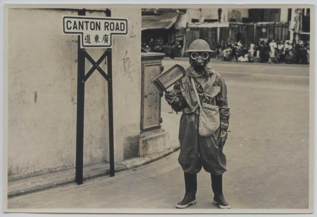
Greetings. I also think this was at the junction with Jordan Road. The road alignment here was most likely the same as that shown on the 1956 map -
https://gwulo.com/node/31747#17/22.30491/114.16812/Map_by_ESRI-1956_Kow…; . This would put Canton Road northbound meeting Jordon Road between Wai Ching Street and Canton Road. Behind the wall at this corner would then be the former Admiralty Property. I can't remember how Wai Ching Street looked like in 1950 when I walked there for my Primary 1 class (another one of my many schools). However the awnings on that corner shop suggests that it was facing south to keep the sun out. Regards, Peter
Update April 3, 2019 - The memory has come back, now 99% sure. The corner in the background is the start of Wai Ching Street. I walked by that shop's corner on my way to Wah Nam Primary School about 8 shops beyond that. I remember the awnings. It appears the street was blocked but in fact only one half was blocked by vendors selling vegetables and clothings. This is the only photo I have seen having a connection to my first school, thank you. Regards, Peter
Comments
Re: Photo
Given the wide road on the right, the view may be the junction of Canton and Jordan Roads.
The warden is holding a
The warden is holding a gas rattle, used to make a noise to alert people of a gas attack.
gas rattle, ARP © IWM (EPH 9543)
enquiry from Hong Kong Museum of History
Dear Philip,
I am writing from the Hong Kong Museum of History and would like to seek your kind assistance in providing me with the high resolution files of the gas precaution training in Hong Kong as you have uploaded. If there is someone else holding the images, can you please connect me with the right party so that I can approach them direct for the high-rsolution files and the usage rights. I can be reached anytime at my office email of oshchan@lcsd.gov.hk
I sincerely look forward to your reply. Many thanks.
Osmond
Canton and Jordan Road Junction
Greetings. I also think this was at the junction with Jordan Road. The road alignment here was most likely the same as that shown on the 1956 map -
https://gwulo.com/node/31747#17/22.30491/114.16812/Map_by_ESRI-1956_Kow…; . This would put Canton Road northbound meeting Jordon Road between Wai Ching Street and Canton Road. Behind the wall at this corner would then be the former Admiralty Property. I can't remember how Wai Ching Street looked like in 1950 when I walked there for my Primary 1 class (another one of my many schools). However the awnings on that corner shop suggests that it was facing south to keep the sun out. Regards, Peter
Update April 3, 2019 - The memory has come back, now 99% sure. The corner in the background is the start of Wai Ching Street. I walked by that shop's corner on my way to Wah Nam Primary School about 8 shops beyond that. I remember the awnings. It appears the street was blocked but in fact only one half was blocked by vendors selling vegetables and clothings. This is the only photo I have seen having a connection to my first school, thank you. Regards, Peter