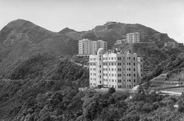
It looks like Lugard Road (corrected by Geoff to Harlech Road) contouring around the hillside on the left, with Mt Austin Road curving upwards in the centre? If so, from where did Peter take the photograph? (Andrew S). Geoff's other comments indicate that Peter must hve been standing somewhere on the Peak Road to the East of Peak Mansions. (Andrew S)
Date picture taken
1 Oct 1953
Gallery
Shows place(s)
Comments
Peak Mansions
Hi Andrew,
Yes, Mt Austin Road is curving upwards in the centre. The road contouring Mt Austin is called Harlech Road on the south side, Lugard Road on the north, so this is Harlech Road. Peak Mansions is the large building in the foreground with Mt Austin Mansions directly above. Given the angle, I think Peter would have been somewhere near Jardines Corner (junction of Peak Road and Mt Kellett Road).
Thanks for the clarification
Thanks for the clarification Geoff. As you pointed out, I always thought that the road running around the South side of the Peak was called Harlech Road - but on the map I saw that the first fairly long section of it is called Lugard Road. Confusing! Is that a typographical error? Regards, Andrew
Harlech or Lugard Road?
Hi Andrew,
Mmmhh, I see what you mean! In my minds eye there's a street sign saying "Harlech Road" opposite and facing the Peak Cafe, just below where Mt Austin Road starts its climb. Unfortunately a vehicle is blocking the sign on Google Streetview so I can't confirm either way, but the normal Google map has it as Harlech Road.
Ravencourt & Harlech Road
Hi Andrew,
I think the darkish block nearest the top right corner is Ravencourt under construction. According to the document at https://gwulo.com/media/14268 it was constructed between September 1953 and September 1954.
Regarding the Harlech or Lugard Road question above, here's a pic from Google Street View showing the street sign for Harlech Road.