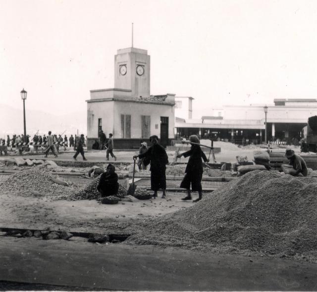
This looks like the junction of Peddar Street and Connaught Road. Was the former being widened? Why is there damage on the upper part of the Star Ferry building? What are the 'new' buildings in the background? I think that they are too early to be the new Star Ferry building or the multi storey car park. I suspect that the date is more likely 1953. Any thoughts? (Andrew S) Thanks to Thomas it is the Jordan road pier.
Date picture taken
1953
Gallery
Shows place(s)
Comments
Re: Probably not Star Ferry
Hi There,
I suspect it was Jordan Road Pier instead, before the expansion.
T
Thanks Thomas. I've looked
Thanks Thomas. I've looked at images of the Jordan Road pier and I agree. I'll change the title and add it to places on the map. Andrew
Location
Hi Andrew and Thomas,
to start, I don't have a better idea for the correct location. But what puzzles me is the shape of the clock tower which is longer compared to the one on the 1950' photo. Also, it looks like as if there was an isolated clock tower where on other photos from that time it was integrated into the building. And the street lamp is different to the ones on other photos. And if its Jordan Road, where would the photographer have been standing?
Regards, Klaus
Hi Klaus and Thomas,
Hi Klaus and Thomas,
That’s very interesting, Klaus. Comparing Ewart’s image with verified images of the Jordan Road terminal, I tend to agree. The towers are quite different. Is it possible that there was another, similar pier head that we have not thought of, and the range of hills just visible in the left background looks to me more like those on the mainland. If so, Ewart’s pier head would have been on the Island. A bit of a mystery! Andrew
Jordan Road Ferry Pier
Greetings. I think that horizontal beam on the right of the photo is part of the ramp-adjustment. This would give a good idea of the location of the camera. I seem to remember that the clock tower stood alone at one time, and it was the same one they placed on the roof supported by new concrete.. Regards, Peter
Jubilee Street - Vehicular Ferry Pier
The original photo is of the Jubilee Street Vehicular Ferry Pier (Hong Kong Island). The standalone clock tower can be viewed below:
Ferry Pier - which one is this?
Greetings. In my time living in Hong Kong, my use of ferry was limited to the Star, Jordan and Sham Shui Po. As discussions were pointing Andrew's photo towards the Jordan ferry, I tend to agree especially when I look at its stand alone clock tower - memory of it is coming back. The buses I took passed by it at their terminal, and without a canopy. The clock tower's orientation relative to the ramp-adjustment superstructure differs between the two photos. Andrew's clock tower appears not normal (90 degrees) to the to the superstructure, and it appears the truck on the right of the photo was in queue for the ferry. I am also looking at this night photo - https://gwulo.com/media/12597. They are, well, so similar, and they are playing tricks on me with their canopy and door openings. I think yours moddsey is the right match. Regards, Peter
1950s Vehicular Ferry Pier, Central
The standalone clock tower and lamp post can be seen below:
Re: Jubilee Street Pier
Hi There,
No wonder. This was before my time so I have never seen this clock. That was supposed to be where they collect the Toll for vehicles before further reclamation.......
So the top photo would be under construction in preparation of the expansion.
T
Hi everyone,
Hi everyone,
Thank you all for your thoughts on the location. Moddsey's contribution shows that it was the Jubilee Street pier. It is so similar in style and presumably age to the Jordan Road one that maybe I should have checked out the Island terminal. straight away. I'll change the title. I am now wondering from what buiding Ewart took his photgraph. Regards, Andrew
Re: photo location
Hi Andres,
That looks like a street photo. It was a construction site for the expension of the pier as the clock appeared to be in the progress of being taken down while workers are preparing the ground for something else. At that time, the formiddable Fire Department building block would be at the back.
T
Hi Thomas. Sorry, I was
Hi Thomas. Sorry, I was looking at one of the other photographs! I've only just woken up! Andrew
What pier is this?
The original clock tower photo, the 2 photos purportedly identified as the Jubilee Pier, and this photo identified as the Jordan Ferry Pier were all of the same pier. Note the identical black building with 3 white stripes on the roof in 3 of the 4 photos, and the building just peeking out from the right side of it in the colored photo is similar to the one in the original photo.
https://www.facebook.com/photo.php?fbid=2263101260672284&set=gm.10156089134986712&type=3&theater&ifg=1
and this Google map from the present day Jordan Road waterfront shows the mountain ranges in the background on the left side are the same as those in the colored photo of the Jordan Ferry Pier, those on the right side look similar to the ones in the Jubilee Pier photos.
https://www.google.com/maps/@22.3076606,114.160689,3a,30y,237.88h,89.4t/data=!3m7!1e1!3m5!1sfU7K8K6Jf8TqIuku9vzmHA!2e0!6s%2F%2Fgeo0.ggpht.com%2Fcbk%3Fpanoid%3DfU7K8K6Jf8TqIuku9vzmHA%26output%3Dthumbnail%26cb_client%3Dmaps_sv.tactile.gps%26thumb%3D2%26w%3D203%26h%3D100%26yaw%3D107.89647%26pitch%3D0%26thumbfov%3D100!7i13312!8i6656
Jubilee Pier
The photo on the facebook link is Jordan Road pier with the west end of HK Island in the background. Note that the Jordan Road pier clocktower is an integral part of the pier building. Conversely, the two images posted by Moddsey are of Jubilee with the view looking east towards the east end of HK Island with the low sloping ridgeline above North Point. Note that on both those images, there is no integrated clocktower, although at first glance the buildings appear to be similar.