Current condition
Demolished / No longer exists
Date completed
(Day, Month, & Year are approximate.)
Date closed / demolished
(Day, Month, & Year are approximate.)
The dates are guesses, based on the construction of the Kowloon-Canton railway line.
The location is also a guess. We know there was a ropeway built here to ferry workers from their camp to the Beacon Hill tunnel, but I'm not sure of the location of the camp or the route of the ropeway. Suggestions welcome!
Here are the couple of mentions I've found:
- A further 850m-long cableway was also built about 1907 to transport foremen and miners, at that time constructing the Kowloon-Canton Railway Beacon Hill tunnel, to bungalows on a hill the other side of the valley from the north portal (most probably at Sha Tin Heights).
'A LOOK BACK : CIVIL ENGINEERING IN HONG KONG 1841-1941', by C. Michael Guildford. - On a doctor's advice, all the Italians working on the Beacon Hill tunnel were housed high up on the hillsides and a ropeway was built to slide them gently down to work each day.
Page 481, 'Forgotten Souls', by Patricia Lim.
Regards, David
Photos that show this Place
1908
1900s
Comments
Beacon Hill
I'm assuming this is the NT side of Beacon Hill, right?
re: Beacon Hill
Yes, that's right.
I found a few more clues while reading through reports from that time:
"Among the contractors I would make special mention of Mr. Ghella. He came to Shatin early in 1907 and started in a small way, sinking the 270ft shaft [...]."
Hong KongWeekly Press, 24 May 1909, pg 11.
At first I thought they just tunnelled north and south from the two entrances, which would have them working on two rock faces at the same time.
But they also sank vertical shafts along the route of the tunnel: a 90-foot shaft near the southern entrance, and a 270-foot shaft some distance from the northern entrance. Then from the bottom of each vertical shaft they'd also start tunnelling north & south, so at different times there were six different faces being worked on.
The benefits of that were explained in the 1908 annual report:
During 1908 another 3,544 feet was driven making a total of 5,644 feet altogether, of which 2,528 was driven from the South and 3,116 from the North Side. The difference in distance was due to a large extent to the length of 500 feet driven both ways from the shaft at the North Side.
Mr. Ghella was in charge of the Italian miners. I think the ropeway likely ran between the camp and the entrance to the 270-foot vertical shaft mentioned above - though it may well have run to other sites as well. So far I haven't found any mention of avoiding malaria as a reason for the ropeway.
The original Beacon Hill Tunnel was only a single-track tunnel, and was later replaced by a new double-track tunnel. If you zoom in on http://www1.map.gov.hk/gih3/view/index.jsp, the disused original tunnel is shown.
I wondered if there are any visible signs of that vertical shaft. The 1909 annual report suggests not:
"There does not seem to be any use in perpetuating the shaft on the North Face which is too near the portal to be of any service as a ventilating shaft, and as it would have cost a great deal more to brick it up than the estimated cost of six thousand dollars, owing to the very wet nature of the ground, the shaft will be filled in and suitable arrangements made to cope with the water which comes down it."
And I don't see any sign of it on the government map. Still I guess it would look somehow different from the surrounding land if we knew what we were looking for.
Regards, David
Old tunnel
Try as I might I can't see the old tunnel marked on the geomap, only the current one. But there is a nice picture on GoogleEarth of the old entrance which makes it look as though the old tunnel runs to the east and parallel to the current one.
http://www.panoramio.com/photo/6814650
Keng Hau - Beacon Hill Tunnel - temp. KCR staff quarters
The two words you can't read will be Keng Hau.
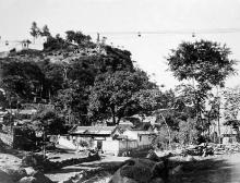
This is up on the hillside above the Sha Tin Beacon Hill tunnel portal, where the temporary European staff quarters were built in an attempt to escape the malarial mosquitoes. The aerial ropeway ran from the valley up to the quarters.
Keng Hau Road still exists and the properties now on this very steep incline were probably built on the site of the old staff quarters. I remember in the 60’s there were still some very old stone buildings on this road.
There is photo of the tunnel and railway construction site in this 1909 magazine. (http://i1103.photobucket.com/albums/g468/chinarail1/Beacon-Hill-Tunnel-ShaTin-FER-Nov1909.jpg) . That tall wooden framed tower ( top right of picture) is possibly the structure supporting the ropeway.
Does anyone know if that scar along the hillside at the top of the picture could be Taipo road?
regards,
Chinarail
(P.A. Crush)
Old tunnel / Ropeway
Phil, The trick is to click the "detailed map" button, and zoom right in. The site of the entrance is also visible on the satellite view, shown here.
Peter, thanks very much for the 1909 photo, that's a big help.
I think the scar along the hillside is from digging the catchwater for the Kowloon Reservoir. That reservoir was completed in 1910, so it would have been fresh then, and the line matches up with the catchwater on later maps.
Looking at your photo, I can see several buildings up the hillside between the portal and the scar. I guess they were temporary European staff quarters. Does that sound right, or do you know if any were built higher up?
You wrote "The aerial ropeway ran from the valley up to the quarters." I think it more likely that the ropeway carried the workers up to the 270ft shaft, but I'm not sure.
I did find a mention that the shaft continued in use after the miners at its base met up with those tunneling south from the north portal:
"It seemed to Mr. Waring that the sinking of a shaft 250 feet deep - most of it, he supposed, through granite - must have occupied a long time, and perhaps the time occupied and the cost of this shaft ($88,000) had been hardly warranted merely in order to obtain two additional working-faces in the heading. Had the shaft been retained for the purpose of ventilation, the case would have been different; but the Author stated that the shafts were plugged after the completion of the tunnel."
[Mr Eves replied] "The advisability of sinking deep shafts was often questioned. [...] As 500 feet of heading was driven from the bottom of the shaft alone, about 100 days were gained directly. Besides which all the material excavated in driving the heading at the north side was brought up the shaft, which relieved the congestion of traffic throughthe portal."
From pages 207 and 232 of Eves GW (1911) The Canton- Kowloon Railway: British section. Minutes of the Proc. of the Institution of Civil Engineers. vol 192 pp 190-204. (Discussion, vol 192, pp 205 -246)
Would they have used the ropeway to carry the excavated material down to ground level where it could be used elsewhere in the construction?
I'll guess the ropeway ran to the left of the four black buildings. At 11 o'clock from them there's a small embankment that looks about right for a pylon. But again, just a guess!
Regards, David
More about the ropeway
With Bob & IDJ's help I've been reading this 1911 article from The Engineer (see pages 428-430, and the photos on page 431).
It gives more facts & figures:
If the North shaft opening is 366ft (98+268), or 112m above sea level, and 1290ft / 392m south of the portal, it was a little way in front of the catchwater shown in Peter's photo. (The catchwater runs along the 145m contour). That puts paid to my ropeway-to-shaft idea!
So instead we're looking for it to run from around the portal to the bungalows, somewhere appx 2800ft / 851 m away, and around the 498ft / 151m contour.
Regards, David
Re: Beacon Hill Tunnel
North Portal (HKPL Archive)
South Portal (?)
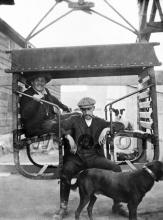
Beacon Hill Tunnel Work Party
Received as is. (North or South)
Ropeway / Shatin Heights
Moddsey, thanks for the extra photos.
Thanks also to Peter, who sent the relevant section from the Institute of Civil Engineers article:
Owing to the numerous casualties due to malaria a commission of local doctors advised that all the Europeans working at the north face should live on the top of the hills on the other side of the valley from the tunnel portal. This would have entailed going down the Beacon Hill into the valley and climbing up a height of 430 feet on the other side. In order to avoid the delay, a passenger-ropeway was erected to carry the foremen and miners across the valley and up to the top of the opposite hill. Its length was 2,800 feet, and the difference of levels of the terminals was 280 feet. The cost of running this ropeway was $270 per month.
So rather than running up the slope above the portal, instead it ran north across the valley and up the opposite slope. Peter also noted "At 2,800 ft long it might have been too long to have only finished at the top of today's Keng Hau Rd/Taipo Road junction. It might have actually gone to the top of Sha Tin Heights ( the site of today's Ascot and Golden Time Villas). "
If I use the measuring tool on the Government's Map Website, and draw a line 851m from the portal, it brings me to the 150m contour just in front of Ascot Villa! So somewhere around there seems likely for the location of the Europeans' bungalows, and end of the ropeway.
Sha Tin Heights was where Phil & Thomas had suggested earlier. Sorry for being dense, I thought that area was further south, but now see it's the area around Ascot Villa / Golden Time Villas that Peter described.
That's a good-enough answer for now, but hopefully a sharper photo will turn up at some point to confirm it.
Thanks again for everyone's help,
Regards, David
Re: Original Beacon Hill Tunnel
Maps showing the location of the original Beacon Hill Tunnel and the portals are available:
https://docs.google.com/viewer?a=v&q=cache:0Ke5UOQk5WoJ:www.epd.gov.hk/…
Beacon Hill Tunnel construction
Just noticed this photo in the Swire collection:
http://hpc.vcea.net/Collection/Warren_Swire_Images?ID=20277
It's a sharp photo, but unfortunately there's no sign of the ropeway.
Regards, David
Potential foundation for aerial ropeway?
These concrete blocks have always intrigued me from a very young age whenever I visited the graves of my great-grannies where the blocks lie on a flat ground immediately behind the graves. The urge to rediscover them has only been triggered recently after I came across information of a local tour which takes visitors to the hills above Quarry Bay to look at the remnants of the built heritage left behind by Swire. One of the photo from the tour really intrigues me as it shows cable car foundations which would look remarkably similar to the ones behind the graves of my ancestors.
From my observation, there appears to be a rectangular grid of 5x3, together with two particularly chunky blocks sitting in the centre of the grid which have been engulfed by some banyan trees. And there appears to be some exposed metallic remnants sitting in the centre of each of the blocks.
The blocks could be found in the Woodcrest Hill housing estate at the end of a flight of stairs on top of a small hill and I have included a map here as well.