In the 1945 photo of HKU posted recently, an 8-sided roof down in the foreground caught my eye:

It's the roof of a cast-iron water tank. The tank is right at the top of the campus, near the entrance to the university from Kotewall Road.
I've seen it many times over the years, and wondered how old it is. Now we know it dates back to 1945 at least.
Here are some photos I took this morning. If you walk along the path above University Avenue, when you get near the top you'll see the tank off in a clump of trees to the left:


One of the panels has the text "B O" and a symbol on:


The roof has rusted through. Poking a camera inside shows the old roof supports still in place, but that several of the roof segments have collapsed:

Can anyone tell us when it was built, and what the characters and symbol mean?
Photos that show this Place
Comments
Re: Letters and Symbol
The "Broad Arrow" and letters B O refer to Board of Ordnance or simply Government Property. I think the cast iron tank had something to do with the Victoria Battery which does make it quite a relic from the past.
Re: Letters and Symbol
Moddsey, thanks for the pointers. Looking up the history of the Board of Ordnance, Wikipedia says the Board was dissolved in 1855. I'm not sure if the "B /|\ O" continued to be used after that? If not then the tank is over 160 years old!
One oddity is the curved sides of the arrow on the tank. The images I've seen of the broad arrow all show it with straight sides, eg https://www.google.com.hk/search?q=board+of+ordnance+broad+arrow&espv=2…
I'm not sure if this arrow's curves have any significance. More research required.
Regards, David
Curved arrow
I asked about the curved broad arrow on the "British & Commonwealth Military Badge Forum", and was shown a couple of other examples: http://www.britishbadgeforum.com/forums/showthread.php?p=392742&posted=1
The Board of Ordnance was dissolved in May 1855, so I assume the "B /|\ O" mark went out of use at about that time?
In that case the tank dates back to the early history of the British in Hong Kong. Next job is to find out when it was installed at this location. Was it put here originally, or moved here later from another location?
When was it built?
My first thought was that it couldn't have been built here before 1855, as there wasn't any development out this far away from Central. But looking at the 1845 map (http://gwulo.com/node/36439#15/22.2838/114.1396/Map_by_ESRI-1845_HK-Mar…), the West Point Barracks were downhill from the site of the tank. That's no evidence that the tank was already in place then, but it does show the British Military were building in this area as far back as 1845.
And a small coincidence - looking at the map linked to above, to the right and slightly below the yellow marker there's an upside-down Board of Ordnance stamp, B/|\O, showing who made the map.
Cast Iron Water Tanks
Further reading here on iron water tanks for the Bahamas.
re: Cast Iron Water Tanks
Thanks Moddsey, that's a good find. I can imagine similar requests being made from Hong Kong at the time.
re: Cast Iron Water Tanks
I mentioned this tank to Stephen Davies, as he'd recently found another Board of Ordnance mark out at Sai Wan. Stephen noted that the British Military rarely made one-off items for something as common as a water tank, so if this is a military water tank there should be others out there just like it. And that's what he's found:
I think I have found the [HKU] tank’s twins. They’re in South Africa where there are apparently several and they are there also associated with the military: http://bwtas.blogspot.hk/2009/05/simons-town-mystery-tanks.html. The description is bang on, though the one pictured seems to have been two-layered as opposed to the HKU singleton. Interestingly the South African examples appear to have no casting/foundry marks at all.
The person who reported those South African tanks was named David Erickson. Stephen's email to David bounced, so he followed another lead to Richard Baker, who'd also been in contact with David Erickson about these water tanks. Richard remembered the discussion, and wrote:
It was certainly clear that these tanks were everywhere with the British military.
So it does seem very likely that the tank at HKU was originally built for the British Military, and the BO mark dates it to having been made in 1855 or earlier.
Next, what can we find out about its history in Hong Kong? We know it's been on this site since at least 1945. How far back can we trace it at its current location?
I turned to Rob Weir, asking if he had any details of the site, and he kindly sent over the site plan from 1890 (UK National Archive ref: WO 78/5363).
The modern map of the area clearly shows the tank. I've marked it with a red x:
Then I've overlaid the 1890 site plan over the modern map, so we can see roughly where the tank was:
So it seems very unlikely that the tank was here in 1890:
Moving forward in time, is it shown in the 1924 aerial survey photos? I visited the SMO to look at the photos on their map kiosks. I can't see any sign of the tank. The photos aren't exceptionally clear, so I may be mistaken but I don't think so. I've ordered prints of the photos, and will take a closer look when they arrive in about a week.
So what are the possibilities? Stephen suggests:
- that the tank may originally have been either elsewhere in HK - in use or in store - and relocated to HKU later. For example some sort of a WW2 ARP preparation. Was there any sort of a static tank creation programme to assist in fire fighting in the run up to 1941?
- that ditto, but the relocation was done by the Japanese
Stephen has also contacted the University's Estates Office and Archives to see if they have any record of the tank being installed pre-WW2.
Any other information about the tank's history gratefully received!
David the tank appears on a
David a hexagonal tank appears on a mid 1920's street map in a different location in front of the filter beds
Could it be something to do with the water distribution system from the filter beds and it was moved to its current location when it wasn't needed anymore?
There is also a hexagonal water tank just above Hospital road at the top of Pound lane on the 1901 city map and others. A photo of it is here just above and to the right of the tree. Possibly the same/a similar tank
The 1889 Map of Victoria Battery does have a hexagonal shape in the middle very close to where the tank is today:
Looking at the 2 1913 maps on hkmaps.hk site the hexagonal shape appears in two separate locations. One location is in front of the filter beds, the other is within the Victoria Battery
New maps and photos
Good to see more maps of the area.
Unfortunately the 1924 map doesn't label what the hexagon shape is, but a water tank is a likely candidate. I don't think it's the same tank though, because it was 6- vs 8-sided.
The shape over in the Victoria Battery in the 1889 and 1913 maps is less clear. It looks more round than angular. I'm not sure if it has any connection to water tanks, or just shows the location of the old emplacement.
Good point about the tank over above Hospital Road. There were definitely several large cast iron water tanks around Hong Kong in the 19th century.
Those South African tanks
I went back with a tape measure today to measure a side panel. It was 212cm wide and 80cm high.
I was hoping that it would be the same size as the panels on the tanks in Simons Town, South African, confirming they were made to the same pattern. Unfortunately those panels measure 158cm wide x 103.5cm high, so no match there.
I've just written to the
I've just written to the Museum of Coastal Defence to see if they know of any similar tanks around Hong Kong.
8-sided tank on Bonham Road
This map from 1889 shows an eight-sided shape marked "Hospital Tank" (A on the map - zoom in for a closer view):
It's not clear what, if any connection there is with the tank at HKU, but it is of a similar scale.
Near to the Hospital Tank there was another small tank, "Cleverly Tank" (B), and a larger "No. 1 Tank" (C). The No.1 Tank is fed from the conduit (D). It's not clear whether the Hospital and Cleverly Tanks were linked to them, or pre-dated the conduit and were fed from the small stream visible near B.
The Hospital Tank was likely for the "Chinese Hospital", ie the Tung Wah Hospital at E, rather than the more distant Civil Hospital at F.
Octagonal tanks
Excellent find David - that must have required some searching. What it reveals, independently of whether this is the HKU tank, is that such tanks were in use in HK by 1889 and probably before this, since the siting of the tank looks slightly odd - as if the road was not in the mapped alignment when the tank was erected.
It will be interesting to track backwards and forwards if possible and see when the tank appeared and disappeared.
The best I can instantly do is note that it is still in place, only between Bonham and Hospital Roads, just to the east of Ripon Terrace, on the 1901 street map at www.hkmaps.hk
Best,
Stephen
1913
Hi Stephen and David,
On the 1913 map (http://www.hkmaps.hk/map_1913.html) that circular looking tank was still there.
On the same map in Victoria Barracks, there is a suspicious spot too. Could that be the tank?
breskvar
Tanks
Stephen, I have to admit it was luck to find that view of the Hospital Tank. I was looking at the 1889 map for another project, and happened to see it. Here's another map from 1901 that shows the octagon shape very clearly:
Breskvar, thanks for tracking the Hospital Tank forward to 1913. As it was around for many years, hopefully there's a photo out there somewhere that gives us a clear view of it.
About the circle in the Victoria Battery site, it could be a water tank, though I haven't seen a label for it yet to confirm what it was. It's further east than the tank we're looking at, as the 1913 map shows the circle north of the top corner of IL 1874. That lot still exists and can be seen on the Geoinfo Map (screenshot below), putting the circle somewhere in the grounds of the University Lodge. (You can see the tank we're interested in to the left/west, across on the other side of University Drive.)
Re: Tank between Hospital & Bonham Roads
Hi David,
I believe the location is a garden for quite a while. At least a bit more than two decades. I wonder if the bricks and rocks as seen in Street View would have anything to do with the Tank.
T
The pictures that we have of
The pictures that we have of the Hospital Road tank here suggest that is was made of stone rather than iron.
In the early part of the 20th Century there was a move to steam pumping of water from a gravity based distribution system that required large tanks (like Tank 1 and Tank 2) Around the start of WW1 both large tanks were being redeveloped so it is probably that the Hospital Road tank was demolished around this time as it was no longer required
This picture shows the hexagonal shape in front of the filter beds was something separate - probably a pumping station
On the 1889 map there are further hexagonal/octagonal tank shaped objects at the end of the Conduit road syphon just uphill of Canossa Hospital and two others north of Canossa above Glenealy Tank. There is also one in the botanical gardens just below the Albany (separate form the bandstand) and another between the two Murray Barrack blocks next to the cook/wash houses.
I see what you mean about the
I see what you mean about the Hospital Tank - it does look to have been built from stone, so not a close relative of the tank above HKU.
1923 Survey of Western District
Additonal map. In 1920, Victoria Battery was transferred to the Government.
Aerial photos
The three aerial photos taken in 1924 that I ordered arrived last week. The SMO references for the photos are H19.8, H25.18, and HQ6.27.
H25.18 has the best view of the area we're interested it. Here it is aligned with north at the top, and a purple dot approximately where the octagonal iron tank is today:
So no sign of any tank here in 1924, but there was something over on the Victoria Battery site.
Next I thank Kevin Styles for contacting me and offering to give me some tips on interpreting aerial photos, something he does a lot in his work as a geologist. Here's Kevin earlier today with his secret weapon, a stereoscope:
It allows us to view two aerial photos taken from different angles, so that the brain interprets them in 3D. We looked at a pair of photos taken in 1963, and as expected, the octagonal tank is clear to see.
A pair of 1924 photos confirm that at that time there was no tank where it stands today. However they do show a raised structure over on the site of the old Victoria Battery. Unfortunately the photos are not clear enough to tell us its shape or function.
There weren't any aerial surveys made between 1924, and 1945 when the photo shown above was taken. So to see what happened between 1924-1945 we'll need other sources, eg: non-survey photos taken from aircraft; photos of the university campus taken from the ground (views from around Morrison Hall or up at the the Peak would be useful); maps; other documents.
There was supposedly an
There was supposedly an aerial survey carried out in the 1930's by the fleet air arm but I have not seen any systemic aerial mapping of HK from it.
Are there any more photos from the Elizabeth Ride collection that would show the area. This one is very close to the area we have been looking at
Aerial surveys
I haven't heard about a 1930s aerial survey before. That would be ideal! Can you remember where you heard about it?
I've written to Elizabeth to ask if there were other aerial photos in that collection.
David, see my comment here for
David, see my comment here for details of aerial photography of HK in the 1930s. It was carried out by the air wings of HMS Hermes and HMS Pegasus.
I also found this map of HKU from the 1930s. It shows the iron water tank in its current location:
The water tank
Thanks Herostratus - the hexagon rather than octagon is very likely a cartographer's fudge - but with some rubber sheeting, it's clear it is shown so close to the present location that the probabilty of this being the same object is high. It is extremely helpful to have the 1933 date, since that immediately zaps the hitherto plausible hypotheses about ARP static tanks, occupation period emergency water supplies and immediate post-war emergency supplies. That said, it also then deepens the puzzle since, with the return of the Victoria Battery site to the government in 1920 and the absence of any sign of the tank in the 1924 aerial photos, whilst we have very much narrowed the window (now 1924-1933), who put it there and why becomes a harder nut to crack (war is always such a helpful answer!)
Here at HKU we are now buckling down to solving the problems and signs are very encouraging that the University has confirmed it is University property and seems to be intending to take seriously its responsibilities for so curious and probably ancient a relic. We have already learned from an interview with one of the retired Estates Office gardeners that it was still being used for water for the Estates' nursery (between May Hall and the Vice-Chancellor's Lodge) in the late 1970s-early 1980s, which explains the blue plastic ballcock that has fallen down into the interior and of which some old pipework may remain. We also know that the tank is unquestionably cast iron, not pressed steel (late 19th century RE types) and the caulking/jointing compound is red lead (Pb3O4) - consistent with Royal Engineers' practice. There is some plausible but ambiguous evidence on the ground that the tank may have been gravity fed from the small dam in the stream bed to the west of the Kotewall Rd Fire Station.
So far the little evidence we have suggests that the tank was NOT on HKU premises until well post-war, but this is now being checked in the old files to see when the main campus land lot areas were extended far enough south to snaffle the tract with the tank and whether any of the relevant documentation mentions the tank. If this is the case, then clearly HKU will have played no part in the placing of the tank and another explanatory avenue will have closed.
On a wider note, thanks to Richard Barker in the UK and David Erickson in South Africa, we now know of similar tanks in South Africa (Lions Battery Cape Town & Arsenal Rd Simon's Town, both c.mid-19th century); St Helena (1901 - the three, at Half Tree Hollow, are very similar to the HKU example, but the casting mark identifies the known late 19th century makers, Douglass Bros Ltd of Bladon-on-Tyne); Lenan Head, Lough Swilly, Ireland (1901 (?) and possibly hexagonal, also Douglass Bros Ltd); Harwich Redoubt Fort (pre-1850? - no casting marks); and Ascension Island (top of Breakneck Valley and installed by the RE in the 1830s - no other detail).
I am in touch with Ascension and St Helena, the former seeming the most promising possiblity for a Board of Ordnance provenance.
If HKU confirms its backing for the conservation, there will be more news. As with all such difficult and ramified decision making, that will be unlikely to come swiftly.
Stephen D
Date Range
Looking at the narrowing of the date window (1924-1933), there is a possibility that the installation of the tank may have been related to the water crisis in 1929.
yes, yes
Brilliant Moddsey, thanks so much because I think you may have hit the spot, if not exactly with the 1929 event then related thereto.
Govt Notice 5/1930, Water Shortage Emergency June-August 1929 has some details. A critical detail in Appendix B notes that the government response was to acquire tanks through the Crown Agents (and by implication other sources) and that by mid-1929 a total of some 26 tanks had been erected around the territory. Encouraging though that is, Appendix G only mentions steel, cement and concrete, and brick tanks. More to the point, in the 1929 PWD Report the only sites for the emergency tanks would appear to have been on or close to the waterfront where they could be readily replenished by the hired in flotilla of water tankers.
However, in both documents vital maps are missing (in almost all government documents in the HKU online system, wherever a plan or map is mentioned it has NOT been included in the document for some reason that makes sense to an IT maven) so we can't see where the tanks were placed. From the general narratives the only hint of tanks above c.100' above MSL is a sentence in one of the meeting summaries in the first, emergency report, that notes "Should there be a further continuance of the drought the position by October might be as follows: All houses as far as Caine Road level may then have to depend entirely on tank supplies."
The only other possible 'hit' your excellent suggestion has come up with, in the PWD Report for 1931 (though the topographical designators and the shortcomings of my knowledge don't combine to give pinpoint precision), is the statement, "Two steel plate tanks having a combined capacity of 60,000 gallonswere erected near the West Point filter beds to act as balance tanks to the Robinson Road zone." (The capacity of the HKU tank is around 30,000 gallons.) There seems to be some doubt as to whether the West Point filter beds are all same as the Elliot Filter beds. If they are the same (the balance of opinion seems to think they are), then the problem becomes how near is near?
Anyway, water supplies issues in the 1924-1933 period seem to be a fruitful area to research. Thanks much.
Stephen D
Stephen, the map came from
Stephen, the map came from the HKU estates office here, have you asked them to see if they have any others showing this area?
The 1924 aerial photos are not really clear enough to be sure there is no water tank at this location
Elliot and West point filter beds are in different locations. The West point filter beds are where todays Kotewell Road service reservoirs are. The Elliot Filter beds were where todays Elliot Treatment Works building is, behind HKU's Cheng Yu Tung Tower.
the water tank
Thanks Herostratus - a wonderful case of left hand and right hand. We had two Estates Office senior personnel at a recent meeting. Neither seemed to know either of this map or, indeed of this web page (no more did I or the University Archivist!). Maybe too much information is almost as big a problem as too little!
The web page resolution isn't good enough to zero in on what is written beside the tank. Once I find out where the original is so it can be read, I'll come back and reveal all.
Stephen D
Water tank
I'm in the UK for a couple of weeks, so a bit slow on the follow-up. Good to see the range of possible installation dates has been narrowed, and the c.1930 water shortage reason sounds very likely.
One bit of feedback on "Elliot and West point filter beds are in different locations." I think it's the "West Point Filter Beds" name that has moved over the years. The 1889 map shows that name used for the filter beds up at the top of HKU, but maps from the 20th century show those beds called the "Pokfulam Fiter Beds", and the West Point name used on the newer beds down on today's Centennial Campus site. So around the time of the 1931 water shortage reports, they'd mean those newer beds when they say "West Point filter beds".
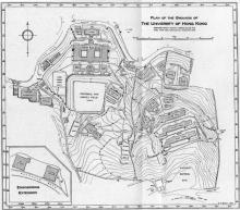
I spent the day at the National Archives yesterday, and found a couple of relevant documents. A detailed plan of the area from 1910, "Plan of the proposed site for a University on Bonham Road and Pokfulam Road." confirms no sign of the tank at that time:
And a search for Hong Kong water tank surprisingly turned up something useful, an 1850 map referring to cast iron water tanks on military land:
Reference: MFQ 1/962/7
Description: Hong Kong. Plan of part of the cantonment at Victoria showing the position of cast iron water pipes and tanks with stop-cocks and fire plugs, and the sites of a proposed new tank and the first proposed masonry tank and pipes. The relative positions of the proposed additional stop-cocks and fire plugs are also shown. Reference table. Scale: 1 inch to 2 chains. Compass indicator. Signed by John J Wilson, Royal Engineers. Originally accompanying a report by Lieutenant S A St John, Royal Engineers, itself enclosed in a report on the water supply to the Murray Barracks.
Date: 1850
The key says "Present cast iron Tanks and Water Pipes . . . . coloured blue". They're in the bottom left corner. Here's a close-up, showing they are octagonal as well:
the tanks
David - absolutely wonderful. Thank you so much. We now know for sure that cast iron water tanks, octagonal in shape (and perhaps sectional as per standard RE inventory) were in HK in 1850 and thus before 1855 so, if of the sectional variety (which seems pretty probable), likely with a BO mark.
From Collinson's detailed plans of the Saiwan and Stanley Cantonments, there do not appear to have been octagonal cast iron tanks in use in either other barracks location. Stanley has two wells marked (one of which I think may still exist and be in use opposite the Eight Houses) and, from the marking of 'bath' in the streambed below the barracks, Saiwan relied on a nearby stream (though no dam or conduits are shown).
The extra interest in what you have found is of course that the plan was prepared when the water supply system was being upgraded and, from the rubric, the cast iron tanks were being replaced by a masonry permanent tanks and that the plan for this was drawn up in October 1850 (one day after Trafalgar Day!). It would be interesting to know when the tanks moved - see the 1896 plan mentioned below. The military was (when I was with them) very belt and braces minded, so if there was no good reason to move the cast iron tanks elsewhere or strike them down to stores, it may be that they stayed in place until 1896...it would be amazing to discover that indeed they had.
Obviously there is no direct connection that links these four tanks to the one at present at HKU, but at least we now know there were four of what appear to be the right sort of tank in HK before 1850 serving Murray Barracks, which argues that they would have been sent out from Britain either with the First Opium War expeditionary force or, probably, rather later once the intention of garrisoning Hong Kong had gone firm - say during Pottinger's governorship 1843-1844.
The 1845 Cleverly map has no indications of water tanks and so forth where this plan shows them. One wonders whether the missing (well, not one I've seen found so far) large scale plan of Central from Collinson's 1844/45 topographical survey would have shown the tanks. Collinson's four sheet map of HK doesn't show any tanks in the Murray Barracks area, but the scale probably precluded them.
I notice that MFQ1/962/7 and MFQ1/962/8 are other maps of the same existing tankage and proposed new system. There appears once to have been a report that went with the plans, but I can't find a trace of it working online and from the catalogue entry, it seems probably to have gone the way of all flesh (and documents). I do note that WO78/3533 has a plan of the drainage and water supply of Murray Barracks in 1896 - if no sign of the octagonal tanks at that point, then again the record of their existence somewhere gets broken.
Again, great work and thanks so much.
Best,
Stephen
Tanks & filter beds
I copied all of MFQ 1/962 just in case. MFQ1/962/8 is a section through the site, but doesn't add much information. I'll have a look through other UKNA maps I'd copied when back to HK, to see if there are any other signs of the four tanks after 1850. They were high up the hill, well above Albany Barracks, so unfortunately they'd be off the edge of most of the early maps.
Also my earlier comment about the West Point Filter Beds name moving to the Elliot site isn't correct, as Herostratus has found examples where the name was still used for the upper filter beds in the 1930s and 40s:
https://gwulo.com/comment/39911#comment-39911
Regards, David
Murray Barracks water supply
In Moddsey's excellent photo at https://gwulo.com/atom/12352/zoom it seems to me that what we have in the foreground may be the second (i.e., the yellow coloured) masonry tank (or some development thereof - perhaps a pumping house?) that is marked on Lt Wilson's plan. I think I can see (!) a large iron pipe coming out of the wall on the front and plunging off down hill at a steep angle. Am I seeing things?
If what I am seeing is correct, then that gives us another bead on the position of the cast-iron tanks that David places somewhere up near what became The Albany. I'll see if I can get Ken Ching to georeference the 1850 plan so that where the tanks were can be exactly known.
StephenD
bally tanks again
Actually looking more closely at Moddsey's image in the version on the HKMMIS website, I am wondering whether the strange looking structure with the Fiji roof (a sort of mini roof on top of a roof) might have anything to do with the iron water tanks. Does anyone know what that structure was?
StephenD
The white building in the
The white building in the foreground is a telegraph station called the 'White House' or 'White Fort' in one of Floyds or Thomson's photos from around 1870. There is a place for it here
I believe the location of the four cast iron water tanks in the 1850 map is where the Albany filter beds were built.
The structure with the mini roof on top is a matshed used to protect construction that is progressing underneath. They are quite common in early photos.
enlightenment
Thanks much. Now enlightened - it's a very solid matshed. Any idea what they were building?
S
More maps & plans
I've been looking through the photos I took at the UKNA, and found a few more that are connected with this story.
First is the cross-section through the cast-iron pipeline, with the four iron tanks in blue at far right:
Zooming in on the tanks shows they were built in a pit, and gives an idea of what sort of structure we can keep a lookout for.
Another set of documents (UKNA ref: WO 55/2962) has this Plan of the Cantonment drawn in 1853:
The four tanks mentioned above are shown, so they were still around in 1853. They are marked as item 47, and the key reads:
47. Ditto for supplying the Barracks and Colonial Offices
It looks as though the masonry tank wasn't built, and the iron tanks continued in use. Then what about the "Ditto"?
Item 46 is listed as:
46. Water Tanks for supplying the Hospital
Item 46 is at lower right, just uphill from the point where two streams meet. It's another group of four tanks that looks to be the same design as item 47. It's good to see more examples, suggesting they were a standard item at that time.
The location of item 46 today is on the patch of land north of and downhill from the HK Electric Centre, between Kennedy Road and the bridge across the nullah into the old magazine.
The Hospital mentioned is marked on the map as:
41. Native Hospital
It stood on the hill where Paget House stands today.
water tanks
That's excellent data - we now know of probably eight octagonal, cast-iron sectional tanks that at some stage were extant in HK, all of them pre-1855, so all during the lifetime of the Board of Ordnance.
As David B has pointed out, the westernmost set of four appears to have been located up near what became the Albany filter beds and reservoir as of 1888. There is documentary evidence in Reports on the Water Supplies suggesting that the tanks remained in situ, but may have passed from Army to civilian hands at some unknown date 1850-1860s, whenupon they became known as the Albany Tanks - though of course the Anglo-Indian 'tank' (Gujerati by origin) was used for any artificially constructed water reservoir from a well to a huge cistern. The Albany Tanks are referred to in the 1859, 1875 and (retrospectively) the 1896 reports, and in an 1887 report by the Fire Brigade, whence it drew its firefighting water. With the construction of the new filter beds and reservoir (eventual outcomes of the 1873-75 plan for improving water supplies that resulted in the construction of Pokfulam Reservoir, the Conduit Path conduit and the West Point (later Pokfulam) Filter Beds), the Albany Tanks cease being mentioned.
The Estates Office at HKU has identified a document in their files that seems to indicate that the tank arrived on HKU campus as a result of the extension southwards of the southern campus boundary in c.1978. What has been found is a government plan to this effect dated 10-4-1978.
My colleague Lawrence Lai has recently found a lot plan of the south eastern part of campus (May Eliot and Lugard Halls), dating from 1926 which does NOT show the tank in the area it now stands. Whilst this is not definitive, the plan DOES show a hexagonal tank (also on the 1978 plan) that stood midway along the filter beds on their north (HKU campus) side, seemingly associated with the nullah that spills down today between the Knowles and KK Leung Buildings, possibly as an overflow.
It follows that the ‘window’ within which the HKU tank SEEMS to have arrived in its present position has narrowed to 1926-1933.
News from HKU is that there appears to be interest in the hierarchy in acting to conserve the tank and a fairly clear commitment to fully documenting it...but the mills of bureaucracy everywhere grind slow.
Stephen D
Hexagon & Octagon
I saw a 1959 map yesterday that had legends to explain the difference between these two. Our friend the octagon was marked "Tank" as expected. The hexagon, mid-way along the north side of the filter beds, was marked "Valve house".
The map is the 1:600 map, viewable on the Lands Department's Map kiosks. Their reference is sheet 195-SE-11.
Michael Wright
I've just written a letter to Michael Wright, asking if he remembers anything about this tank or any other similar tanks in Hong Kong. He returned to Hong Kong in 1938 to join the PWD, so there's a slim chance that he may have encountered it in his work. If I receive a reply I'll post it here.
iron water tank at HKU
Thanks David - and for the tip about the 1959 large scale map. Here at HKU things have gone quiet, no doubt as the wheels slowly turn. I'm waiting on some feedback from Ascension, which may have a contemporary tank - as far as I can work out, perhaps the only one also still in existence. I'll give my correspondent a gentle prod when the present press of business has eased.
Stephen D
re: Michael Wright
Michael wrote back, replying to my question:
I regret that I can give you no help w/ regard to the water tank.
Have you thought about for fire-fighting during the Japanese attack on Hong Kong?
Unfortunately Michael doesn't have internet access to see that the tank was already in place by 1934, and so was built before any wartime preparations. I'll write back to let him know.
Octagonal water tank at the Peak?
Moddsey has found a photo of a what looks like the same type of tank, up at the Peak in the late 19th Century. It is in the lower-right corner of the photo, and is three panels high like the one at HKU:
Relocation of the tanks
One niggle about how old the tank might be has been whether or not the tanks were moved about and re-used at different sites. If they were, then the HKU tank could be one of the tanks installed in Hong Kong in the early years of the colony, moved here at a later date. If it wasn't possible to relocate them, it would be very unlikely the tank arrived pre-1855, then sat in storage for several decades til it was installed above HKU.
We've found an example of cast iron water tanks being relocated from the Gleanealy Valley to the Peak in the early 1890s (https://gwulo.com/comment/41880#comment-41880), so the HKU tank may well be one of the old tanks that was relocated one or more times.
Capacity of HKU tank
I measured a panel as 2.12m wide and 0.8cm high.
The formula for the area of an octagon is 2*a*a*(1+sqrt{2}) = 2 * 2.12 * 2.12 * (1 + 1.414) = 21.7 sq.m
The tank is three panels high, so the maximum volume is 3 * 0.8 * 21.7 = 52 cubic.m
The conversion table says that is equivalent to 11,438 UK gallons. Allowing for the fact that the tank isn't filled to the top, I believe the HKU tank is a 10,000-gallon tank.
iron tank
Thanks David - I think from the BO casting mark there can be little doubt about its age even allowing for some sort of lag with a foundry updating its moulds - say almost certainly pre-1860. It follows as you say that the probabilities are in favour of reuse. I think I have more or less satisfied myself that the first re-use was Army to Government (a simple change of ownership in an extant location (where the Glenealy filter beds now are). Manifestly once decisions were made to get the water supplies issue properly sorted out - Pokfulam Reservoir, the conduit and thus and so - so the old octagonal tanks were durable but moveable storage systems in search of role. My sense would be that perhaps the originals were broken down and stored if no immediate use was found for them, and only those for which a use was found would be taken out of store and erected. Were there to be a record of water supplies equipment, that would have tracked the movements and we'd be home and dry (or wet).
Again a guess would be that by the 1920s or thenabouts the call for such tanks would have been markedly reduced, but that in the event of emergencies - water restrictions because of drought, war threats - they would have been available for use. Not long after that point maybe even the need for that sort of use had come to be thought of as slight and perhaps the tanks were made available to outfits like HKU to take on and use as they thought fit?
Anyway, nothing seems to be happening here at HKU. As usual with bureaucracies, either it's been put in the 'too difficult' tray in the hope that everyone will forget about it and the problem will go away, or there's some incestuous wrangle over whose budget gets mulcted and the Nofrombies (not from my budget) are at it, or its buried in and amongst umpteen committees worried about the massive threat to public health from the leaching of a small amount of red lead into the earth. I'll try stirring the pot again.
StephenD
Then there were two
Klaus has found another octagonal tank that is still in use. It is located below Barker Road.
In the below picture another
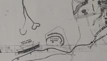
In the below picture another Cast Iron Water Tank can be seen directly below the tramway (you need to zoom in to see it clearly) I estimate its location to be near where Severn Villa is today
Well spotted - they're
Well spotted - they're popping up all over!
More about water tanks and reservoirs
In 2003, works were proposed to improve the Hong Kong mid level and high level areas water supply.
In this document, the existing installations are listed under the header “The Bowen Road group high level fresh water supply system”. It consists of:
· Bowen Road Fresh Water Pumping Station
· Magazine Gap Road Fresh Water Pumping Station
· Severn Road Fresh Water Pumping Station
· Magazine Gap Road Nos. 1 and 2 fresh water service reservoir
· Severn Road fresh water service reservoir
· Mount Gough fresh water tank
· Wan Chai Gap Road fresh water tank
· Barker Road fresh water tank
and associated water mains
To this proposal, a map was added, unfortunately in poor quality, and only showing the improvements planned. From this map, the fresh water reservoirs can be found easily. I’ve made places for both.
Tanks (octagonal ones?) are not shown, up to now only the Barker Road one has been found. Two more to spot!
P.S. Could Mount Gough fresh water tank be this one?
I believe that arrow is a
I believe that arrow is a family symbol of Sir Henry Sidney. It is also used in British Hong Kong as colony government property symbol.