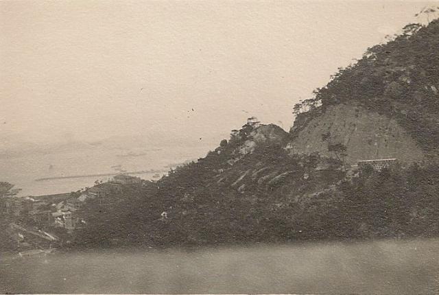
As with the previous photo that I posted, I'm unsure of the reason for this photo taken by a member of the Warren family. It appears to focus on a part of the hillside. I can't make out if the structure is a building or a retaining wall. The only large 30s building project, in which CE Warren & Co. Ltd participated, as far as I'm aware, was Eucliffe Castle. I don't know if this photo shows the relevant site. Any ideas very welcome.
Jill
Date picture taken
1930s
Gallery
Comments
Tai Hang Road
The road cutting, I presume is Tai Hang Road. Causeway Bay Typhoon Shelter can be seen.
I agree with Moddsey, and
I agree with Moddsey, and think the photographer is looking north from somewhere near the junction of Tai Hang and Broadwood Roads.
Regards, David
Earlier than 1930s?
I'm now wondering if this photo is earlier than the 1930s, but am not sure which structure is the typhoon shelter and don't know when it was built.
The following SCMP extract dated 16 September 1913 about the purchase of a Tai Hang lot by C. E. Warren is cited by my cousin, Brian Lewis, in his unpublished "History of the Warren Family etc". I'm wondering if it has any relevance to the excavation shown in our mystery photo, i.e. whether the photo shows either of the lots in the process of being developed. Moddsey mentions the Tai Hang Road.
"Two important sales of Crown land took place at the Public Works Department yesterday, when the proceedings were marked in each case, not only by brisk bidding but by Chinese competition with the foreigner. The lots are situated in Wongneichong Road (near Calvary) and in Tai Hang Village respectively, and both have been sold for a term of seventy five years, with the option of renewal for a further term of seventy five years.
The Tai Hang Village lot, about 20,250 sq. ft. in extent, with an annual Crown rent of $210, was productive of smart competition. This lot was exposed at an upset price of $5063 or 25 cents per foot. Bids of $100 came rapidly until the lot was eventually sold to Mr. C.E. Warren at $7100, which works out at about 35 cents per square foot. It is, we learn, the intention of Messrs. Warren and Co, sanitary engineers, tile makers, etc, to build on the lot just acquired a modern tile factory, equipped with up to date plant, in extension of the factory which they built a few years ago and which has already become inadequate for the growing requirements of their business".
Lewis comments that the Wongneichong lot became Broadwood Road and area.
We hardly have any photos from pre-1920, so I'm expecting to be told I'm on completely the wrong track .....
Jill
Re: Causeway Bay Typhoon Shelter
Hi Jill,
I believe that was the original typhoon shelter. According to this wiki entry the original typhoon shelter was build before the turn of the century. It was likely East Point by the left edge of the photograph. The original break water become the new shore front when the shelter was filled up to be the Victorial Park in the 1950's.
Maybe the buildings on the small hill (probably the present day Fontana Gardens) could help to date the photo.
You might like to take a look at this photo from the opposite point of view. Unable to determine the location of the photographer though.
T
Re: Approximate location of the photographer
Hi there,
After looking at Google Maps as well as Jills photo, I beieve the cut-away shown is the slope just before Tai Hang Road meet Tai Hang Drive. In this respect the photographer was likely standing somewhere near the junction of present day Perkins Road.
T
Re: Tai Hang Village Lot
If Warren Street in Tai Hang is named after the Company, which I think was the case, the Tai Hang Village lot that was purchased is not in the photo.
Do I.L. numbers help the elimination process?
Thank you both tngan and moddsey for sharing your detailed knowledge of early HK geography. It’s useful to know that the typhoon shelter predates 1913. And yes, I understand that Warren Street was originally the approach road to the CE Warren & Co. tile factory in Tai Hang, and that housing for the workers there may have been built in it by the company. The Rate Books give the odd numbers, 13-27 Warren Street as I.L. 2040 in the names of the partners, CE Warren and J. Olson, or "CE Warren & another," although no. 13 was sold to a Chinese buyer in 1916.
In 1916, nos. 16, 17 and 12 Broadwood Road actually appear on the same Rate Book page as Warren Street as I.Ls. 2128, 2127 and 2132. CE Warren is here given as having sold 16 Broadwood Road to CS Gubbay. I assume that one of the Wongneichong lots mentioned in the SCMP article was the large I.L. 1947 on which nos. 8-21 Broadwood Road were built, (excluding nos. 12, 16, 17 and 18) - the so-called "Ridge building scheme" mentioned in my grandfather's obituary. In 1916 the new Broadwood Road is described as “Leighton Hill near Wong nei Chung outside City boundary”.
Is it the case then that the photo of the excavation has no connection with any of the above lots? I assume it doesn't show a part of Broadwood Road in the making, (but may be a later company project). I'd be most grateful for any more ideas on dating.
Jill
Re: location of photographer
Hi Jill,
At least the location of the photographer is within easy walking distance from Broadwood Road. It was (and still is) just a few bends away.
T
Getting closer ....
Ah ha! Thank you!
Jill
Re: Tai Hang Road
As tngan mentions Broadwood Road would be further west (left) of photo. Tai Hang Road is a rather narrow road (20 ft) that connects the Tai Hang and Wong Nei Chong Valleys to Jardines's Lookout. There are not many stopping places. I guess the blurry feature at the bottom is the road wall of Tai Hang Road. Perhaps taken from a passing vehicle.
Tai Hang Road cutting?
So the photo is taken from the Tai Hang Road, but the view is of another part of the Tai Hang Road near Tai Hang Drive? I'm assuming that the photographer was my uncle, Leslie Warren, as the photo came from his collection. The cut-away of the hill might then be the first stage of a C.E. Warren & Co. Ltd. building project, the reason for the photo being practical rather than aesthetic. The granting of applications to build on Crown land that I've seen are always heavily conditional on shoring up any cutaway hillside to make it secure and safe in time of rain. I wonder what was built on this spot.
Jill
View from Tai Hang Road
The road cutting on the right of photo as suggested was for the construction of Tai Hang Road. Prior to the bend appears a road wall. The view below is of the eastern valley of So Kun Po. The 3 distinctive houses in the photo at different levels suggests that the buildings are the ones above Eastern Hospital Road as seen here and in this photo . Unfortunately, Broadwood Road is not in view..
Re: Approaching Tai Hang Drive from Tai Hang Road from the South
Hi Jill,
I believe Tai Hang Road had been widened over the years. But you may take a look at this Street View approach from the South. Please go back and forth and note the wall on the right hand side looked old, especially the stone wall sections. If you go forward along Tai Hang Road you should be able to see a rocky face by the left. That is likely the cut out section of the slope shown in your photograph. Present day Tai Hang Drive is just round it.
Couldn't have a solid fix of the phographer but it should likely be somewhere around the present day gasoline station and Perkins Road.
On the other photo I quoted looking from the harbour towards Causeway Bay, the Tower was visible dispite a bit blurred. You may also see the spoils of the hill cutting along Tai Hang Road in a few places..
T
Thank you!
Thank you both, modssey and tngan, once again for sharing your expertise. Why this photo was taken and then preserved in Leslie Warren's personal collection still remains a bit of a mystery, but thanks to you. we now know what it is of. In due course I'll try to find out about the dates of the Tai Hang Road developments in case the photo belongs in the 1920s gallery. To be continued ....
Jill
Re: Naming of Tai Hang Road
Hi Jill,
A bit more information. Found a Chinese site saying Tai Hang Road was named on 13th February 1931. Thus depends on the date, it would seem Tai Hang Road was still under construction in late 1920s.
On the other hand, look what I've found. The present day location had been widened, but it might be the same low stone wall shown in the photo above,
T
1931 naming of Tai Hang Road
Good to know that Tai Hang Road was only named in 1931. Thanks tngan. I can't make a judgement about the wall. Moddsey thought the photo might have been taken from a car window which, if the blurred foreground object is a wall, would mean it was at least car window height. It may even be the car window itself. I'm slightly puzzled about the purpose of the distant free standing section of wall shown in the photo and why there isn't more of it. As it stands five or six stones in height, it would seem to be complete and quite high. Was it usual practice to build small sections of wall to catch land slips perhaps?
jill
Re: Stone Wall
Hi Jill,
Such stone walls were quite common on older roads on the Island as a barrier preventing people or vehicles from falling down the slopes, I think. I think the Government ceased to built these decades ago. Like this on the Peak, and this one along Repulse Bay Road.
T
Protective walls
Hello again, tngan,
You may well be right about the old wall that you've discovered, if it extends further down to where the eye can't see from the road side. It's certainly about the same number of stones horizontally (about 15), although the distant wall in the photo is about five stones high rather than three. In Ceylon, to where my Hong Kong-born father emigrated, it was common for "upcountry" British tea planters on their way home by car in the dark on the steep winding roads, to go "over the cud" (not sure of the spelling of the local word "cud"), when they had had one whisky and soda too many.
Jill
Local Ceylonese Whisky
Arrack.
Going over the "cud"
The British (or maybe Scottish) planters, actually brought their own whisky with them - or at least there were originally no exchange controls to stop them importing it. When, in the 1960s, British bank accounts were frozen, expenditure tax introduced, and living in Ceylon became more and more difficult , the Brits still working in my father's company made the decision that their trigger to leave the country would be when their stocks of Scotch ran out. The "cud", as I remember it, was the edge of the road, where there was nothing between it and a steep drop. As a child, I would occasionally hear my father saying that "so-and-so had gone over the cud in the night". I'm sure arrack produces the same result.
Re: Tai Hang Road low stone wall
Hi Jill,
I suspect the padestrian west of the stone wall was a later addition when they further widened Tai Hang Road or fixed the slopes for the former Wesly Village or even when the previous version of the Government Stadium down there was built. I will try to see if I could find out what's behind those tall fence. If only at some time when road maintenence dig up the concrete around the wall and then we shall see how deep it is.
On the other hand, I think the longer stretch of low stone wall at Robinson Road is similar. It may have already been there before the pedestrian was built.
T
It's very kind of you!
It's very kind of you to go to so much trouble!
JIll
Re: Another stretch of Tai Hang Road with low stone walls
Hi Jill,
Further west along Tai Hang Road, there is a longer stretch of low stone wall. These extended down to the slopes vertically.
Please a screen capture from Google Earth's elevated view.
T