Current condition
Ruin
Date completed
(Year is approximate.)
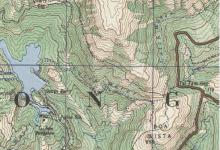
I had no knowledge of this location. But it appeared on the War Office Map Tai Tam area, denoted by 'Police Sta.' Near Gauge Basin and the Tai Tam Bungalow
Anyone have any info on this? I have never seen any remenants of this site, nor heard of it before.
Thanks
Photos that show this Place
2020
????
????
Comments
Pumping station?
Could they have mis-printed pumping station?
It would be a very odd place to have a police post, let alone a station unless this was a WSD police/security post of some sort?
Re: Police Station
Not a police station that normally comes to mind. Had a quick glance through HKGRO. There is a mention of a Taitam Police Station and a Tytam Tuk Police Station in 1892 and 1934 respectively. Not sure if they were the same police station.
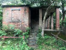
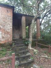
Tai Tam Police Station
It's the red brick, single storey building that lies a few meters off and to the right of the road as it climbs the hill from Tai Tam Tuk Reservoir, just before it reaches the Byewash Reservoir.
I've nudged the marker a
I've nudged the marker a short distance north-west so it's over the building on the old map:
http://gwulo.com/node/33077?a=1#17/22.25510/114.21365/Map_by_ESRI-1952_…
Tai Tam Police Station
Saw that building today. There is a sign that says building is from 1920s and they believe it was a police station. But why would there be a police station in this location? And what is that weird low building next to It?
Tai Tam Police Station
Hello I’m purely thinking out loud here - and I may be completely wrong - but I would like to put forward a suggestion regarding why the authorities may have erected a Police Station in such a remote area.
When the Government constructed reservoirs on the island, Hong Kong was nowhere near as heavily forested as it is now. Villagers had, for centuries, used wood for such purposes as fuel for cooking and heating and also the manufacture of charcoal, to name but two.
The authorities had, therefore, been required to plant trees around these reservoirs to prevent spoil from the hillsides being washed down and silting them up during the rainy season. In order to prevent these trees from being cut down, the authorities had to employ police officers to patrol the hillsides surrounding the reservoirs and arrest miscreants.
Indeed, near the entrance barrier to Hong Kong’s first reservoir, (Pokfulam), is the original “Watchman’s House,” now used by the W.S.D. There is a photograph on display outside showing a European Police Sergeant, (together with his wife), and Chinese and Indian constables who were responsible for policing the area in the late 19th century.
These days such duties would be conducted by “Park wardens” or “Park rangers,” rather than policemen.
Perhaps the building referred to as Tai Tam Police Station was “doing the same job” as the one at Pokfulam?
Tai Tam Police Station
I discovered this station on an old map printed in 1930s. After site inspection, I found a milestone nearby at the road side. The milestone erected sometime in 1840s. When I compare the map prepared in 1841 by British Army, I found out the reason supporting the need of this station.
In 1840s, there were two main routes connecting island south and north. The eastern route was from Victoria to Stanley via Tai Tam. There was a Tai Tam Village with 12 villagers lived there. The western route was from Victoria to Aberdeen via Pokfulam. Pokfulam Village was a larger village at that time with 100 odd villagers.
The role of most early police stations were to control major traffic routes, just like military did. In addition to the building of reservior later, a police station to safeguard the water supply, the need was seen.
We might find evidence that every reservior had a police station nearby.
Pokfulam Police Station
I was also misled by the photograph display outside the “Watchman’s House” . When you compare the photo with the actual building, you can find the buildings are different.
From the 1930s map, the location of the police station was situated next to Pokfulam Road. I had conducted a site visit and confirmed that the site should be inside the carpark nowadays.
Watchman’s House
I disagree with your assertion that the building shown in the photograph at the Watchman's House at Pokfulam Reservoir is different from the original one, constructed in the Victorian era. Of course, structural changes have been made over the years.
Do not forget that Pokfulam Reservoir was the first one constructed in the Colony, in 1863.
I think it also worth reiterating a point which I have made above, which is that these buildings were constructed to house those Police officers whose job it was to ensure that villagers were not cutting down trees planted by the Colonial authority to prevent the reservoirs from silting up from the spoil coming down from the surrounding hillsides, particularly during the rainy season.
Pokfulam Reservoir Watchman's Cottage
Hi Jade,
Referring to your observation that the photo on the signboard outside the Pokfulam Reservoir Watchman's Cottage is not of that building, please see the same photo at the "place" page for Pok Fu Lam Police Station (sorry I can't seem to get a link to work) along with comments identifying it as taken there. Well spotted!
re: Pokfulam Reservoir Watchman's Cottage
Here's the link to the photo gw mentioned: https://gwulo.com/node/15485
Jade LING, is that milestone
Jade LING, is that milestone at L22.256 and L114.2126?
"Kwan Tai Lo" Milestone
Made a place for the milestone here
"Kwan Tai Lo" Milestone
I was engaged in ground work during the year. From "mapviewer hong kong", you can found evidence of police stations on different maps. On 1845 map, you can see three main routes running between Victoria City and Stanley. I caslled it Kwan Tai Lo East route, South route and West route. Along the routes, 45 bridges were marked. Until now, 8 such bridges and 4 bridge remains were located. Kwan Tai Lo routes were also marked on recent map. I shall publish the report soonest.
Along the three routes, aq number of police stations were also found on the maps since 1845. Evidence shown that policemen were deployed by the side of main routes to control the movement of traffic and people.