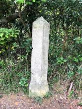
A British garrison was stationed at Stanley shortly after Hong Kong was ceded to Britain, although there was only a horse-path linking Stanley to the City of Victoria. This path was later upgraded to a road and a number of milestones were placed along the road, only which three have been found.
The first was discovered in 1966 embedded in the wall of a squatter hut near Kellett Bay (probably not in its original position). The second was discovered in 1981 in situ close to Tai Tam Road, north of Turtle Cove but had to removed due to construction work in the area. The third stands in its original place in the Tai Tam Reservoir area.
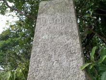
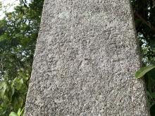
These stones are the earliest milestones from the British period and are therefore of considerable interest, They are large granite stones, triangular in cross-section and measuring 1.5 metres in height above the ground. Two of the faces of each indicate the distance to Stanley and the other to Victoria in English and Chinese in miles and "lei". The "lei" is a Chinese measure of approximately 0.3 of a mile. The Chinese name on the stone, "Kwan Tai Lo" is puzzling and has caused much speculation and theories. One has it this was the Chinese name for Hong Kong Island used during the Ming and early Ching dynasties.
The milestone on display in the Hong Kong Museum of History was re-discovered in the early 1980s (???) in a squatter hut in Shek Pai Wan. The distance to Aberdeen (1 mile) and to Victoria (5 miles) are inscribed on either side in both English and Chinese. See https://www.devb.gov.hk/filemanager/en/content_1044/20200322_03.html
1. In Search of the Past: A Guide to the Antiquities of Hong Kong by Solomon Bard
2. Information panel on "Kwan Tai Lo" in the Hong Kong Museum of History
3. See https://www.hkmaps.hk/viewer.html and select the 1902 Hong Kong map on top left to view a few of the early milestones on Hong Kong Island with distances to and from Victoria and Aberdeen.


Comments
Update on Kwan Tai Lo Milestone
I thought that some “gwulo” followers might be interested in the following development.
I am a member of a “Wednesday Walking Group” in Hong Kong, mostly retirees and HK residents, and we take it in turns to lead hikes in the SAR. A few weeks ago it was my turn, and I chose a route through the Tai Tam Country Park.
As we passed this milestone, I said a few words on its history - mostly facts gleaned from this website.
One of the group commented that it was a pity that the inscription(s) on the milestone were difficult (although not impossible) to read. Upon returning home he wrote to the Government, pointing out that this was an important historical artefact in the SAR and one of the very few of its type still in its original location.
He further suggested that it would be a good idea if Government were to place a bilingual information board next to the milestone, containing such information as included in Moddsey’s comment above.
I am pleased to write that he has now received a reply from the relevant Government department, thanking him for his suggestion and stating that they fully concur with it. The department has promised to action this suggestion and place an appropriate board at the location soon.
“Watch this space,” as they say!
Re: “Watch this space”
When I walked down the Tai Tam Waterworks Heritage Trail in November 2025, I "watched this space", but there was no information board. Maybe next year.