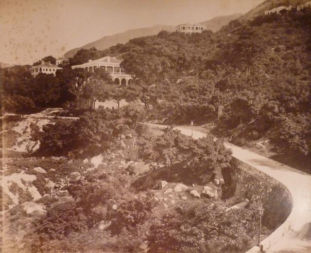
This is Hospital Road, not Caine. The building on the ridge at upper centre right also appears in the 1930s view. . Bonham road does not seem to exist here and the two storey building hidden behind the trees is roughly where the Hop Yat church now stands. The peak ridge line matches exactly
Not 100% sure on this, it’s the building above and to the left of Beauregard. It could also be the next house heading up Seymour Road on IL576 where the Dominican priory was later built. http://gwulo.com/node/21928. I have created a place for it here: http://gwulo.com/node/32466 I can’t read the name on the copy of the 1901 map here, http://www.hkmaps.hk/mapviewer.html Does anyone have a higher res copy?
Heading up Hospital Road there is a lamppost roughly in the middle of the picture. To the right of this a stone wall is just visible behin some bushes out. This is an octagonal water tank at the top of Pound Lane between Bonham and Hospital Road. http://gwulo.com/node/32464
Hospital Road is definitely the road shown in the lower photo, Bonham road is completely flat while this one curves up the hill.Bonham road is in this picture but it is almost completely hidden by bushes and trees.
I also don't think you can see the Mission House in the photo, the white part is the retaining wall of Beauregard with a couple of people in-front of it
The stone water tank can be seen in both photos, in the later one its next to the lamppost on Hospital almost hidden by trees
The Martin Gregory photo was taken on Bonham Road itself, close to where high street join. The earlier photo was taken on the hillside above Bonham/High Street junction
The white London Mission building in the 1870s photo is on Bonham Road where today the entrance driveway to 80 Robinson Road is. Bonham Road and Hospital Road are very close here, there is only a retaining wall and about 6 feet in height separating them. The Bonham-Caine-Seymour-Hospital Road junction is just off to the left of the picture. The No 8 police station is also out of site to the left of the photo, luckily Martin Gregory's photo was a double set so here is the view to the left:
The No 8 police station is the large building in the top right of the picture with 2 Chimneys. It did not become the no 8 police station until 1895 or so previously it had something to do with the marine police or harbour master. Something marine
I will post another photo that shows both buildings in the same shot
The below photo shows both the London Mission 'Chapter House' South of Bonham Road at Q and the No. 8 Police Station (2nd generation) north of Hospital Road at N
Comments
Hospital Road
This is Hospital Road, not Caine. The building on the ridge at upper centre right also appears in the 1930s view. . Bonham road does not seem to exist here and the two storey building hidden behind the trees is roughly where the Hop Yat church now stands. The peak ridge line matches exactly
Thanks for the corrections, I
Thanks for the corrections, I'll update the names now.
Regards, David
Please Add Places
Please add the Following Places to this picture
Beauregard http://gwulo.com/node/31734
Big House in centre of Picture
Idlewind: http://gwulo.com/node/5013
Not 100% sure on this, it’s the building above and to the left of Beauregard. It could also be the next house heading up Seymour Road on IL576 where the Dominican priory was later built. http://gwulo.com/node/21928. I have created a place for it here: http://gwulo.com/node/32466 I can’t read the name on the copy of the 1901 map here, http://www.hkmaps.hk/mapviewer.html Does anyone have a higher res copy?
The building hiding in the trees just behind is likely “The Hut” : http://gwulo.com/node/5007
The Building Top centre right is Burnside; http://gwulo.com/node/5726
Top Right buildings are Marlingford: http://gwulo.com/node/5058
And Cringleford (can only see half): http://gwulo.com/node/5059
The roof of the building on the far left of the photo is likely the castle: http://gwulo.com/node/5006
Heading up Hospital Road there is a lamppost roughly in the middle of the picture. To the right of this a stone wall is just visible behin some bushes out. This is an octagonal water tank at the top of Pound Lane between Bonham and Hospital Road. http://gwulo.com/node/32464
Hospital Road is definitely
Hospital Road is definitely the road shown in the lower photo, Bonham road is completely flat while this one curves up the hill.Bonham road is in this picture but it is almost completely hidden by bushes and trees.
I also don't think you can see the Mission House in the photo, the white part is the retaining wall of Beauregard with a couple of people in-front of it
The stone water tank can be seen in both photos, in the later one its next to the lamppost on Hospital almost hidden by trees
The Martin Gregory photo was taken on Bonham Road itself, close to where high street join. The earlier photo was taken on the hillside above Bonham/High Street junction
That makes the whitewashed
That makes the whitewashed building Police station No 8 ? It is on Hospital road so it is not on London Mission property. http://gwulo.com/node/20883
Here are cropped photos showing the roof of Beauregard in both photos.
The white London Mission
The white London Mission building in the 1870s photo is on Bonham Road where today the entrance driveway to 80 Robinson Road is. Bonham Road and Hospital Road are very close here, there is only a retaining wall and about 6 feet in height separating them. The Bonham-Caine-Seymour-Hospital Road junction is just off to the left of the picture. The No 8 police station is also out of site to the left of the photo, luckily Martin Gregory's photo was a double set so here is the view to the left:
The No 8 police station is the large building in the top right of the picture with 2 Chimneys. It did not become the no 8 police station until 1895 or so previously it had something to do with the marine police or harbour master. Something marine
I will post another photo that shows both buildings in the same shot
The below photo shows both
The below photo shows both the London Mission 'Chapter House' South of Bonham Road at Q and the No. 8 Police Station (2nd generation) north of Hospital Road at N