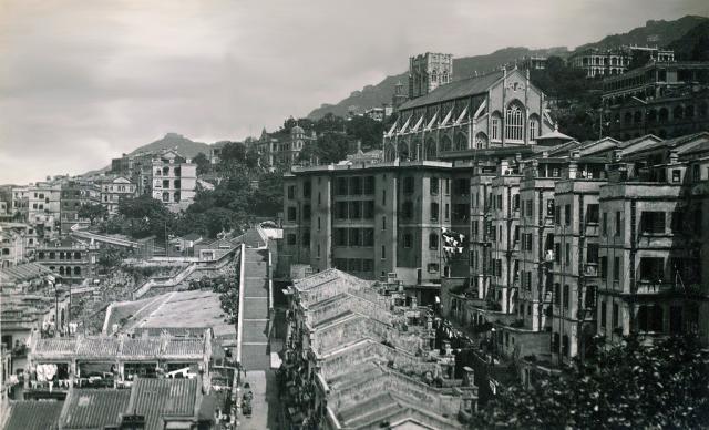
moddsey Thu, 11/20/2014 - 08:51 prevnextoldernewer Date picture taken 1935 Author(s) Moddsey Gallery 1930s Hong Kong Shows place(s) Bacteriological Institute / Pathological Institute / Hong Kong Museum of Medical Sciences [1906- ] 147 Caine Road [????- ] Holy Spirit School, Caine Road [????-????] Caine Lane Garden [????- ] Dominican Procuration for Missions (I.L. 576 R.P.) [????-????] 4, Hospital Road [1921- ] Hop Yat Church [1926- ] Burnside - Choa family home [1880-????] Rutter Lane Terrace [????-????] Hospital Road Terrace (1st Generation) [????-????] Beauregard - London Missionary Society (LMS) Compound - IL 590 [????-????] Ying Wa Girls School [????-2016] Ohel Leah Synagogue [1902- ] Shows street(s) Rutter Street [c.1870- ] Log in or register to post comments Comments Hop Yat Church Hi Moddsey, This one should be a bit further west - Hop Yat Church on the right, and a view of 147 Caine Road and the Bacteriological Institute in the distance. Regards, David Log in or register to post comments Re: 1930s Caine Road Hi moddsey, I am a bit lost. Where are the steps in the centre? In the Tai Ping Shan area? Thanks. Log in or register to post comments Updated Thanks and updated. Yes, looking at the Tai Ping Shan area below. If David would redirect the photo to the proper thread. Log in or register to post comments New Places Can you please add the following places to this photo Burnside: http://gwulo.com/node/5726. Top right of picture Rutter lane Terrace : http://gwulo.com/node/32412 Rutter Lane runs down the centre of this picture, Rutter Terrace is the row of buildings to the right. Hospital Road Terrace (2nd Generation): http://gwulo.com/node/32462 Row of 5 story Buildings on right of picture Beauregard: http://gwulo.com/node/31734 Below Ying Wa Girls School. Not 100% sure that this is Beauregard- its located roughly where the current Pastors house is behind Hop Yat Church. I think Beauregard may have been where Hop Yat Church is now and this was a later building. Ying Wa Girls School: http://gwulo.com/node/31104 The 1927 Block – Below to the right of Burnside Ohel Leah Synagogue: http://gwulo.com/Ohel-Leah-Synagogue One tower is visible just to the left of the Hop Yat Church Tower Log in or register to post comments All Included All included. Keep up the good work! Log in or register to post comments Almost the same view, but 30 Almost the same view, but 30 years later: View fron the Tung Wah Hospital Building, by Eternal1966 Log in or register to post comments
Hop Yat Church Hi Moddsey, This one should be a bit further west - Hop Yat Church on the right, and a view of 147 Caine Road and the Bacteriological Institute in the distance. Regards, David Log in or register to post comments
Re: 1930s Caine Road Hi moddsey, I am a bit lost. Where are the steps in the centre? In the Tai Ping Shan area? Thanks. Log in or register to post comments
Updated Thanks and updated. Yes, looking at the Tai Ping Shan area below. If David would redirect the photo to the proper thread. Log in or register to post comments
New Places Can you please add the following places to this photo Burnside: http://gwulo.com/node/5726. Top right of picture Rutter lane Terrace : http://gwulo.com/node/32412 Rutter Lane runs down the centre of this picture, Rutter Terrace is the row of buildings to the right. Hospital Road Terrace (2nd Generation): http://gwulo.com/node/32462 Row of 5 story Buildings on right of picture Beauregard: http://gwulo.com/node/31734 Below Ying Wa Girls School. Not 100% sure that this is Beauregard- its located roughly where the current Pastors house is behind Hop Yat Church. I think Beauregard may have been where Hop Yat Church is now and this was a later building. Ying Wa Girls School: http://gwulo.com/node/31104 The 1927 Block – Below to the right of Burnside Ohel Leah Synagogue: http://gwulo.com/Ohel-Leah-Synagogue One tower is visible just to the left of the Hop Yat Church Tower Log in or register to post comments
Almost the same view, but 30 Almost the same view, but 30 years later: View fron the Tung Wah Hospital Building, by Eternal1966 Log in or register to post comments
Comments
Hop Yat Church
Hi Moddsey,
This one should be a bit further west - Hop Yat Church on the right, and a view of 147 Caine Road and the Bacteriological Institute in the distance.
Regards, David
Re: 1930s Caine Road
Hi moddsey, I am a bit lost. Where are the steps in the centre? In the Tai Ping Shan area? Thanks.
Updated
Thanks and updated. Yes, looking at the Tai Ping Shan area below. If David would redirect the photo to the proper thread.
New Places
Can you please add the following places to this photo
Burnside: http://gwulo.com/node/5726.
Top right of picture
Rutter lane Terrace : http://gwulo.com/node/32412
Rutter Lane runs down the centre of this picture, Rutter Terrace is the row of buildings to the right.
Hospital Road Terrace (2nd Generation): http://gwulo.com/node/32462
Row of 5 story Buildings on right of picture
Beauregard: http://gwulo.com/node/31734
Below Ying Wa Girls School. Not 100% sure that this is Beauregard- its located roughly where the current Pastors house is behind Hop Yat Church. I think Beauregard may have been where Hop Yat Church is now and this was a later building.
Ying Wa Girls School: http://gwulo.com/node/31104
The 1927 Block – Below to the right of Burnside
Ohel Leah Synagogue: http://gwulo.com/Ohel-Leah-Synagogue
One tower is visible just to the left of the Hop Yat Church Tower
All Included
All included. Keep up the good work!
Almost the same view, but 30
Almost the same view, but 30 years later: