The source of the image on flickr is: https://www.flickr.com/photos/129372920@N08/17468774262/ with the title: "4-5-52- Hong Kong". The original image shows colour faults, on the displayed one it's corrected.
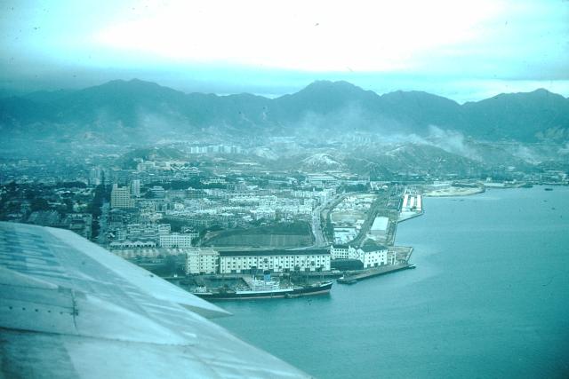
Nice aerial view showing southern and eastern shores of TST. Near the wing is Holt's Wharf, behind it Signal Hill. In the back there could be Chatham Road Camp. The barracks at the eastern shore are unknown to me.
Source: This image came from Flickr, see https://flickr.com/photo.gne?id=17468774262
Date picture taken
1952
Gallery
Shows place(s)
Comments
Aerial view of Kowloon
The aircraft's registration on the wing appears to be N8888. Googling this just brings up a modern Biz-jet so the registration must have been reused. The part of the engine cowling seen in the view looks like that of a Douglas C47 Dakota. Assuming the aircraft is American, it may be a Northwest Airlines aircraft operating out of Korea at that time.
RE: Aerial view
Given the photo had been taken in the 1950s, the aircraft would have entered the harbour from the east via Lyemun Pass before turning right over Kowloon to land on the longer of the dual runways at Kai Tak,
Aerial view of Kowloon
It appears that I misread the aircraft's registration on the wing. It should be N88888 ie with an extra 8
This makes it Pan American Airways C54 (DC4) named Clipper East Indian or Clipper Bonita.
It had a number of Clipper names over time. Built in 1945.