Current condition
In use
Date completed
(Day & Month are approximate.)
Timeline for the tower, extracted from the comments below:
- 1907: 3-storey tower with flat roof built. Timeball operated on roof.
- 1928: April - October, 4th storey with round window, and dome-shaped roof added to raise the height of the timeball so it could be seen from more locations.
- 1933: Timeball removed as the Observatory switched to using radio to transmit time signals.
Booth mentions being able to see the tower - and its 'inverted T' typhoon signal - from his position next to the Peninsula Hotel. The Sheraton Hotel obscures the view today.
Photos that show this Place
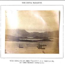
1868
1905
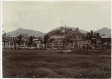
1905
Comments
"Familiar Landmark" ?
This tower still exists, but would anyone call it part of our 'collective memory'?
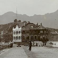
"This familiar landmark, built in 1907, stands prominently on a rocky hill in Kowloon known as the Blackhead Point. A large copper ball, seen on top of the tower, was used for time signals for the ships in harbour (before 1907 the time-ball was housed in a similar tower in the grounds of the Marine Police Headquarters). A time signal was given daily at precisely 1 p.m. by the dropping of the ball from the top of the pole to the bottom. this maneuvre would be observed by the ships in harbour. This method of signalling time was replaced, in 1933, by radio signals. The Tower, a handsome three-storeyed, red-brick structure, is part of the Royal Observatory complex, but has never been used for astronomical purposes. The 4th storey and a dome were added to the Tower in 1927. Note the attractive old colonial-style, spacious private residence at the bottom of the hill."
More photos & info
are available at Place "Signal Hill Battery / Blackhead Fort"
View from Signal Hill
The reason why Signal Hill location was selected was because it offered a panoramic view of the harbour at the time, all the way from Lei Yu Mun in the East to the west end of the harbour. Those views were later obscured by various buildings that grew up in front of the hill, making the Hill a less visible position. However, with the recent demolition of the New World Center, and before something else sprouts up in its place, it might be an opportune time to pop up to the hill and tower with good wide angle lens to snap a few shots, at least of the eastern end of the harbour.
View from Signal Hill
Better still make a few panorama images. Easy to do today with modern cameras, even with the digital compact ones. Needs a clear day though.
Signal Hill
In the splendid run of images of Signal Hill, three are misdated. They are the three between the 1927 photo and the one for 1936 showing the saluting battery. Careful inspection shows that all the images have a timeball tower of only three levels with the top storey windows rectilinear. In 1928 the additional, fourth story was added (to recover lost sightlines as a result of new buildings in the surroundings) at a cost of HK$5405 and its windows were circular. What is unclear (because there is no photograph) is whether the cupola was installed with the increase in height or only after the timeball was dismantled on 30th June 1933. Either way, from 12th October 1928, when the timeball went back into operation after six months' suspension, the tower had four storeys with circular windows in the uppermost. It follows that the photos dated to the 1930s with rectiliniear windows in the top storey, as above, are misdated. They must be pre-1928.
StephenD
re: Signal Hill
Thanks Stephen, I'll update those photos next.
I found a mention of the work to raise the tower's height in item 140, the 1928 Annual Report for the PWD.
Regards, David
Signal Tower
Thanks David. I have chapter and verse on the exercise (including the name of the contractor: Tat Lee & Co.) but so far no actual details of the plans. HWD was responsible for the overhaul and improvement of the timeball machinery (and presumably for the installation of the new telegraph cable from the HKO to Signal Hill). What I haven't found are two things.
One is any plans of the new installation to show whether the cupola we can see in photos from c.1935 onwards was part of the original height increase design. The other is any photo of the newly raised tower taken without any shadow of doubt between its entry back into service on 12th October 1928 and its being taken out of service on 30th June 1933. Either would resolve the issue of whether the cupola was installed in 1928 or later.
A second point related to that - given what is there today, is what exactly the cupola was - I'm assuming shelter of some sort for the machinery and operators. I somehow have the impression (possibly entirely mistaken) that the original may have been some sort of timber structure clad in copper sheeting (the verdigris of which is what the present green paint is supposed to imitate)
StephenD
I'm not sure about how the
I'm not sure about how the cupola was made, but see this photo dated 1932 shows the cupola in place:
Regards, David
1930s Signal Hill
According to the 1928 HKO Annual Report, the Time Ball Tower was raised by 20 feet between 29 April and 10 October 1928.
time ball tower
Thanks Moddsey. I have that data, the puzzle was whether the cupola was part of the extra floor design or a post-timeball add on. It appears from the photo of the Oswald, since the photograph's dating seems secure, that it was the former. I've also learned from a note put together by Robyn McLean, when she and Ian Diamond headed up the old PRO at the top of the Murray Road Car Park, that it was "designed in the Georgian manner" by A.C. Little of the PWD, was 42' 6" high (before the added "around 20 feet") and "square except as regards the treatment of the angles which are splayed off". The walls are of Canton red brick, with Amoy (Xiamen) red brick facing and granite (no provenance) facings.
Arguably one of the more interesting elements of the new timeball tower was that it was (and is) within just a few metres (under 20) of the Hong Kong Local Meridian, which was used to set HK Local Time (aka Hong Kong Civil Time) from 1884 until HK went onto the new international time zone system on 30th October 1904. At that moment Hong Kong Mean Time was tied to that of the 120th meridian, 8 hrs in advance of Greenwich and the old local meridian, 7hrs 36 mins, 41.86 seconds ahead of Greenwich, abandoned.
This actually raises another interesting little problem for Gwulo readers. To establish the old HK Civil Time, what was needed was a regular transit check on HK's longitude. This was best done using the 67 'clock stars' and the transit instrument at the Observatory, but as a back up physical transit checks were established. The northern one was within the observatory grounds. The southern one, however, was 3.46 km away (11,354') on the 'side of a hill in Wantsai'. Our team at HKU's Dept of Real Estate and Construction is on the hunt for this, which was a white painted obelisk with, on its north face, two black circles with a vertical black line (I think between them - the description is not lucid!). We know to within 20-30m where it must have been - somewhere close to Bowen Road between 50m or so to the east of the junction with Wanchai Gap Rd and 50m or so west of the eastern exit of the steps coming up from Shu Fai Terrace. Our guess is that the obelisk will have been at least 1.5m tall (the telescope of the transit instrument had a c. 50x magnification) and so placed that it could not be washed away by a flood or zapped by a landslip, as well as being sufficiently firmly planted to be fixed very unbudgeably in position.
A scout the other day didn't spot anything (the big landslip of a couple of years back is perilous close to the most likely area), but that's probably because the obelisk has long since bitten the dust. We know it was in position until c.1941. We're fairly sure we shall be able to pinpoint where it was once we've translated all the old HK Datum based positions to today's WGS84, so that at least will identify the actual location (we have our suspicions).
Meanwhile, and anyway, if anyone can spot it on a photo or has ever come across an image of it, we should be delighted to learn whatever we can.
StephenD
Interesting Information
Interesting information provided. Thank you.
Blackhead Point
The small elevation where the time-ball Tower now stands known as Signal Hill is just above what is still called Blackhead*s Point. The origin of that name is interesting - it was derived from the surname of Mr, F. Blackhead, a local merchant who founded a firm of ship chandlers sailmakers, coal dealers, auctioneers, and so forth, known as F. Blackhead and Co. Which flourished up to about thirty years ago, when it occupied premises next to the old Hongkong Hotel on the seafront in a three storeyed building standing on part of the site of the present Gloucester Building.
The firm was a very old one, well established in the late Fifties. An early record ( dated 1860 ) gives Mr. F. Blackhead as absent at the time, with his headquarters in London. The premises occupied were then in Queen's Road West, the central site referred to above having been taken later. There was a branch establishment in the old days at Whampoa. But perhaps the most interesting thing about Blackhead's Point is that it is called after a German for the Gentleman concerned was of a German nationality An old record shows that Mr. B. Schwartzkopf changed his name to F. Blackheadon becoming anglicised. Evidently he proved a most desirable and loyal addition to the list of businessmen in the Colony identifying himself with much of the trade and shipping expansion of those early years. His anglicised name is, of course, a direct translation from the German and while the man himself is probably forgotten his memory is preserved in the point since become an inland hillock through reclamation which was named after him
Source: Old Hong Kong, by Colonial - There is much more information about Mr Blackheadon & his firm.
A stunning clear photo of 2
A stunning clear photo of 2 Chatham Road, Signal Hill and pre-cupola tower with time ball on Blackhead Point dated circa 1925
Signal hill and the meridian marks
Thanks all for the comments. I should have updated long since, but members of the Royal Asiatic Society Hong Kong, who will recently have received vol. 61 of the Journal, will have seen that the entire history of the built structures needed to operate it has now been uncovered and, out of the nine elements created to operate the Hong Kong Time Service between c.1883 and 1928, what remains of eight of them have been identified and, insofar as it lies within the competence and powers of the Hong Kong Observatory, will be preserved.
There is almost no chance either of AMO or the AAB will be involved since they declared themselves uninvolved in any "non-building/structure" not already covered by their existing remit (hence the Bishop Hill Reservoir fiasco - but theyv are HK civil servants, so slow to learn when they learn at all).
Sadly the ninth and central element, the Transit Room at the heart of the whole operation, was happily (!) demolished in 1979 to create an access roadway to the new high block built for an expanding, modernizing observatory.
That these eight important relics to HK's scientific heritage have been discovered owes a huge amount to the enthusiasm and commitment of the previous Director of the HKO (Shun Chi-ming) and a surveyor with the Survey and Mapping Office, Willie Yip Tsan-pong, who joined me in unravelling the full story and, truth to tell, did most of the work!
This is the HKO video made about it: https://www.youtube.com/watch?v=6r_pE6hlFSQ. As yet, however, it lacks the final hurrah, which will be a fifth part. While a fancy, granite sett meridian line was being installed at the HKO in 2020, we talked the contractors, with the help of the AMO (at last!), to go right through the roadway where the old Transit Room had stood, to see if we could spot the massive, five foot deep brick pier that stood beneath the transit instrument to ensure its stability. In late November 2020, BINGO! There were the remains, which enabled Willie Yip and his survey team to pinpoint to within millimetres (sorry for the mixed units of measurement) where the transit instrument had been centred - omphalos Hong Kong.
There were also traces of the brick 'cylinder' that had been built around the brick pier to ensure that not even a horde of stamping horses passing by (we're talking 1884) would impart the slightest tremble. Traces of eight out of nine elements of the original HK time service found and recorded - there is only a handful of such complete systems that have been preserved anywhere else in the world and, as far as we know, none at all in China bar in HK.
And yet, and yet...there was a postscript. On the very last day of 2020, stuck in UK by covid-19, I got an email from a consultant engineer, Ir Irene Or, who had been working with the CEDD's Geotechnical Services Office in 2008 as they dealt with securing the slopes above and below Bowen Road after the massive 2005 landslip that had come within ten or so metres of sweeping away the old South Meridian Mark. She'd planned to drill a test hole EXACTLY where the old south mark stood and was amazed when, arriving at her chosen location, she had found the elegant Victorian structure. Fortunately, unlike CEDD's normal approach, which is to ignore (or bullshit away (q.v. Tamar)) any bothersome traces of the past, bulldoze them and get on with the job, Irene knew that whatever it was must have significance, so reorganized her testing sequence to ensure the old south mark survived. She even got AMO to come and have a look (it took a week of patient telephoning before she found an AMO funtionary sufficiently interested to come and look). Needless to say, no record of this seemed to have survived, or it it had, to have been traceable, when in 2020 the Observatory sought the AMO's help over the remains of the brick pier and cylinder.
So for the survival of the old South Meridian Mark Hong Kong has to thank a thoughtful geotechnical engineer, who happily admits she hadn't a clue what she was seeing, but who is and was savvy enough to know that whatever it was, it shouldn't be trashed just because it was in the way of a concrete pouring project. Chapeau to Ir Irene Or.
Chapeau too to my fellow Meridiana Joneses, Shun Chi-ming and Wille Yip Tsan-pong who have helped ensure that the remaining traces of an important system in Hong Kong's scientific and commercial development - a precision time service - have been recorded and, where possible, preserved.
StephenD
Signal Hill Radio Monitoring Unit
NEW OFFICE FOR RADIO MONITORING UNIT AT NGAU TAU KOK - PROPOSED CONSTRUCTION OF - TO REPLACE THE SIGNAL HILL RADIO MONITORING UNIT
https://search.grs.gov.hk/en/arcview.xhtml?q=radio+monitoring+unit&eid=h4ixZGUP7wPEvfU4rekWyg%3D%3D&ls=q%3Dradio%2Bmonitoring%2Bunit%26e_k%3Don
RADIO MONITORING UNIT ACCOMMODATIONS - 1. R.M.U. PREMESIS AT BLACKHEADS 2. REMOVAL OF R.M.U. STORE AND WORKSHOP AT WEST FORT, WHITFIELD BARRACKS TO EX-NAVAL CAMBER, KOWLOON
https://search.grs.gov.hk/en/arcview.xhtml?q=radio+monitoring+unit&eid=5o8U17sl%2Biuf59iGrFf9aQ%3D%3D&ls=q%3Dradio%2Bmonitoring%2Bunit%26e_k%3Don%26page%3D2
According to above link of Government Record Office, a military radio monitoring unit was on Signal Hill. It moved to Ngau Tau Kok service reservoir in Kwun Tong in early 1960's. and changed to the site of radio monitoring unit of Post Office, then Office of the Telecommunications Authority OFTA and now Office of the Communiationcs Authority.
Ref. to Messrs. Blackhead & Co at TST
We observe a barque is now alongside Messrs. Blackhead & Co.'s wharf at Tsim Tsa Tsoi (sic) Point. We believe this is the first vessel which has been moored alongside this wharf.
Source: China Mail 16 October 1886
Over time, Tsim Sha Tsoi Point or Chinsalchui Point (east of Kowloon Point) would evolve into Blackhead or Blackhead's Point.