Current condition
Demolished / No longer exists
Date completed
(Day, Month, & Year are approximate.)
Date closed / demolished
(Day, Month, & Year are approximate.)
A big building, visible in the 19th century photos. It was a terrace of four houses.
It stood on part of IL 141. The full Lot was bounded by Arbuthnot Road on the east, Caine Road on the west, and a big staircase that connects the two roads running along the north side.
Previous place(s) at this location
Photos that show this Place
1886
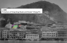
c.1888
c.1889
Comments
Lot 141 and 65 Information
I’ve done some more research on the two buildings
No sign of the buildings on the 1845 map, but the site has been formed between Arbuthnot and Caine Roads : http://gwulo.com/atom/16435
A tentative first sighting of the big building (Which I will call Lot 141 until a better name is found) is in an 1846 painting: http://www.lcsd.gov.hk/ce/Museum/Arts/documents/10284/368443/sou_A04.jpg
This seems to have been painted from the bottom of Wyndham and Queen’s. Is the building in centre distance behind the pagoda(?) the Lot 141 building. If so it would make it one of the oldest buildings in HK. The building just above and to the right also appears on the 1845 Map linked above on the uphill side of Caine so it’s in roughly the right place. The arches don’t seem accurate in the painting but perhaps some artistic licence was employed?
I’ve trawled all the 1850’s and 1860’s pictures but can find nothing conclusive.
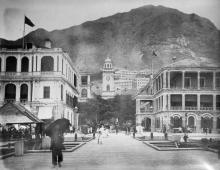
The earliest photo I can find is the 1870 photo of the Peddar Street Clock tower, the two buildings to the right of the Arch (Lot 141 half hidden by the tower itself) are the ones shown in the original Arbuthnot road photo: http://gwulo.com/atom/13051
Notice the triangular face with the circular hole in the middle of the roof on the right side of the right building as this makes it much easier to identify in later photos – This is Lot 65 building
The building roofs can be seen in the following photo in 1875, just below and to the right of the Gaol, almost hidden by trees: http://gwulo.com/atom/17290
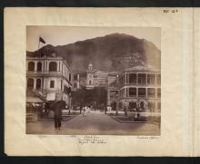
Another 1886 Shot where you can make out Arbuthnot Road clearly: http://gwulo.com/atom/13985
And another: http://gwulo.com/atom/19386
(Notice the progression of the New Catholic Cathedral in the previous two photos)
From Pedder street Wharf around the same date: http://gwulo.com/atom/20603
(right of the clock face)
A good 1890’s picture of the buildings: http://i.imgur.com/dRcmNSD.jpg
(from http://hongwrong.com/hong-kong-skyline-through-the-years/)
On the 1904 map, lot 141 building is shown divided into four:, while Lot 65 building is divided into two:
http://www.grs.gov.hk/PRO/imgroot/076%289%29.jpg
Unfortunately the map is not hi res enough to read the numbers, does anyone have a better copy?
The uploaded 1904 City hall clearly shows Lot 141 building in four distinct parts (from different levels of maintenance?)
This 1900’s postcard shows the buildings: http://gwulo.com/atom/16322, but does not seem very accurate
1906: http://gwulo.com/atom/19402
No outline of the buildings on this 1924 map http://gwulo.com/atom/14601 but the lots are numbered 141 and 65
However they are still standing in this 1922 Picture: http://gwulo.com/atom/19377
Roofs visible again in 1927 (bottom centre of photo right of Gaol): http://gwulo.com/atom/12873
A 1930 Picture: http://gwulo.com/atom/19378
The roofs are shown in the bottom right of the following 1932 picture: http://gwulo.com/atom/19371 (to the right of four tenement buildings on Caine)
Another photo taken from the other side: http://gwulo.com/atom/14702
This 1935 shot may indicate that at least the end furthest up the hill of the Lot 141 building has been demolished http://gwulo.com/atom/13752
After the war the building on lot 141 was at least partially demolished. My guess is only the unit closest to Lot 65 was still standing at this time.
Missing building in 1946 Hedda Morrison photo: olvwork348292 (just to left of dome)
But one end still survives: olvwork348291 (bottom right of photo to left of Cathedral – look for the triangular roof with the hole in))
The building on Lot 65 Still seems intact.
A great shot of the Lot 65 building: olvwork348158 (centre left of photo just above botanical gardens)
141 mainly is ruined/gone (a small piece of sloping roof still exists)
I have not found any evidence for the buildings after Hedda Morrison’s photos. As HK grows upwards the it becomes hidden behind taller, newer structures.
The last photo showing anything of the buildings was taken in 1964: http://gwulo.com/atom/16440
Through the Gap above the Glenealy buildings to the right of Alford House can be seen a building with a sloped roof. (This building is on the seaward side of Arbuthnot but just to the right of it, hidden in shadow is a ruined wall and a retaining wall. I think this is the final remains of whatever was originally built on the site. Cordial Mansion (on the end of lot 141) was completed in 1973. Universal Trade Centre (on lot 65) was completed in the early 1990’s)
My dates for the big building on Lot 141 would be 1846 – 1946/1950)
Lot 65 would be 1860’s – 1950’s
Can anyone supply more information on who built/ownedlived there?
That's a good trawl through
That's a good trawl through the maps & photos.
An 1897 map of the area shows these buildings are the odd numbers along Arbuthnot Road. I can't see any #1, then Lot 65 is #3 and #5. The four-building terrace is numbers 7, 9, 11 and 13, then there's another large building at the south end of Lot 141 that is #15.
Regards, David
Still there c.1970
Looking at a c.1970 photo of this area in the ISD photo library (their ref: CE218), number 7 is still there! So I believe it lasted until the site was cleared to build Cordial Mansion.
I've brought the demolition date forward to c.1971.
Regards, David