In this update for the CPS Project [1] we'll look at photos of the streets around the Central Police Station (CPS) site:
View CPS neighbourhood in a larger map
The neighbourhood
The CPS site is marked in dark blue, and the neighborhood around it in light blue. It isn't a big piece of land - you can walk across it in ten minutes or less - but it contained a great variety of people, living in very different circumstances.
Let's pick the 1870s and introduce some of the local residents that the policemen would have seen.
Saints & Sinners
Two of Hong Kong's biggest
churches, the Union Church and the Roman Catholic Cathedral, were nearby. The sound of their church bells would have been part of the police and prisoners' daily routine:

Then how about the red lines? They mark streets that in 1877 had one or more brothels [2].
Rich & Poor
Photos of the seafront and Queen's Road show the grand buildings of leading local businesses, and the organisations that served them. On the corner of Wyndham Street and Queen's Road stood the Hong Kong Club, and across from it were the Court House, the Post Office, and the Hong Kong Hotel.
But moving south / uphill from Queen's Road you'd pass through a densely populated area. Then towards the top of the neighborhood it would change again and you'd find detached houses with gardens, belonging to wealthy individuals.
You can get an idea of the differences from this 1874 map, where you see the plots of land get bigger as we move south / uphill from Queen's Road:

East & West
Pottinger Street runs from the shore to the CPS, splitting the neighborhood roughly in half. I've read that Pottinger Street was considered an informal boundary between the more European Central District, and the Chinese area to its west. That certainly seems the case in this 1920s photo of Queen's Road Central:

The photographer is looking west along Queen's Road from near the junction with D'Aguilar Street. If you click on the photo and zoom in, you'll see the shop signs change from English to Chinese as you move west along the road.
Old & New
The end of the 1870s saw huge changes in the neighbourhood. A great fire in 1878 destroyed close to a quarter of the shaded area on the map above:
"... it was about 10.5 acres in an area framed by Queen's Road, Pottinger Street, Hollywood Road and Peel Street. Rebuilding began in January 1879. [2]"

This engraving shows the fire in full flame. Can you see the building with two towers to the left of the smoke? That's the Roman Catholic Cathedral we noted earlier.
Then what photos are available to show us these streets, people, and buildings?
Photos - the view from above
Luckily for us the view from the Peak has always been a popular subject for photographers, and their photos often capture the CPS and its surroundings.
Here is a sequence of these photos taken over the years, showing the changes in the area. (Click any photo to see its source.)
1865. The photographer wasn't as high as the Peak, but the photo still gives us a good view of the Gaol and nearby buildings:

c.1875:

1886:

c.1894: See: http://digitallibrary.usc.edu/cdm/ref/collection/p15799coll123/id/36017
1932: In the bottom-left corner of this photo you can see that the Prison had expanded outside the current CPS site. A couple of extra Prison Blocks were built to its west across Old Bailey street:

1946. Post-war reports note that the Prison had been damaged during the war, and part of it was demolished afterwards. You can see the demolition by comparing this photo with the previous one - look to the left of the octagonal tower:

Q.15 Do you know of any other good photos from the Peak that show the CPS site? It would be good to add photos for as many years as possible, and certainly for the early decades of the 20th century.
Photos - individual buildings
Some of the larger buildings were considered important enough to deserve their own photo. Here are views of the three buildings I marked on the maps above.
Union Church on Staunton Street:
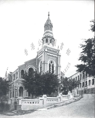
The Roman Catholic Cathedral on Wellington Street:

And the Hong Kong Club at the junction of Queen's Road and Wyndham Street:

Q16. Have you seen any photographs showing brothels in this area? They weren't famous like the buildings shown above, but they're an important part of the local history. I've seen photos of the 20th-century brothels in Shek Tong Tsui and Wanchai, but nothing from around here.
Photos - street scenes
The photos from the Peak give a broad view of the area, and the close-ups of buildings show what they were like, but where are the people? Street scenes will help show us the people who lived and worked around the CPS.
We get plenty of choice for Queen's Road. It was the main business thoroughfare, and well photographed over the years. Here's a view from c.1890, looking west from the junction with D'Aguilar Street:

A few of the streets leading up from Queen's Road were also popular with photographers, ie Wyndham Street for its flowers:

And Pottinger Street for its steps:

Wellington Street was another popular choice, I guess to show a "bustling Chinese street" scene for tourists. Here's a view from the 1880s, with the Roman Catholic Cathedral visible in the distance:

But for many of the other streets in the area, I've only seen one or two pre-WW2 photographs, eg
The view of Old Bailey Street in 1862 we saw in the last update:

Another photo from the 1860s showing the view up nearby Cochrane Street:

And this view of Shelley Street, one street over from Old Bailey Street, one up from Cochrane Street:

(I'm surprised to see this photo doesn't look a whole lot different from the previous two, even though it was taken around 80 years later in 1945.)
Q.17 Have you seen any other good photos of the area at street-level?
Before photos - sketches, paintings and engravings
Finally, can we find any illustrations of this area from the earliest years of the colony? That was before photography was widely used, so I'm looking for sketches, paintings and engravings.
Here's an example from 1845, a sketch of the island drawn from the hills at the back of Kowloon:

It was drawn by Lieutenant T.B. Collinson of the Royal Engineers. He was in Hong Kong to survey the area and produce a map of the island, and fortunately for us he also included several panoramic sketches. Here is a closer look at the Central area of the shore:

Note that only Government Hill and the Gaol are labelled, reflecting their importance at the time. In later views from the harbour, most of the CPS is hidden by buildings in front of it. But here it stands out, and I hope it can also be seen in other sketches / paintings from that time.
For a closer view, we've previously noted this 1846 sketch by Murdoch Bruce, where the arrow points to the then-new Magistracy building:

Q.18 Do you know of any other old sketches or paintings that show the CPS and its neighborhood? There are several other sketches by Bruce that will be suitable. Do you know of any others?
The great variety in this area must have made policing it a real challenge.
I hope we can find more photos of the area and its inhabitants to bring them to life, so any leads gratefully received!
Regards, David
References:
- In this project I'm performing paid research to find photos, sketches, and other images that can illustrate the history of the Central Police Station site. Read more about the project in the Introduction, and see photos we've already found of the Police Station, the Magistracy, and the Prison.
- "A report for 1877 issued by the Inspector of Brothels on behalf of the Registrar General's Office lists both the registered and 'sly' houses for Chinese and European patrons in the entire colony. Brothels tended to be confined to certain districts on Hong Kong Island; the areas in which they were most numerous being those covered in this book. The addresses listed include Peel and Graham Streets, Lower Lascar Row, Lyndhurst Terrace, Hollywood Road, Wellington Street, Tai Ping Shan Street, Square Street, Wing On Lane, Elgin Street and Staunton Street amongst many others that are still very familiar." Elizabeth Sinn writing on page 265 of A Sense of Place: Hong Kong West of Pottinger Street.
- Quote from Adam Nebbs, who has written a book about the 1878 fire: http://gwulo.com/The-Great-Fire-of-Hong-Kong
Comments
Ethnic distribution in Central District
Daivd, thank you for this closer look into Central District. You can find a map showing the "Ethnic Distribution of Population in Central District and Premises occupied by Protected Women, 1872" (Rates and Collection Book 1872, HKPRO) in an article written by Rev. Carl T. Smith. His article "Protected Women in 19th-Century Hong Kong" is published in the book: "Women and Chinese Patriarchy", ed. by Jaschok & Miers, HKUPress 1994; pp 221-237. The map is on p228.
re: Ethnic distribution in Central District
Thanks Christoph, I hadn't seen that before. Luckily the map you mentioned is part of the preview in Google Books:
c.1930 View from The Peak
Thanks to Tony Clark for sending in the following photo. The CPS is visible on the left side of the photo, about two-fifths up from the bottom: