Current condition
Demolished / No longer exists
Date completed
(Day, Month, & Year are approximate.)
Date closed / demolished
(Day, Month, & Year are approximate.)
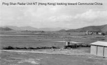
The RAF had a radar site here in the 1950s.
I've just put the marker roughly where Ping Shan is - if you know where the radar site was located please leave a comment below and I'll update the marker. [Update 2024 - the marker position should be accurate now, see comments below.]
I'm also interested to know the years the site was in use. (Current dates are our best guess based on comments below)
Soon after WW2 there was a plan to build a new airfield here (see http://gwulo.com/node/13265). I'm not sure if the Radar Station was built on part of the old airfield site or not, though it seems likely.
Regards, David
Photos that show this Place
1954
1954
1955
Comments
Some clues on years
Hi David,
While searching through the web I find some information that may give clues on the years the place was opeartive. That page is at:
http://www.forcesreunited.org.uk/namearchive/units/RAFNames/RAF-Ping-Sh…
It lists five people who were stationed there between 1950 to 1972.
breskvar
re: Some clues on years
Thanks Breskvar, I'll fill in those dates for now. If anyone can give a more accurate start / end date, please let us know.
Regards, David
Closing date
I've set the date the site closed to mid-1957, based on this message from Derry Martin:
I was looking back my diaries and the last time I did a duty at Ping Shan was on 23rd May 1957 and from then on it appears to have been secured by Chinese watchmen so I think it's fair to assume that the facility was being 'run down' from then on. When I visited Sek Kong in 1987, the C O of 28Sqdn. was greatly enlightened that Ping Shan had been a watching station and could then understand the role of the Vampire / Venom aircraft that patrolled the border with China and I think their role was to check on any activity that the radar unit picked up over the border. It was about that time that all the aircraft of 28 Sqdn was transferred to R A F Kai Tak and the closure of Sek Kong was implemented. I was moved from Sek Kong on the 1st of October 1957 on my was home for demob.
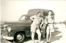
Thanks to Derry for also sending us a couple of related photos:
Location
I've updated the marker's location to what I think is the correct position on the map.
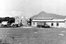
This photo shows there was an older two-storey building (A), and a newer shed- or warehouse-style building (B) on the site.
Both buildings are visible on this 1963 aerial photo of the area:
The open area, and I think building A, are also shown on the 1952 map: https://gwulo.com/node/12550?a=1#16~22.4442~114.0062~Map_by_GovHK-Marke…
RAF Ping Shan
Could this be the same place which later became Kong Shan. That also was a listening post and as a driver for Little Sai Wan we would have to pick up and deliver various communications.
re: RAF Ping Shan
There was an RAF Kong Wei very near here, but far enough away to be a different site.
If you look at the map linked below, RAF Kong Wei is the group of four markers at top left, and RAF Ping Shan is the single marker at bottom right:
https://gwulo.com/map-of-places#16~22.4457~113.9987~Map_by_GovHK-Marker…
Thanks
I knew it was Kong something but I guess my brain went back to army days when were stationed at Kong Shan (one of the Macintosh forts) up on the border. Thanks for clearing that up.