
What: Growth and decline, in equal measures.
The growth isn't hard to see - look at this photo taken by Fred Evans in 1959, shortly before he sailed home:
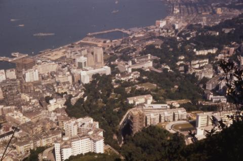
The three big bank buildings tower above everything else in Central. But just six years later, the 1965 photo shows them dwarfed by new, taller buildings including the Mandarin, the new Prince's Building, and the Hilton Hotel.
And there is plenty more building to come, with reclamation underway at several sites. Across the harbour, reclamation for Tsim Sha Tsui East is nearly complete. Back on the island, zoom in to the coastline at the left of the photo to see reclamation underway. It's where the General Post Office stands today. Then swing over to the right edge of the photo and a tongue of new land extends into the harbour off Wanchai. It's the start of the reclamation that will push the shoreline out from Gloucester Road out to today's Convention Avenue.
So where's the decline?
For that, take another look at last week's photo, taken around 1907. It also shows major reclamation and construction projects underway. In the foreground the British Military Hospital was just about finished. All the land from there to the sea belonged to the Army and Navy, with a large new Naval Dockyard under construction on freshly reclaimed land. Britain's Empire was reaching its peak.
Then look at Fred's 1959 photo. At first glance there seems to be little changed. But zoom in closely and you'll see that the dry-dock, centre-piece of the dockyard, is already half filled-in with earth and rubble.
Between the end of the second world and 1959, several British colonies had already gained independence. The Empire was shrinking, so the Royal Navy and its facilities were scaled back accordingly.
By 1965, the majority of the dockyard land had been sold back to the Hong Kong government, with only the Tidal basin kept for the Navy's use. Britain's Empire days were over.
Where: The photographer would have stood up at the Peak, probably along Lugard Road.
I'll post up some more detailed sections of this photo over the next few days, to give a closer look at a couple of areas.
When: I'm guessing early 1965 as the date. Prince's Building was completed in 1965, and here we can see it is just about finished. Then over in TST there's only a cleared patch of land where Star House will stand, but by the time this photo was taken in 1966, construction was already several storeys high:

Corrections welcome!
Regards, David
Reference: A107
Comments
Feb '65?
when I saw the picture on Flickr, it said Feb '65,
we moved into Luginsland in 1965, which is about a 2 story building site in the picture.
And they are building the tower over the lower peak tram (I think) which is dated to 1964, elsewhere on the site.
Now, If you could identify the Aircraft carrier in the harbour. It looks to be a US carrier of post WW2 vintage. (not an expert in this area) "should" be possible to date it to a few weeks.
Alun
The carrier, judging from the
The carrier, judging from the big "3D" radar scanner on the superstructure, is British, either Victorious or Eagle. Both were active in 1965. The big destroyer outboard on the Tamar jetty is a British County class, Wessex helicopter, and Seaslug missile launcher aft are visible. This class was in service from the early 1960s. These two ships were probably visiting from Singapore, where many RN ships were active in the 1960s, against Indonesian terrorism aimed at sabotaging Singapore's post-independence plans (This Indonesian activity was often referred to as "confrontasi").
St John's Building
You can also see St John's Building sited directly above the lower Peak Tram terminus is near completion and in scaffolding; we have a date of 1964 for that.
more here: https://gwulo.com/node/2536
I can comment a little bit on
I can comment a little bit on the 1965 photo. For perspective the road cutting across the middle of the photo is Garden Road. To the left we see the houses that used to sit atop Garden Terrace (much like Shiu Fai Terrace). There were five similar houses, each separated into three single story apartments plus one larger house at the bottom that I believe belonged to the owner of the property. The homes were demolished in the 80s (I believe) to make way for the current apartment blocks.
To the left of Garden Terrace are the Kam Yuen apartments - still there today. The rest of the buildings visible in that cluster seem to be gone now, replaced by larger apartment complexes similar to Garden Terrace.
In the bottom right the building with the t-shaped roof is I think Tavistock. I think it was built in the early 60s and at that time the largest apartments in Hong Kong at 4000 sq. ft. each. It still stands to this day but is now towered over by Tavistock II on the former site of its tennis court (plus every ounce of jungle between that and where Aigburth Hall used to sit).
Last thing worth mentioning are the bottom three tennis courts of the Ladies Recreation Club (LRC founded in 1883 by a group of British women that REALLY loved bridge or something). These are still there as are the small buildings to the right (part of the pumping station on Garden road? Not sure).
Also I recognise the building
Also I recognise the building on Kennedy road where the masons are headquartered is still there.
Does anyone know what the Hong Kong park land (going between Kennedy Road and Admiralty) was before it became "the park"?
Aircraft Carrier
Well spotted HO Lim-peng, It does seem to be one of the British ones you mentioned. I will look further into it.
Not Tavistock
Hi Chris, the T shaped buiding in front of Tregunter is Clovelly Court (1956),
Tavistock (1962) is to the right.
I don't remember Tavistock having a tennis court, there was a flat piece of grass to the right of it, down the steps, where we played football.I remember the Jungle well. Both Tregunter II and the new Aigberth Hall are in there.
The bottom 3 tennis courts are still there, because they sit on top of the service reservoir. (covered in about 1955-56).
Do you have any photographs of the area, that you can share with us?
middle road carpark
also to the right of Peninsula you can see the brand new Middle Road car park, still there today. Described in June 1964 Legco proceedings as near completion.
HMS Victorious No1 Buoy. Hong Kong Harbour (by day) Feb '65
I found the picture again
"HMS Victorious No1 Buoy. Hong Kong Harbour (by day) Feb '65"
trying to track down the days it was in HK.
HMS Eagle was there 23 feb to 11 Mar 65.
re: the Hong Kong Park land
Chris,
That area was the old Victoria Barracks. You can read more about the history of that area here.
Thanks for everyone's comments on this photo, they're very interesting.
Regards, David.
Unfortunately Marlowe I moved
Unfortunately Marlowe I moved to New York some years ago but my parents are still in Hong Kong. When I go back I'll take a look at our old photos.
Tavistock's tennis court wasn't in use by the time my friends and I turned the area into our personal clubhouse (early 90s). There was no net but you could see the lines were there. At least, that's how I remember it.
Interesting about the service
Interesting about the service reservoir Marlowe! Presumably the ground is too unstable to be suitable to large development? I used to take saturday morning tennis lessons with friends on those courts. There was an older building (I'd say 40s at the earliest) between the courts and the upper part of the LRC that seemed to house a few people. Any idea what that was / is?
What made the service reservoir no longer necessary and how did the LRC acquire the land?
Thanks!
Thanks David. Your site is a
Thanks David. Your site is a revelation.
Service Reservoir
Tthe service reservoir is still there, and has water in it ;-)
but it has a concrete roof, with tennis courts on it.
Look for pictures of the Albany filter beds (also known as the bowen road filter beds) to see how big it is.
Also, the Albany nullah still runs underneath it.
So I was smashing aces on top
So I was smashing aces on top of my water source?
Mind.
Blown.
on top of my water source?
only if you lived below bowen road,
there are service reservoirs on old peak road (behind #18)
behind chater hall,
I think there's one behind Island School. (off magazine gap)
Ships around Tamar
By email from Stephen Davies:
The carrier out in the harbour is HMS Victorious (her very distinctive
'searchlight' radar is diagnostic), there's a County class DLG alongside
the mole, inside the mole is a fleet oiler and a fleet support vessel
alongside the north wall. There's also a destroyer or other escort ship (rather WW2 profile) on the south wall of the basin.
Victorious was in the Far East Fleet (based in S'pore) from the late 50s
to when she was decommissioned in 1967/68. My hunch is that this is
Victorious and her squadron during the third commission. She was in HK in 1963 on her 2nd commission, but the squadron vessels were different, so I'd go for the third commission and working on a mid-60s date, came up with 1965. That's confirmed with the identical photo on Flickr (http://www.flickr.com/photos/61784330@N00/217965651/), when the ship was here in February.
HMS London will be the DLG, since she was here in 1965 also.
Not sure about the RFAs - that would need a bit more work. In theory they should be any of Reliant, Resurgent and Tidespring. The ship alongside the North Wall is almost certainly the Reliant. The oiler I'm not sure about but I suspect it may be American!
The destroyer on the South Wall of the basic is probably HMS Caesar who ended her long and distinguished career in HK in 1966.
I'm not very knowledgeable on naval terms, so I went back to ask for explanation of a couple of terms, which Stephen kindly provided:
it got to be a shorthand term)
Garden Terrace - more here
Garden Terrace - more here https://gwulo.com/node/5964
YWCA and St. John's Ambulance
YWCA and St. John's Ambulance can be added to Places in this photo.
I have done a little
I have done a little research, and it is likely that these ships were all RN participants in Exercise Sea Horse, a SEATO exercise that took place in Asian waters around May/June 1965. I would therefore, in view of the information I have seen on that exercise, assess their identities as follows:
DLG - London
Carrier-Victorious
Oiler - Tidereach
North Wall - Reliant
South Wall- Battle class radar picket destroyer Agincourt (it is definitely not Caesar )
On the east wall is a Ton class minehunter of the HK Squadron of that era
Just astern of Agincourt is possibly an inshore minesweeper of the HKRNVR
DLG (Destroyer Leader - Guided Missile) was a borrowed American classification, I believe only used for the County Class in the RN.
1965
Thanks for the Agincourt. I should have spotted that big 965 on the foremast. Battleships and Cruisers has a good image of Agincourt and Barossa in their radar picket guise in lay-up.
I was a middie in Tiger in 1964 in company with London and certainly we referred to her as a DLG. I note from the Glamorgan's commission book that the RN constructors referred to the type as DLGs.
Not sure about Tidereach. There's no whopping forward accommodation and bridge, and the derrick arrangement is wrong as are the aft superstructure and funnel. Further, I think there's fair evidence the photo was Feb 1965 and Seahorse was later in the year in May.
One possibility is Gold Ranger, which was certainly around at the time and, like all the Ranger class, had that very long after superstructure and a single long tank deck without a forward deckhouse.
SD
SHIPS AT TAMAR 1965
I also once served on a DLG (FIFE), my point was only that its use in the RN was, as far as I know, restricted to the Counties-GMD seems to be used for guided missile destroyers nowadays.
Ref the oiler, I gave consideration to the Australian SUPPLY (formerly TIDE AUSTAL), although I note the apparent lack of the characteristic RAN large pennant number forward. What do you think?
Ships at TAMAR 1965
Stephen,
I will go with you on "Gold Ranger" The profile fits well, particularly the lack of forward superstructure, and she was in Asian waters for many years, including 1965. She was scrapped in HK 1977, incidentally.
best regards
HO Lim-peng
i have a question but i dont
i have a question but i dont know if its a dumb one. in older pictures of hong kong idland all the trees and bushes between mid levels up to the peak are all really young and very short. in recent times all these trees and buches are heavily over grown and incredibly dense. my question is why the sudden growth spurt and how come 50 years ago there was virtually nothing there?
thanks
Firewood
Before the war, trees and grass were cut for firewood.
If you look at old pictures, you will see a lot of paths through the hills.
Of course, in 1841, it was "a barren rock, with nary a tree on it".
Trees
Over the history of Hong Kong there have been periodic "harvesting" of the trees. It started at least a few centuries ago when people from Guangdong stripped it bare and sold the wood. Clear cutting leaving no protection from the heavy rains, strips away the soil, and so it makes it impossible for the forest to grow back naturally.
When the British arrived, they began a re-forestation program that continues to this day.
Most of the Hong Kong vegetation was cut for fuel during the Japanese Occupation between 1942 and 1945.
With each subsequent wave of refugees, they used the plants and small trees for cooking.
Clearance for cultivation, cutting for firewood and charcoal, and hill fires were believed to be the main cause of deforestation in Hong Kong. Today, it is just hill fires.