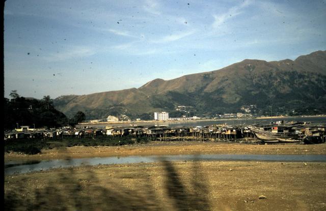
This is Tai Po. The small clump on the left is Yuen Chau Tsai (where Island House is) and the village infront was the hoklo boat people who have since all been moved to Kwong Fuk Estate.
I recognise the ridgeline in the background as I see it almost everyday. That ridgeline now forms part of the Wilson Trail as you go uphill from Tai Po Tauh. You may not believe it but that whole wet area in the middle has been reclaimed and now full of various high-rise estates.
In fact I would hazard a guess and say that your grandparents took this from the KCR train.
Wow, thanks so much, Phil! I never would have guessed Tai Po because I didn't know there had been a river out that way. I lived at CU for three years and often frequented the dai pai dong in Tai Po that I now hear is enclosed and a permanent structure. My grandparents did take the KCR out to Sheung Shui, so your guess that they took this photo from the train is correct! Thank you again!
Hi Susan - it's a great photo. Many thanks for sharing, I am always interested in seeing old pics of Tai Po. Actually the main body of water you can see is just the westernmost part of Tolo Harbour - so it is the sea, albeit an inlet.
Thanks very much for uploading these lovely photos. If you have any more to share, I recommend you also fill in the date, and once you've got the hang of that also add any Places if you know them. It makes it easier for future visitors to find them - we've got over 4,000 photos now, so otherwise they tend to get lost.
I don't think I've seen them before this photo. There was a typhoon (1960s I think) that caused a huge tidal surge in this area. A lot of people living in the stilt houses were killed.
Looking at this photo it's not hard to imagine why - but I was surprised to see they'd all been rebuilt again after the tragedy.
Thanks, David. It's been awhile since I've been on the site, so I'll make sure I identify the photos properly. Thanks so much for letting me post them here! I just love these old pictures and never cease to be amazed by how much HK has changed over the decades.
Actually, after looking at an aerial photo book last night (provided by T), I now realise that the tuft of greenery on the left isn't Yuen Chau Tsai but actually further towards the town - it's a mound of land that houses the Old Police Bungalow (now the Norwegian Int. Kindergarten). The hoklo village was situated around a causeway built that supported Kwong Fuk Rd, between there and Yuen Chau Tsai.
The road stays more or less on the same line it used to be on, as does the railtrack, but the sandy area you can see now houses an astro turf football pitch :-)
I had the recent pleasure of talking to a notable local historian (Dr Pat Hase of the Royal Asiatic Society) - he has been in the area since 1972 and remembers this community well, mainly because it was rather stinky.
Kwong Fuk Road, which is actually behind the 'village', ran across this part of Tai Po on a causeway and the huts were on either side of the road.
If you look closely at the left side hill you can actually see part of the bungalow I mentioned (now used by N.I.S).
Comments
Tai Po
Susan
This is Tai Po. The small clump on the left is Yuen Chau Tsai (where Island House is) and the village infront was the hoklo boat people who have since all been moved to Kwong Fuk Estate.
I recognise the ridgeline in the background as I see it almost everyday. That ridgeline now forms part of the Wilson Trail as you go uphill from Tai Po Tauh. You may not believe it but that whole wet area in the middle has been reclaimed and now full of various high-rise estates.
In fact I would hazard a guess and say that your grandparents took this from the KCR train.
Cheers, Phil
Tai Po
Wow, thanks so much, Phil! I never would have guessed Tai Po because I didn't know there had been a river out that way. I lived at CU for three years and often frequented the dai pai dong in Tai Po that I now hear is enclosed and a permanent structure. My grandparents did take the KCR out to Sheung Shui, so your guess that they took this photo from the train is correct! Thank you again!
Tai Po
Hi Susan - it's a great photo. Many thanks for sharing, I am always interested in seeing old pics of Tai Po. Actually the main body of water you can see is just the westernmost part of Tolo Harbour - so it is the sea, albeit an inlet.
Cheers, Phil
Tai Po, 1974
Oh, it's my pleasure to post these photos! I still can't get over how much Tai Po had changed in less than 20 years after this photo was taken.
re: Tai Po 1974
Hi Susan,
Thanks very much for uploading these lovely photos. If you have any more to share, I recommend you also fill in the date, and once you've got the hang of that also add any Places if you know them. It makes it easier for future visitors to find them - we've got over 4,000 photos now, so otherwise they tend to get lost.
There are general instructions for adding photos here, and extra information about adding Places here. Let me know if you need any help.
Regards, David
Stilt houses at Tai Po
I don't think I've seen them before this photo. There was a typhoon (1960s I think) that caused a huge tidal surge in this area. A lot of people living in the stilt houses were killed.
Looking at this photo it's not hard to imagine why - but I was surprised to see they'd all been rebuilt again after the tragedy.
Regards, David
Tai Po Hoklo Community
There is a whole bunch of photos taken by Nick Dewolf on FLICKR of the same community.
Here's one that helped me identify them (as you'll see from my comment on it).
http://www.flickr.com/photos/dboo/524237919/in/faves-31063481@N03/
Tai Po, 1974
Thanks, David. It's been awhile since I've been on the site, so I'll make sure I identify the photos properly. Thanks so much for letting me post them here! I just love these old pictures and never cease to be amazed by how much HK has changed over the decades.
Tai Po Hoklo Community
Actually, after looking at an aerial photo book last night (provided by T), I now realise that the tuft of greenery on the left isn't Yuen Chau Tsai but actually further towards the town - it's a mound of land that houses the Old Police Bungalow (now the Norwegian Int. Kindergarten). The hoklo village was situated around a causeway built that supported Kwong Fuk Rd, between there and Yuen Chau Tsai.
The road stays more or less on the same line it used to be on, as does the railtrack, but the sandy area you can see now houses an astro turf football pitch :-)
Tai Po Hoklo Community
Thanks, Phil!
Tai Po Hoklo Community
I had the recent pleasure of talking to a notable local historian (Dr Pat Hase of the Royal Asiatic Society) - he has been in the area since 1972 and remembers this community well, mainly because it was rather stinky.
Kwong Fuk Road, which is actually behind the 'village', ran across this part of Tai Po on a causeway and the huts were on either side of the road.
If you look closely at the left side hill you can actually see part of the bungalow I mentioned (now used by N.I.S).