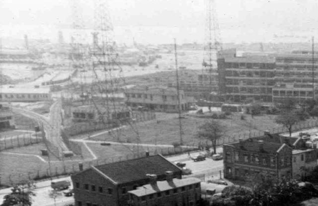
On the left of this image are railway tracks and a junction intruding into the Cable and Wireless tower compound. Has anyone knowledge of what these tracks were for? Reclamation works appears to be going on in the distance. Is the track going under Chatham Road or is it a dead-end?
Date picture taken
15 Jun 1960
Gallery
Shows place(s)
Comments
Railway at C&W station
If I zoom in it looks as though there's a buffer at the end of the rails, so it doesn't go under the road.
What was it used for? There's not much track this side of the points, so whatever used it must have been short.
Do you think the tracks linked up to the KCR?
Regards, David
Railway at C&W station
The only clue I can find is in the Mapping Hong Kong book page 149 that shows a track diverting off the main line near the Holt's Wharf area and approaches the C&W tower area. But this junction is not shown. The map notes that the Cross Harbour tunnel is under construction.
Railway at Cable & Wireless Site
Hi there,
I am looking at the 1964 Aerial Photo book page 54-55, which is showing the same area. But the building did not match. I began to wonder if the photo was taken much later than the aerial photo in the book.
My observations:
1. I presume the photographer of the photo above was standing atop the knoll close to the present day Oi Man Housing Estate. The taller building by the front of the Transmission Tower were there in the Aerial photos yet. Same as the dead-end railway.
2. I would like to point out, that particular track IS approximately on the present day location of the main East Rail. Remember, back in those days KCRC only run on a single track for two way traffic. Would that be the pre-cursor of it before the Terminus was moved to Hung Hom?
3. The old KCRC Track runs parallel to Chatham Road in TSTE, which went through some of the present day TSTE commercial buildings, History/Science Museums, PolyU campus and then under the road to the lifestock station, which fanned out with a direction from TST towards Homantin/Tokwawan.
4. After the Terminus was relocated to Hung Hom, it fanned out from the Mongkok and ran along Princess Margaret Road down there.
Remind me to bring the book again in our next gathering so you folks could browse through the pages yourselves.
Best Regards,
T
The short rail track there
I believe the short rail track there was for moving the dead people onto the train to transport back to inland China and Fan Ling Wo Hop Sek cemetry. I am not sure they are still doing that or not! In the 50's it had a place there for people to say farewell to the deads they called it Wing Beit Ting.
Between the Bus terminal and Gillies Rd. was the famous Tai Bao Mii. In the 40's there always found dead bodies laying on the shore, they were either murdered by people or executed by the Japanese soldiers.
Funeral homes were the main business in Gillies Rd then. I think that's why The World Funeral Home moved to there!
Railway Switchback Track near former Cable & Wireless Tower
If I have got my bearings correct, this short piece of railway line is what is called a "Switchback" ( a.k.a".zig zag") line or spur. Its function is for continuing along a track which suddenly heads roughly in the reverse direction. These switchbacks are usually associated with mountain railway lines where the train proceeds up the mountain in a series of "steps" instead of continually circling around the slope which makes construction far more expensive. A good example of this type of railway is to be found on Japan's Hakone -Tozan Line between Odawara and Gora.
However switchbacks are also used to gain access to railway depots, sidings etc.which lie parallel to the main tracks. This enables the locomotives ( not the whole train) to reach the facilities without travelling in long circular loop. During the late 1960s early 1970s the KCR was going through a whole series of changes and redevelopments,including locating its maintenance depot from Hung Hom to the Ho Tung Lau near Sha Tin as well as the relocation of the main terminus to Hung Hom on reclaimed land. This was all happening concurrently with the planning and construction of Hong Kong's first cross-harbour tunnel. During this construction phase a new smaller locomotive maintenance facility was constructed near Hung Hom and the purpose of this switch back was to provide access to new rail tracks (sidings). The Switchback seen in this picture is at my guess a temporary one built for this purpose until the new railway terminus at Hung Hom coud be completed . After the terminus was a completed a facility known as a rail transverser was installed ar the end of the tracks in the station. This facility enables locomotives to be moved sideways from one track to another and thus go around the passengers coaches to be recouped to the other end of a train for the return journey.
This railway history site contains an aerial photograph from 1969 (sixth image down) showing the "new loco shed" at Hung Hom with the switchback track and points (turnouts) highlighted in yellow . This seems to be near the former Cable & Wireless Tower.
That sounds like a lot of
That sounds like a lot of work for temporary tracks. Here is the full picture to give a better idea of the site location. I assume the circular structure in front is the old turntable:
JackW's suggestion of its…
kcr turntable
One can see the same tracks in this 1968 picture which also shows a turntable south of the Hunghom piers near the waterfront. There are also many tracks which seem going nowhere.
https://gwulo.com/media/42303
Those things must be somehow related to KCR. They were no longer in use in the 1960s.
https://zh.wikipedia.org/wiki/廣九鐵路
map
1960s map of the place show that the houses on the west side of Chatham road were quarters and workshops belonging to KCR. The building on the south side of the radio station was technical college, precursor of the polytechnic. Of course the houses at the radio station belonged to the radio station. As for the tracks there, a good guess would be they were for transportation during reclamation in the late 50s and early 60s.
mysterious tracks
This air view in 1969 shows the mysterious tracks and where they were going. One going to the turntable and a KCR building near the Hunghom piers. The other one going south.