Current condition
Demolished / No longer exists
E-mail from Alfred Wen:
I am looking for photos, plans or elevations of 14 Conduit Road prior to its demolition in the early 1970's. I understand it was built as the house for the French consul in the late 19th century. The reason for my interest is that my grandfather, Dr. Herbert To, raised his family there in the early 20th Century and I myself spent a year there in 1959-60. I remember it as particularly grand and hoping there may be a public record of the structure.
Any information would be much appreciated.
Today's #14 is called Emerald Court. I'm assuming that's the same place, but it may not be.
Alfred, if you can tell us the lot number (see this map), or the name of the building, that might help.
Regards, David
Photos that show this Place
1922
1922
1931
Comments
Victoria Lodge ?
Victoria Lodge on Old Peak Road was the residence of the French Consul General - built in about 1898.
http://gwulo.com/node/4935
re: 14 conduit road
Emerald Court is a rather humble block of 16 units completed in April 1966 according to Centadata - you can see it here:
http://maps.google.co.uk/maps?f=q&source=s_q&hl=en&geocode=&q=HONG+KONG…
its predecessor can most likely be seen here, perhaps the one at the furthest back with the very white Jamia Mosque directly in front. Marble Hall is on far right: http://gwulo.com/node/4802
Victoria Lodge
I have just read that the French Consul didn't move into Victoria Lodge until 1908, so the fellow could be right.
Paul Chater owned the building from 1895, until it was sold to the French.
Alun.
14 conduit road
Thank you for the information. Is the building labeled "1887" in the 1958 photo, Victoria Lodge?
Lot 1093 was Victoria Lodge
Lot 1093 was Victoria Lodge
Here is a 1901 map with the
Here is a 1901 map with the house names. You can compare the current 14 Conduit Road to this map.
Richmond House may be one candidate. It stretched from Robinson to Conduit Road.
1908 - Mr. Li Po Yung (known also as Li Tsz Ming), Richmond House, Robinson Road
(see http://www.archive.org/stream/twentiethcentury00wriguoft#page/186/mode/… )
Can you tell us if your grandfather owned, rented or worked in the house, or any other details of other house occupants to help us identifiy it ?
14 Conduit Road
Annelisec,
In response to your query of 10-28.
He owned the house from the 1920's until the 1960's. It would have been linked him, Herbert To, or the previous owner. He had a sizeable household of 8 children with associated domestic help where he entertained large gatherings of family and friends. After he passed away in the late 1960's it was demolished and the property developed by Stanley Ho and Willam To into the condominium that is on that site today.
Thank you for your efforts to find some documentation or photos.
Alfred Wen
I've decided that the house
I've decided that the house was above the one on the 1901 map named "Benfica" at 5 Robinson Road.
I found this in The life and times of Sir Kai Ho Kai
[One of Ho Kai's daughters], Sit-tit, married Dr. Herbert To, a dentist in Hong Kong.
Is this the same Dr. Herbert To?
14 Conduit Road
annelisec,
Yes, those are the people. I have the Life and Times book, but I did not find a reference to "Benfica" or 5 Robinson Road in the index.
Will these references lead to better sources of photos or plans for the house in question?
Thank you
We know the location, so next
We know the location, so next we can try and find the lot number and search on that to see if anything pops up.
If they owned it in the 1920s, I'm guessing that the lot was either subdivided, or the part above Benfica was not sold until after the 1901 map.
Unless there were major remodels in the 1950s, I don't think the (not online) Buildings Department would have anything.
Any chance you could sketch a map from memory of any features that you remember ? Perhaps that would twig the memory of someone visiting Gwulo.
I have forwarded the 1901 map
I have forwarded the 1901 map and the house names to a relative who lived in the house to see if he can confirm it by name or identify the footprint on the map.
I will try to draw a floor plan from memory and have asked the relative to share his recollection of the room layout with me.
The buildings between Robinson and Conduit on the 1901 map appear to be set back quite a distance from what I assume is Conduit Road. Did the house for the French consul exist at the time of the 1901 map?
I remember the front of the house on the Conduit Road property line with a large terrace behind the building overlooking Robinson.
Thank you again.
The Lands Department in North
The Lands Department in North Point has a set of maps from 1922. If you buy me lunch (HK$100) I'll go down and see what that lot looked like then and let you know what I find.
14 Conduit Road
Alfred, if your relative can remember the name of the old building, that will be a great help.
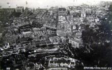
If you can remember the shape of the building, there's a small chance it's visible in this photo. The very bottom section shows some of the area we're talking about (you can zoom in to get a closer look).
Regards, David
I examined the photo and
I examined the photo and suspect that the house in obsured by the trees in the foreground. I also could not make out the terraces that overlook Robinson Road.
I have not heard from the relative confirming Benfica.
Is Benfica also the former Victoria Lodge and former French counsel's residence?
I am not sure if I confirmed an early post that the current Emerald Court built in 1966 at the current #14 is probably the site.
I also have some old newspaper clippings from the 1950's describing the house that I can email to you. Apparently there was a major renovation when it was purchased in the mid-1920's. The article also references the former French counsel having built it 70 years ago which would have been in the mid 1880's (my guess based on the undated article).
I hope this helps.
As for annelisec's lunch offer, I would be happy to oblige, but from NY?
Thank you for your continued help and patience.
Alfred
Paypal
Hi,
I was thinking of Paypal. I can send you a photo of the lunch, which seems to be something a lot of Hong Kong people do these days :)
If you can tell us the name of the newspaper and the date of the clippings, we might be able to find it online, and if there are from the South China Morning Post, we can definitely find it in the Public Library here.
I like Gwulo because every day is like an Easter Egg hunt.
14 Conduit Road
I've attached Alfred's clippings above.
I ran a few searches in the online newspapers, but didn't find anything useful:
If the original building dates back to the 1880s, it should have had a Robinson Road address initially, as Conduit Road wasn't built at that time.
Regards, David
"Sylvia da Costa-Roque" is
"Sylvia da Costa-Roque" is the author of the article. There is a journalist in Australia by that name.
I'll go hunting for the lot number of 14 Conduit Road at the Lands Department, and we shall see what we find.
Compare 1901 to now. Thanks
Compare 1901 to now. Thanks to tngan for the instructions to the 1:1000 Government map at https://www1.hkmapservice.gov.hk/DDS/
That clearly looks like the
That clearly looks like the plot. Perhaps the original building did not back onto Robinson (as I imagined) and relied on that flight of steps to reach the kitchen area under the former terrace.
In any event, is it likely there is any publicly available information on the former house - plans especially - or have we exhausted the leads?
I really appreciate your and David's efforts.
As for your lunch...I have used PayPal, so infrequently, I have to familiarize myself with it again. Where do I send your lunch tab?
David has identified the lot
David has identified the lot as 712.
I bought a copy of the original lease details online from the Government Land Search for HK$25.
The lease, for 999 years, started in 1861. The lot was subdivided in 1900, and 14 Conduit Road appears to be Section "D". Another HK$25 for Section D, and I got this info:
In 1962, the two owners were William To and Metro Realty Co. And the US connection ?
"Incorporated by Stanley Ho, Hong Kong Metro Realty Company, Inc. is located at 4610 University Ave Ste 1018 Madison, WI 53705.
Hong Kong Metro Realty Company, Inc. was incorporated on Monday, May 04, 1981 in the State of CA and is currently active."
Wisconsin ??? Is this really the Macau Stanley Ho ?? :)
The GeoInfo map (www.map.gov.hk) shows the following lots (select "lot" and enter IL and 712 - and if you click on them, it will show you the location on the map:
IL 712 RP
IL 712 S.A RP
IL 712 S.B RP
IL 712 S.B ss.1
IL 712 S.C
IL 712 S.D
the Lands Department search shows these - I only bought the "*" ones below - but if you want you can go buy them all and see which ones your grandfather had control over for 14 Conduit Road.
*INLAND LOT NO. 712
SECTION A OF INLAND LOT NO. 712
SECTION B OF INLAND LOT NO. 712
SECTION C OF INLAND LOT NO. 712
*SECTION D OF INLAND LOT NO. 712
SECTION E OF INLAND LOT NO. 712
SUB-SECTION 1 OF SECTION A OF INLAND LOT NO. 712
SUB-SECTION 1 OF SECTION B OF INLAND LOT NO. 712
THE REMAINING PORTION OF INLAND LOT NO. 712
THE REMAINING PORTION OF SECTION A OF INLAND LOT NO. 712
THE REMAINING PORTION OF SECTION B OF INLAND LOT NO. 712
So tomorrow I go to the Lands Office and see what is on the Public Works Department Map - if anything.
Based on what I find, you may decide to upgrade me to a fancier restaurant ;)
On the Public Records Office site there are two references to IL 712 - one is a Japanese title deed for the parts on Robinson Road, the other is one of the index cards from the Carl Smith Collection - but you have to go in to look at it.
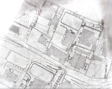
1922 map
Success. The 1922 Public Works Department Map shows the house. I've ordered a copy HK$45 - but here is a VERY rough sketch while we wait for the real thing. Lot 712 was divided about in half, leaving Benfica on the Robinson Road side. A single semi-detached house - meaning there was a common wall down the middle of the building - was built on the Conduit Road side.
The French Consuls' residence on Old Peak Road was also built this way. I have not found any other French connection.
So, you'll have to tell us if your grandfather had the entire house, or just the one half.
The actual map will be ready for pick up in about 4 days. If you want me to get the lease information for you on the other parts of lot 712, HK$25 each, I can do that.
Please send David an email and he will forward my email to you.
Costs so far:
$25 - Lot 712
$25 - Lot 712 Sec D
$30 - bus/MTR fare
$45 - map printing fee
Total: HK$120 - and you decide how much for lunch :)
Terrific! Will there be a
Terrific!
Will there be a floor plan(s) or just the footprint on the lot? Does the Public Works Department also have photos?
I don't know if he purchased both the Conduit Road and Robinson Road halves. I remember that exiting from the rear of the house below the terrace lead to Robinson. However, it could have been via that stepped path I saw on one of the earlier maps you sent. In any event, I am more interested in the Conduit Road half.
I will email David to get your email. It there is a delay, it is because I do not check the site everyday.
Thank you for pursuing this with slim leads. It is much appreciated. I hope it produces some useful images - plans, photos or both - of the house.
14 Conduit Road
Alfred, I expect the map will give us a good outline of the building, but no floor plan of the interior.
You wrote "I don't know if he purchased both the Conduit Road and Robinson Road halves." I think Annelise is saying there were actually three buildings on this rectangle of land between Robinson Road and Conduit Road:
Here things get a bit interesting, as from the newspaper article it appeared that Dr To bought and re-developed a single large house, that was originally built in the 19th century. That doesn't match the semi-detached house built in the early 20th century. It will also be interesting to see the clear view of the 1922 map, as both you and the article mention the building was right next to Conduit Road, without any garden between them.
Anellise's research shows that the lot was owned by William To and Stanley Ho as you described, but they already owned it when Dr Herbert To was still alive.
So we've got a fiew pieces of the puzzle that don't quite match up yet.
Regards, David
PS I've just emailed you and Annelise to put you both in touch.
14 Conduit Road
Recent updates give possible answers to my questions above.
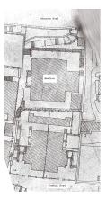
Here's the 1922 map of the area that Annelise found:
Then 80skid spotted the building on this 1930's photo, and Annelise cropped the relevant section to give this:
So putting those two together, I got this, where the red marks the building's outline in 1922, and the green shows extensions that had been added by 1930:
Then it all fits the article more closely. There was an older building (though built in the early-20th Century, not in the 19th C.), which the To family bought and redeveloped. Presumably they knocked the two semi-detached parts into one, and added the two extensions. The lower-right extension shown above would have fronted on to Conduit Road, matching the descriptions of walking straight off the street into the hall.
I'm still not sure where the French Consul fits into the story. Maybe they don't!
Great detective work! Would
Great detective work! Would there be any record of the late 1920's alteration with the Buildings Department? Old drawings or microfilm? I know Annelise offered to check there for another lunch, which I am happy to do, but I don't want to frustrate anyone if you think it will be a dead end.
Are there are any street views from the period? Did the property show up in 1954 or 1958 panoramas looking at Midlevels that you posted at the beginning of our search? I could not find it.
Thank you again for your interest and persistence on my behalf.
If you are buying lunch, then
If you are buying lunch, then I have an hour today to check it out ;)
I received more information
I received more information about the house from relatives who were also interested it getting photos and plans. I was off by a decade as to its acquisition - it was 1934. Immediately thereafter the existing building was rebuilt over a two year period and finally occupied in 1936. They guess the property was 75' x 100' or 150'. The property was only the portion numbered 14. No. 12 was owned by the Ho family.
I suspect that this would not change any of the sources of information that you or your volunteers have offered to date. But if there are other photos of that area from the late 1930's through the 1950's that have not been posted, I would appreciate posts or links inorder to continue my search.
We are using the 1922 map that Annelise located - thank her - to scale the remembered building plan onto the No. 14 side of the plot.
No. 29 was its address from the Robinson Road side if that is of any use in locating additional information.
Thanks.
Alfred
Alfred, 1906
I've spotted 14 Conduit Road in the newly posted 1906 photo. (see http://gwulo.com/node/7564#comment-15286)
Not your era, but it is interesting.
re: I received more information
Alfred, thanks for the extra information. Do you have any idea what the re-building involved? If it took two years it sounds like a major project. I wonder how much of the original layout survived?
I've found a possible source of floorplans - details here. Please keep us updated as you find more.
Regards, David
PS If you would like to give us some help in return, help with the Jurors List project is always very welcome.
Thank you for the
Thank you for the Architectural Services Department lead. I've emailed them and am waiting to hear back.
From what I have learned from relatives who lived in the house longer than me, it was a total redo in 1934-36 turning a traditional house into an Art Deco structure. I was given a facade drawing and some very schematic plans. However, I need to adjust the plans to the dimensions of the lot which I cannot find.
I went to the geomap site which has a measuring tool, but that gave me numbers very different from other's recollections. Are there lot dimensions listed somewhere for IL 712 S.D?
You and your volunteers provide wonderful resources. I would be happy to help with the jurors list but probably after the New Year when I have a block of time to figure it out.
Thanks.
Your dates may be off because
Your dates may be off because the relevant lots were origianlly mortgaged to Herbert To in 1926.
The top half of Lot 712 on the mountain side, was subdivided into B, C & D. Lot B was further subdivided in half.
14 Conduit Road is section D plus the dotted portion of B marked on this map.
Interesting...any way to get
Interesting...any way to get the lot dimensions of the D and B portions of 712? Were they on any of the documents that you retrieved?
BTW, the Architectural Services Department lead that David provided only has records of buildings on government land. They referred me to the Buildings Department where I remember you had already checked to no avail.
A house on 999 year leased land doesn't qualify as a building on government land according to them.
Copies of all leases are
Copies of all leases are available at the Lands Department for a fee. You have to go in person. Lunch again ?
While I appreciate your
While I appreciate your offer, it may not be necessary since you got copies of IL 712 and IL 712 S.D for the earlier lunch. Could you just email or post the information that are on the leases? I just need one dimension to work from with the 1922 map.
Thanks.
Anyone know of any other way
The scale on the 1922 map is 100 units (feet I'm guessing). If you can make out the box on the map, you can extrapolate. Anyone know of any other way to get lot dimensions except from the lease ?
What I sent earlier was the information that is available online. If you want full copies of the leases, with all the details, you (or someone you know) has to go down in person and order them. I think the fee is about HK$250 each. It is a copy of the actual lease, not just a summary of transactions (which is what I found online and have sent you).
I understand. Don't trouble
I understand. Don't trouble yourself any further for that level of detail at this point. But thank you for the offer. I am surprised lot dimensions are not online public information somewhere.
I will get some proximate dimensions based on the 1922 map and fit my schematic 1936 plans on the lot. Use that map as a guide, I am now told that the 1936 house was built out to the property lines on four sides and the rear terrace wall was built on the retaining wall separating the Conduit Road property from the Benfica house and property, so I have a very good start for my recreation of the floor plan.
Is there an online source of information to get the street elevations of 29 Robinson Road and 14 Conduit Road?
14 Conduit Road
Alfred,
The government's map site has a measuring tool. Google Earth does too.
For 'street elevations', do you mean their height above sea level, or a view of the building that's there today? For the view of the building, you can use the 'Streetview' feature in Google Maps.
Please let us know once you have the building reconstructed. I'm interested to see what it looked like at last.
regards, David
I will use the measuring tool
I will use the measuring tool on the map site. It is undoubtedly more accurate than people's memory.
Yes, I was referring to the street height above sea level for Robinson and Conduit in order to develop the cross section through the site.
I will post the drawings when I have them drawn.
Height above sea level
Unfortunately the online government maps I've seen don't show any contour lines in the built-up areas. Can anyone suggest another way to find the height?
14 conduit road
another more complete view of the site in 1931 here http://gwulo.com/node/7771
on eBay - Japanese
on eBay - Japanese Occupation. Can you find 14 Conduit Road extreme lower right ?
Re Japanese Occupation Photo
Actually the photo would be around 1927 to 1930. The King's Theatre on the corner of Wyndham St and QRC with its distinctive dome has not been built. See: http://gwulo.com/node/4705
The long flat top carrier in the harbour in the top centre looks like HMS Argus.
Re Japanese Occupation Photo
No sign of the China Building (1924) yet either, so that pushes it back a few years earlier.
Did they ever get drawn?
Did they ever get drawn?