Named after: The initials of the places at each end of the road, Tsuen Wan and Sek Kong. The new Route Twisk, shown in blue, was a much more direct connection than the old route, shown in red.

Timeline:
- 1950: In August, the British Army's Royal Engineers started work.
- 1953: The first traffic ran along the road in May. The road was only for military vehicles at this time.
- 1961: In May, the government took over responsibility for the road, and it was opened to civilian traffic. (Source in comments below)
Bryan Panter was in Hong Kong with the army in 1957-58, stationed at Sek Kong. He sent us this 1957 article from "Soldier" magazine:
ROUTE TWISK
The Army is always building new roads somewhere. Just now, the Royal Engineers are opening up new areas of Kenya and Malaya to wheeled vehicles, but the most spectacular of their recent achievements is in Hong Kong.
It consists of a short-cut across the New Territories, on the Asian mainland, to the prepared defences facing the Bamboo Curtain. Until Route Twisk was opened, the journey from Kowloon, in the south, involved detours by east or west round the main mass of hills. Either way the civilian roads are narrow, twisting, crowded and dangerous. In an emergency, they would put a brake on the Army’s defence effort.
Twisk, by cutting through the hills, as nearly as the contours permit in a straight line, is much quicker and safer. The journey from Tsun Wan, in the south, to Sek Kong at the northern end of Twisk is now one of only seven miles, against 23. It is, by the way, from the initials of these two places that Twisk gets its name, with the “i” thrown in to make a pronounceable word.


The new road is designed to carry the Army’s largest vehicles and guns, and its gradients are gentle, although it rises from sea-level to 1566 feet and descends to near sea-level again.
Work on the road began in August 1950 and the first traffic went through about May 1953, but the task is not yet completed. For another couple of years, Twisk will be “settling down,” a process which reveals flaws needing new work such as additional retaining walls. It is estimated that the total cost will be about six million Hong Kong dollars, or £375,000.
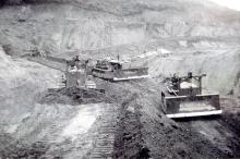
Royal Engineers did the “formation work,” altering the face of the earth by making cuttings and filling in depressions. Contractors then put in the drainage, foundations and surface.
For the Sappers it was a difficult task. The rock through which they had sometimes to blast a way was blue granite, some of the hardest rock in the world, and rock-crushers and other plant wore out at an alarming rate.
Twisk was one of the few new roads in Hong Kong which did not have to be diverted to avoid a Chinese grave, because the hills through which it passes are mainly uninhabited. At some places, however, jars containing the bones of somebody’s ancestors had to be moved, and compensation was paid.
Chinese belief in dragons was more troublesome. Villagers erect bamboo fences and gates to stop dragons damaging the crops. One of these gates was on a road over which lorries engaged on the project had to pass, and it delayed them. So the Royal Engineers, with the doubtful agreement of the villagers, dismantled it and set up in its place a steel drop-gate.
After a while, the villagers reported that the new gate kept the dragons out so well that their crops were better than ever before. The news got around and the gate became an object of envy to other villages—so much so that the Sappers had to keep a close watch on their stock of steel pipes of the kind used to make it.
The road-builders planned for Hong Kong’s sudden rainstorms when boulders four feet in diameter are swept along like pebbles. One stretch of the road is liable to be covered with three feet of water (which clears in ten minutes) and is made of solid concrete four-and-a-half feet thick.

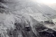
[The original author misinterpreted the photo above. As Gwulo contributor tngan notes, these channels are part of the catchwater system feeding water to the reservoirs.]
Maintenance, particularly in the settling-down period, is a heavy item in the Twisk budget. Chinese watchmen, all foremen engineers, patrol the road by night, more often in the wet season than in the dry. In the dry season they report damage due to shrinkage only about once in three months. In the wet season gangs are likely to be called out as often as once a fortnight.
There is a permanent maintenance gang of a foreman and 20 coolies in the dry season and a larger one in the wet season. In addition, the villagers of Cheong Long, who worked on the road when it was being built and remember that they were well paid by the Army, are willing to produce a coolie force of 60 (of both sexes), at a moment’s notice, day or night, for emergency repair work. The road has never been closed for longer than five hours.
Like any other mountain road, Twisk, with its curves and gradients, is potentially dangerous. So it has a speed limit of 30 miles an hour for vehicles of less than a ton load and 20 miles an hour for heavier vehicles. When cloud rests on the top of the pass, visibility is less than in London smog and most drivers, seeing the cloud from below, take the long way.
Twisk is a purely military road and is closed to almost all civilian vehicles. Service drivers ride merrily past the “No Entry” signs at each end of the road. It’s a fine feeling, they say.


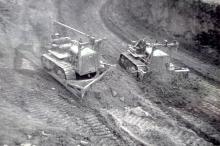
Ron Wallis was one of the Sappers performing the "formation work" described above. He sent in these photos of him at work on his D7 bulldozer:


Thanks to Bryan and Ron for sharing their photos with us.
Further reading:
- More of Bryan Panter's photos
- More of Ron Wallis's photos
- Sek Kong Army camp
- RAF Sek Kong.
- This page is an example of the new "Street" type of page. You can see more Streets on a map or in a list, and you're invited to add new Street pages to the Gwulo website.
Photos of this street:
Comments
I for Into
I believe the "I" comes from Tsuen Wan Into Sek Kong. At least that's what I heard.
twisk
Remember it well used to travel from LSW to Sekong over the twisk then return by coast road stopping at Dairy Farm for an icecream.
Seem to remember around 1953-55 time a Journalist was killed when vehicle went over the side it was quite a good road but a bit dodgy remember excellent view of Sekong and chinese border from the top.
Harry
twisk
great article
my late father did his military service in hong kong 52-54 stationed in sek kong when twisk was being built. he also subscribed to the view of the writer of the article that TWSK was impossible to say, so a vowel was thrown in for good measure to make it into a word recognisable, and indeed pronounceable,un by english speakers. i remember going up via tsuen wan in the late sixties, on the right hand side was a massive shanty town - from there i learned the cantonese word muk nguk or muk uk to describe those dwellings. fortunately things have moved on since :)
TWISK
I lived at 106 Sek Kong Village from 1986-1993, the first house as you come down the other side from Route Twisk into Sek Kong. These officer's houses (my father was one) were abandoned after we left, and still stand exactly the same as the day we moved out. I visited last month to find the door to my old house open, and ventured inside to find it as it was when we left. Our old bed frames are still there and a packet of my old air rifle pellets still sits on the windowsill!
There are four houses there, all unoccupied, with PLA officers having moved into the swankier houses just down the road across the small bailey bridge.
I was told then that TWISK was named after a Major Twisk, but having never come across this name since then, I think it more likely that the name comes from the two places it links - Tsuen Wan Into Sek Kong.
Twisk
My Father said that the "I" was for "intersection" rather than Into or Interconnect, but putting an "I" into it to make it pronouncable makes perfect sense.
I remember going out to Sek Kong to see Kart racing and an airshow in the early 70's. That's a great road as I remember it.
Route Twisk
I had to laugh here as for years I thought it was TWIST becos of all the bends- It was a fave ride with our biker boy friends.
Route Twisk
It's great hearing your stories of Twisk (& Twist!). I don't think I've ever been right along it, but I've done the first half from Tsuen Wan several times, catching the bus up to where the Maclehose Trail crosses the road.
The article says that originally the road was closed to civilians, which I didn't realise. Any memories of when it was opened up? It was probably a big deal at the time, but with all the extra highways and tunnels built since then it's a very quiet road these days.
twisk
when you reached the top of the twisk there was a t-junction where a road ascended right to the peak of tai mo shan and the army post there. that tranche was off limits. anyway you still had breathtaking rural views across the fields through those little villages and into china. there was a little car park and a pagoda at the side of the road so you could stop and take in the scenery
Route Twisk
Back in the 1950s, as far as I understand, Route TWISK was a military road constructed by the Royal Engineers to provide a quicker route between the foothills and the military facilities at Tai Mo Shan, Sek Kong and beyond.
To relieve pressure on the Castle Peak and Tai Po Roads, the Government negotiated with the mlitary authorities for the road to be opened up to civilian traffic. I recall reading about the opening but this did not happen until the 1960s.
twisk
In the 1950's the twisk was purely for military traffic no civilian vehivles were allowed
Route Twisk
I seem to have the feeling that the acronym stands for Tsuen Wan INTERCHANGE Sek Kong
Route Twisk
Shortly after I arrived in Hong Kong I was told that the Route Twisk was supposed to have been paved to a certain width thoughout its length. It was only after it was completed (and the contractor paid) that it was discovered to be one foot (?) narrower than the specification! Needless to say, the contractor was no longer available to answer any questions!
Route twist
I lived in army quarters from 1967 -1969 in Sek Kong.many times I visited the peak of Tao mo Shan, the views were breath taking. Have many happy memories of living here an driving down the many hairpin bends down into Kowloon
Route Twisk open to the public on 25 or 26 May 1961
This article contains some newspaper clippings (South China Morning Post & Sing Tao Daily News) which indicate that Route Twisk was open to the public on 25 or 26 May 1961 : --
https://web.archive.org/web/20090414135921/http://home.hkstar.com/~purity2/twisk/twisk.html
Bus service started on 24 June 1961 according to Wikipedia : --
https://en.wikipedia.org/wiki/KMB_Route_51
re: Route Twisk open to the public on 25 or 26 May 1961
Thanks for pinning down the date. I've updated the text above.