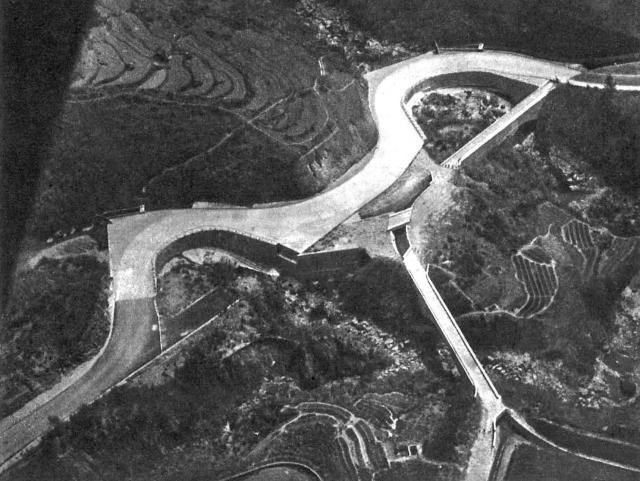
I don't believe that is a drainage system. Instead it is a catch water ferrying rain water from the western slopes towards reservoirs. I think I know where the photo was showing. It seemed to be where the catch water cross Route TWSK just a bit lower than the hair-pin turn. The catch water system is still in use today.
Thanks T. The same area is shown in another photo from that article:
Curving up into Asia - the start of the road from Tsun Wan, by Bryan Panter
I couldn't understand why they went to the trouble of building those "road bridges" in the lower photo, if they wouldn't be used. But it makes sense that they're part of the catchwater system instead.
The bridges are aqueducts, bringing water from catchments around the southern end of the Route 3 tunnel & above Sham Tseng to the Shing Mun Reservoir if I'm not mistaken.
The aqueducts are a bit narrow for vehicles, if this was a military road built as a result of concern given the overall geopolitical state-of-play at the time.
Note the water goes straight on from the downstream end of the downstream aqueduct, whilst the road is perpendicular. Leaves me with the impression that the two aren't all that related.
There's also several sets of three dark bits that might be bollards to prevent vehicles from crossing the aqueducts.
And there doesn't look to be much of anything to drive on once past the upstream end of the upstream aqueduct.
If the aqueducts were previously this section of Route TWISK, then they appear to have been a bit of a bottleneck. Granularity of maps & aerial photos over the years thwart proving or disproving that theory.
As originally built, it appears that water coming down from the NE ran over Route TWISK. If of sufficient volume, the opening between the two aqueducts might allow some of that water to go to Shing Mun.
What looks to be a runaway vehicle trap for vehicles descending from Chuen Lung is where there's a bridge now as that section of Route TWISK is now straight. You can see a notch on the other side where presumably that bridge would later land, suggesting it was where a bridge would go instead of a runaway vehicle trap.
Comments
Re: Catch water
Hi There,
I don't believe that is a drainage system. Instead it is a catch water ferrying rain water from the western slopes towards reservoirs. I think I know where the photo was showing. It seemed to be where the catch water cross Route TWSK just a bit lower than the hair-pin turn. The catch water system is still in use today.
T
Re: Catch water
Thanks T. The same area is shown in another photo from that article:
I couldn't understand why they went to the trouble of building those "road bridges" in the lower photo, if they wouldn't be used. But it makes sense that they're part of the catchwater system instead.
Tai Kiu Tsuen
This is the section of the road that passes Tai Kiu Tsuen and is not too far from the HK gun club.
Big Bridge or Big Water Road Village?
The bridges are aqueducts, bringing water from catchments around the southern end of the Route 3 tunnel & above Sham Tseng to the Shing Mun Reservoir if I'm not mistaken.
The aqueducts are a bit narrow for vehicles, if this was a military road built as a result of concern given the overall geopolitical state-of-play at the time.
Note the water goes straight on from the downstream end of the downstream aqueduct, whilst the road is perpendicular. Leaves me with the impression that the two aren't all that related.
There's also several sets of three dark bits that might be bollards to prevent vehicles from crossing the aqueducts.
And there doesn't look to be much of anything to drive on once past the upstream end of the upstream aqueduct.
If the aqueducts were previously this section of Route TWISK, then they appear to have been a bit of a bottleneck. Granularity of maps & aerial photos over the years thwart proving or disproving that theory.
As originally built, it appears that water coming down from the NE ran over Route TWISK. If of sufficient volume, the opening between the two aqueducts might allow some of that water to go to Shing Mun.
What looks to be a runaway vehicle trap for vehicles descending from Chuen Lung is where there's a bridge now as that section of Route TWISK is now straight. You can see a notch on the other side where presumably that bridge would later land, suggesting it was where a bridge would go instead of a runaway vehicle trap.
-kpl.