As Jason Wordie points out in Streets: Exploring Hong Kong Island, Glenealy the street was named after "a private house that once stood on the site of today's Roman Catholic Cathedral". Also see my recent 'Glenealy Location' post.
Thank you, Annesilec. You must be right. It was a large house and a garden occupying the stretch of land between Caine Road and Arbuthnot Road with a pavilion at the southernmost corner.
Not quite. The maps at Glenealy - 2 Caine Road show clearly that the Cathedral itself did not stretch as far as Caine Road. On the actual site which was occupied by the building Glenealy now stands a building housing the offices of the R.C.Bishop. In other words, the Cathedral was built before Glenealy was demolished.
Anon: Also worth considering is that when Constance Gordon-Cumming stayed at Glenealy, she described it thus:
To-day we have been sitting in the garden of this pleasant home, beneath the cool shade of large thick-leaved India-rubber trees . . . my present luxuriant quarters (which stand on a considerable elevation overlooking the harbour) having extensive private grounds almost adjoining the beautiful public gardens.
The point 'nearly adjoining the beautiful public garden' seemed to match the present day location of the compound of the Roman Catholic Cathedral/Caritas/Parish office/Catholic Diocese Centre.
Adam, you've reminded me that there is a painting by Gordon Constance-Cumming of the view from Glenealy looking east or north-east, bearing a number of signatures including that of Henry Lowcock. Must try and locate it.
After reading the paragraphs I believe the author had nailed the location in plain English alright. No doubt, it is the present day Catholic compound at Caine Road & Glenealy.
I think that we are all agreed that the building Glenealy was situated somewhere on what became the Catholic Cathedral and its compound. The question is whether it was in the northern part, facing Caine Road (No.2), or whether it was further to the east overlooking the Glenealy ravine. I am afraid the book does not answer this for us.
The book does suggest, though, that the Cathedral was at least built on part of Gleneal's 'extensive private grounds'. My large-scale 1850 map of Victoria shows a large single numbered lot at the corner of Caine Rd and Glenealy and I would expect that this lot remained the same when it was Glenealy and grounds and later sold by Gibb Livingstone for the Cathedral and grounds.
I think, Adam, that you are suggesting that Glenealy (the house) stood on the southwestern corner of the junction Caine Road and Glenealy (the path). If so, I believe you may be right. What is the lot number shown in your 1850 map?
From "Golden Guide to Hongkong and Macao" by P.H.M.Jones (published 1969 by Far Eastern Economic Review):
In the next year (1876?) Bishop Raimondi bought for St Joseph's a house on No.9 Caine Road, then called Buxley (sic) Lodge, and in 1880 an area in Glenealy - a term which then designated the district as far as Shelley Street - known as the Sassoon Estate between Caine Rd and what would shortly be Robinson Rd. There was a house on it which the Brothers moved into, and beside it a matshed school was erected in which they opened classes on June 6, 1881.
Have located the copy of Constance Gordon-Cumming's painting of the scene looking east from Glenealy. It was a Christmas card I received some years ago. Unfortunately, I have not been able to work out how to get the image onto a post. Will persevere.
The note at the back of the card includes the following names: S Burdon, Bishop/ D J Bur.../ John Henderson; P Esther Burdon; Annie Loftus Lowcock; H B Gibb; H Lowcock.
The names on the Christmas Card are mostly familiar...Bishop John (could it be a J not an S?) Burdon and his wife, Annie and Henry Lowcock (her hosts as already mentioned) and Hugh Bold Gibb of Gibb Livingstone. I look forward to seeing it.
That's great, thanks for posting it. I wonder if it was painted from the hill above Glenealy (the house) and those are its chimneys on the bottom right.
Unfortunately those 'Zoomify' pictures stop appearing/working on this computer after they've been looked at once. Until I restart anyway.
An interesting comment from Solomon Bard's "Voices from the Past":
"Glenealy one of the prettiest spots in Hongkong is to be given up to the ruthless hands of the builder...........The west side...is privately owned ground, and the owners have decided to utilise their property by building upon it. The ground has hitherto been kept in order by the Government, being planted with palms and ferns, and probably many may have been under the impression that it was Government land."(Hongkong Telegraph of 12th December 1898)"..
I just checked the original article and it says that the land was on 'the west side, between the United States Consulate and the pumping station.' I have a feeling that this area was at the top of Glenealy, close to Robinson Road, near what is shown on my 1887 map as Glenealy Tank, which may have been connected to the pumping station.
A map from the 1930s (3-5b, Mapping Hong Kong) shows a large buiilding labeled 'Glenealy' in the northern tip of this triangular plot. It's a different shape from the building on the 1901 map that Annelise provided, and looks about the right shape for the building behind the cathedral in this photo.
It appears we've got several generations of buildings named Glenealy to deal with.
Annelise, any idea what year the photo above was taken?
Yes, you're spot on David. I have just checked my copy of that map and there it is, albeit spelt Gleneally (probably just a spelling error by the cartographer). Surely a later generation Glenealy.
EDIT: Maybe not the same map as yours exactly. Mine is a cumbersome 5-sheet affair. 1936.
Although this is quite rude, I believe this question could prove of interest for many of the Hong Kong-enthusiasts on gwulo.com. Why was the old name of Glenealy Ravine changed? I believe it was named after Elliot - correct me if I'm wrong please, but do explain! Just a curious thought that crossed my mind.
You are right. It was originally called Elliot's Vale. With the presence of the house called Glenealy near today's Roman Catholic Cathedral, I suspect the access path to the house following the ravine became known in time after the name of the building. I suppose a glen sounds preetier than a ravine!
David, I incorrectly linked this photo to the house named Glenealy and the Glenealy neighborhood. Strangely, I'm not allowed to delete the connection. Can you help me? Thanks.
Comments
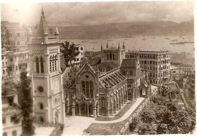
Roman Catholic Cathedral
Would the large building on the right of the photo, behind the Cathedral, be Glenealy then? Surely too big to be one family's home.
No, that building is on the
No, the Catholic Church bought the house named Glenealy and replaced it with this Adminstration Office building.
Glenealy gone by then.
As Jason Wordie points out in Streets: Exploring Hong Kong Island, Glenealy the street was named after "a private house that once stood on the site of today's Roman Catholic Cathedral". Also see my recent 'Glenealy Location' post.
regards ,
Adam
Roman Catholic Cathedral
Thank you, Annesilec. You must be right. It was a large house and a garden occupying the stretch of land between Caine Road and Arbuthnot Road with a pavilion at the southernmost corner.
Glenealy - 2 Caine Road
Gleanealy - PRO
http://www.grs.gov.hk/PRO/imgroot/pro-ref-103/r103_01_01.jpg
Glenealy gone by then
Not quite. The maps at Glenealy - 2 Caine Road show clearly that the Cathedral itself did not stretch as far as Caine Road. On the actual site which was occupied by the building Glenealy now stands a building housing the offices of the R.C.Bishop. In other words, the Cathedral was built before Glenealy was demolished.
I'm missing sopmething
I'm missing something here. Why do we think that Glenealy was at 2 Caine Rd?
I'm missing something
Quite right, Adam. I jumped to conclusions, because of the 1901 map. I think it's right, but I have no supporting evidence.
Re: What's left of Glenealy
Hi there,
So can we assume what's left of the Glenealy is the present day short street called Glenealy?
Best Regards,
T
Glenealy's gardens
Anon: Also worth considering is that when Constance Gordon-Cumming stayed at Glenealy, she described it thus:
To-day we have been sitting in the garden of this pleasant home, beneath the cool shade of large thick-leaved India-rubber trees . . . my present luxuriant quarters (which stand on a considerable elevation overlooking the harbour) having extensive private grounds almost adjoining the beautiful public gardens.
Re: Glenealy's Gardens
Hi there,
The point 'nearly adjoining the beautiful public garden' seemed to match the present day location of the compound of the Roman Catholic Cathedral/Caritas/Parish office/Catholic Diocese Centre.
Best Regards,
T
Glenealy's gardens
Adam, you've reminded me that there is a painting by Gordon Constance-Cumming of the view from Glenealy looking east or north-east, bearing a number of signatures including that of Henry Lowcock. Must try and locate it.
Painting
That's interesting. Would make a good addition to the second edition of The Great Fire of Hong Kong, if there is one.
Original book - writing from Glenealy
in eBook form, click below for the relevant pages:
http://www.archive.org/stream/wanderingsinchin00gord#page/18/mode/2up/search/Mrs+Lowcock
Re: Original book - writing from Glenealy
Hi there,
After reading the paragraphs I believe the author had nailed the location in plain English alright. No doubt, it is the present day Catholic compound at Caine Road & Glenealy.
Best Regards,
T
Original book - writing from Glenealy
I think that we are all agreed that the building Glenealy was situated somewhere on what became the Catholic Cathedral and its compound. The question is whether it was in the northern part, facing Caine Road (No.2), or whether it was further to the east overlooking the Glenealy ravine. I am afraid the book does not answer this for us.
The book does suggest,
The book does suggest, though, that the Cathedral was at least built on part of Gleneal's 'extensive private grounds'. My large-scale 1850 map of Victoria shows a large single numbered lot at the corner of Caine Rd and Glenealy and I would expect that this lot remained the same when it was Glenealy and grounds and later sold by Gibb Livingstone for the Cathedral and grounds.
The book does suggest
I think, Adam, that you are suggesting that Glenealy (the house) stood on the southwestern corner of the junction Caine Road and Glenealy (the path). If so, I believe you may be right. What is the lot number shown in your 1850 map?
From "Golden Guide to Hongkong and Macao" by P.H.M.Jones (published 1969 by Far Eastern Economic Review):
In the next year (1876?) Bishop Raimondi bought for St Joseph's a house on No.9 Caine Road, then called Buxley (sic) Lodge, and in 1880 an area in Glenealy - a term which then designated the district as far as Shelley Street - known as the Sassoon Estate between Caine Rd and what would shortly be Robinson Rd. There was a house on it which the Brothers moved into, and beside it a matshed school was erected in which they opened classes on June 6, 1881.
Painting
Have located the copy of Constance Gordon-Cumming's painting of the scene looking east from Glenealy. It was a Christmas card I received some years ago. Unfortunately, I have not been able to work out how to get the image onto a post. Will persevere.
The note at the back of the card includes the following names: S Burdon, Bishop/ D J Bur.../ John Henderson; P Esther Burdon; Annie Loftus Lowcock; H B Gibb; H Lowcock.
Lot and Painting
The lot number on my 1850 and 1887 maps is 59.
The names on the Christmas Card are mostly familiar...Bishop John (could it be a J not an S?) Burdon and his wife, Annie and Henry Lowcock (her hosts as already mentioned) and Hugh Bold Gibb of Gibb Livingstone. I look forward to seeing it.
Glenealy
Adam, please see the image at "Looking East From Glenealy".
Re: Image
That's great, thanks for posting it. I wonder if it was painted from the hill above Glenealy (the house) and those are its chimneys on the bottom right.
Unfortunately those 'Zoomify' pictures stop appearing/working on this computer after they've been looked at once. Until I restart anyway.
Glenealy
An interesting comment from Solomon Bard's "Voices from the Past":
"Glenealy one of the prettiest spots in Hongkong is to be given up to the ruthless hands of the builder...........The west side...is privately owned ground, and the owners have decided to utilise their property by building upon it. The ground has hitherto been kept in order by the Government, being planted with palms and ferns, and probably many may have been under the impression that it was Government land."(Hongkong Telegraph of 12th December 1898)"..
Re: Glenealy
I just checked the original article and it says that the land was on 'the west side, between the United States Consulate and the pumping station.' I have a feeling that this area was at the top of Glenealy, close to Robinson Road, near what is shown on my 1887 map as Glenealy Tank, which may have been connected to the pumping station.
re: Glenealy
A map from the 1930s (3-5b, Mapping Hong Kong) shows a large buiilding labeled 'Glenealy' in the northern tip of this triangular plot. It's a different shape from the building on the 1901 map that Annelise provided, and looks about the right shape for the building behind the cathedral in this photo.
It appears we've got several generations of buildings named Glenealy to deal with.
Annelise, any idea what year the photo above was taken?
More Glenealy
Yes, you're spot on David. I have just checked my copy of that map and there it is, albeit spelt Gleneally (probably just a spelling error by the cartographer). Surely a later generation Glenealy.
EDIT: Maybe not the same map as yours exactly. Mine is a cumbersome 5-sheet affair. 1936.
A Curious Question
Although this is quite rude, I believe this question could prove of interest for many of the Hong Kong-enthusiasts on gwulo.com. Why was the old name of Glenealy Ravine changed? I believe it was named after Elliot - correct me if I'm wrong please, but do explain! Just a curious thought that crossed my mind.
Re: Curious Question
You are right. It was originally called Elliot's Vale. With the presence of the house called Glenealy near today's Roman Catholic Cathedral, I suspect the access path to the house following the ravine became known in time after the name of the building. I suppose a glen sounds preetier than a ravine!
David, I'm incorrectly…
David, I incorrectly linked this photo to the house named Glenealy and the Glenealy neighborhood. Strangely, I'm not allowed to delete the connection. Can you help me? Thanks.
To delete a connection from…
To delete a connection from a photo you added, you should be able to: