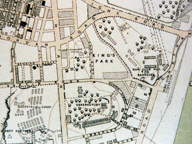
Unfortunately this map is not detailed enough solve the mystery of Cox's Path lower and upper, but what is interesting is that the grounds and building of Chater's Bungalow are well dilineated just south of Austin Rd. and spanned where Hillwood Road would later be placed. What a piece of real estate that musthave been!!
Are more detailed maps available of this area and era? I guess it would mean a visit to the archives.
If you zoom in to the maximum and move to the right, at the edge you should be able to see the Hung Hom Station marked closed to the present day History Museum.
Back then there were more train stations along the way.
80skid, any chance you can re-link that one? The link above has expired already (which leads to another question - how to make a permalink to something on the HK Library website?)
Comments
Cox's Path
Unfortunately this map is not detailed enough solve the mystery of Cox's Path lower and upper, but what is interesting is that the grounds and building of Chater's Bungalow are well dilineated just south of Austin Rd. and spanned where Hillwood Road would later be placed. What a piece of real estate that musthave been!!
Are more detailed maps available of this area and era? I guess it would mean a visit to the archives.
Re: KCRC former Hung Hom Station
Hi there,
If you zoom in to the maximum and move to the right, at the edge you should be able to see the Hung Hom Station marked closed to the present day History Museum.
Back then there were more train stations along the way.
Best Regards,
T
KCR Workshops, Hung Hom
Has anyone got photos of the KCR Workshops at Hung Hom from around mid fiftees or earlier?
re: 1924 map
HK library has a bigger version of the same map here, covering the whole of the peninsula:
http://hkclweb.hkpl.gov.hk/hkclr2/igateway?svc=ctcvr&hid=1&itemid=28&ss=ContentMap&litemid=760747&lsubj=&lcol=M000000D&lcat=M00000B5&llvl=-
re: 1924 map
80skid, any chance you can re-link that one? The link above has expired already (which leads to another question - how to make a permalink to something on the HK Library website?)
re:1924 map
http://hkclweb.hkpl.gov.hk/hkclr2/igateway?svc=ctcvr&hid=6&itemid=28&ss=ContentMap&litemid=760747&lsubj=&lcol=M000000D&lcat=M00000B5&llvl=
this should work - if it goes down again just search Kowloon with the maps box ticked
the snappy search link is: http://hkclweb.hkpl.gov.hk/hkclr2/internet/eng/html/sch-bas_srch-01.html