Current condition
Demolished / No longer exists
Date completed
Date closed / demolished
(Day, Month, & Year are approximate.)
was where William Pedder, the first Harbourmaster, had his office. It was above Wyndham Street.
his book Hong Kong Cavalcade, John Luff wrote: "Pedder built his office on the rocks above a track which has since become Wyndham Street, and for many years the site was known as Pedder's Hill. "The harbourmaster's boat was tied up at the end of a wharf which extended to the deep water. Pedder's Wharf became a definite locality, and, as the old records show, several firms used it as a mailing address."
http://www.thestandard.com.hk/news_detail.asp?pp_cat=&art_id=40111&sid=&con_type=1&d_str=19980813&sear_year=1998
Anyone know the exact spot, and when it was built over?
Later place(s) at this location


Comments
re: Harbour Master's House
The Mapping Hong Kong book to the rescue:
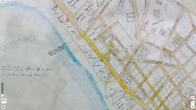
A c.1867 map from the HK Public library shows that piece of land had been divided into three lots. The text isn't very clear, but I think they are 615, 616, 617, numbered north-south. The map doesn't show whether the building is still there or not.
Back to Mapping Hong Kong, and Plate 3-2 (1889) shows an access lane (today's Mason Lane) between lots 617 and 616. There's no gap between lots 616 and 615, but you can see their boundary by projecting Stanley Street eastwards.
So that's the location fixed (I've updated the marker above). Can anyone confirm the date the building was demolished?
PS Thanks for starting this thread as a Place!
re: Harbour Master's House
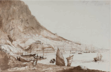
A couple of extra pieces of information. First an 1857 print from Brian Seed, which shows the hill and house in the top-left image:
Then this clipping from 1866 introduces the new Harbor Master's Office on the Praya West, open for business from 1st August. (If you're searching for more information, note that both spellings harbour / harbor are used).
So the original building may have been demolished some time between 1857 & 1866?
re: Harbour Master's House
There's an interesting very old granite wall that stretches all the way behind (south of) the buildings on On Lan Street, allowing the hill to be terraced. Not many other signs of what must have been one of the very first colonial buildings to be constructed
Re: On Hing Terrace 安慶臺
Hi there,
That stone wall is actually the foundations On Hing Terrace (安慶臺). There is still an engraving of 安慶臺 painted in gold on the New World Building side of it, right behind the demolition site of the shop house.
I really have no idea about how old is On Hing Terrace. Modern day On Hing Terrace is a commercial building sitting on the old foundation.
Best Regards,
T
Harbour Master
Ther first harbour master was Lieutenant William Pedder who held the position intil 1854 when he retired, being replaced by Captain R.W.Watkins R.N
His office was originally on board a ship, but no records exist to show this. in 1843 it appears that a room in Mr Pedders house built at his own expense on the hill named after him, was used as a harbour office. Later about 1845 a brick building was erected on the site of present City Hall and this was occupied by the harbour department until 1866. In that year a permanent building of brick and stone,, erected upon reclaimed ground some 1,400 yards to the westward of the old office was opened. This collapsed in 1873, and the staff of the office took up the ira quarters in a temporary wooden erection close to the sailors home, another 1,300 yards to the west, until the office was re-occupied in 1874. There the work continued to be done until 1906, under difficulties in later years, owing to want of room, for the staff had increased with the work to be done. thought mot in the same proportion: in insanitary surroundings , for the building had become old decayed and was built in on every side with lofty native tenement houses, and lack of a view of the harbour for a new reclamation had been made in front of it and was upon a fine new market directly in front eventually blocking out all sight of the harbour. In 1906 the present office was completed and opened. This building is situated 350 yards to the eastward of the old office, fronting on the harbour and is in every way satisfactory , being lofty commodious . excellently arranged and conveniently placed.
Ref: 20th Century Impressions
re Harbour Master
Thanks everyone, interesting to find out more. T - you're right that's On Hing Terrace; the wall in front of it appears original if renovated.
Incidentally - there's a couple of interesting things to add about Pedder's arrival. He was first lieutenant of H.E.I.C Nemesis when he came to Hong Kong. The ship was a iron steamer operated by the Honourable East India Company that was fought in the First Opium War 1840-42 and was commanded by Captain William Hall. The Nemesis sailed up the Pearl River to help capture Canton (Guangzhou) in 1841.
The Coastal Defence Museum has a model of the ship: http://www.lcsd.gov.hk/CE/Museum/Coastal/en/section4-6.php
Mention of Pedder: http://books.google.co.uk/books?id=6H9MAAAAYAAJ&dq=heic%20nemesis%20pedder&pg=PA140#v=onepage&q=heic%20nemesis%20pedder&f=false
Captain Hall died aged 81 as a full Admiral in 1878. http://en.wikipedia.org/wiki/William_Hutcheon_Hall
re: Nemesis
You can read a full account of Nemesis's adventures on Google:
THE NEMESIS IN CHINA; COMPRISING THE MOST COMPLETE HISTORY OF THE WAR IN THAT COUNTRY ; With a Particular Account of the Colony of Hong-Kong
http://books.google.co.uk/books?id=TB8LAAAAYAAJ&dq=nemesis%20in%20china&pg=PP7#v=onepage&q&f=false
Nemesis
Original steelplate engraving 1840's
The hon; East India Company's Steamer Nemesis and the boats of The Sulphur, Calliope, Larne and Starling, Destroying the Chinese War junks in Ansons Bay (Canton River) Jan 7th 1841.
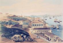
The old Harbour Master's
The old Harbour Master's House was till there in March 1860.
Photo was taken by Felice Beato
Harbour Master's House - other uses
Civil Hospital
1859:
As regards the prospective resources of the colony, a valuable piece of ground in the most frequented part of the city will be soon at the disposal of Government, and will, no doubt, produce a considerable sum of money. The purchase of the large house (as advised in my Despatch, No. 16, of 25th January last) for the new Civil Hospital will enable us to remove the mount called Pedder's Hill, on the top of which the present incommodious Civil Hospital stands ; the materials of the mount will be conveniently near to assist in recoveries from the sea and the formation of the Praya, and the removal of these materials will leave a large level spot as public property.
1859 - Assistant Magistrate Court
The history of the laws and courts of Hongkong - 1898
80skid this lot was sold in
80skid
this lot was sold in 1865 - so I think you can put that as a "demolish" date.
20th Century Impressions
To indieorientalis
You mentioned about "20th Century Impressions" Is it a book? Could you please advise where I can find it? I try to google it but too many returns....
Thanks
HF
Impressions
It's downloadable here:
http://www.archive.org/details/twentiethcentury00wriguoft
Book
Hey David,
You referenced in this post a book "Mapping Hong Kong." i was wondering if you could give me some more information on that book. I'm doing a project on hong kong and that sounds like a really useful resource.
My email address is mcv10@duke.edu if there's no mechanism to send the info over this site.
Thanks so much and hope to hear from you soon,
Marshall Vingi
Mapping Hong Kong
Hi Marshall,
It's a great resource, that I use a lot. Details here.
Regards, David