Just checked a street map and it reads 'Hop Yat Church/合一堂'. However the orientation of the modern day Hop Yat Church look different. I have no idea if it had ever been rebuilt, or the existing church had replaced another church whatsoever.
Further study of the map showed it shouldn't be the Hop Yat Church. The location of that church appears to be somewhere around the present day St. Stephen's Girls College Ellen Li Jubilee Building on Park Road, or lower. There is no church today around the few blocks there today, however.
We need some older maps for reference on this. I'll check the 1964 aerial photo book again tonight for this.
Yes, that's the book. It does not have full coverage, and the printed photos are a bit small. You would probably need a spy glass for scrutiny. At least it would give you some references of the period.
The Aerial photo of the location is on page 10-11 but at my approximation there was no church. Not even anything close. I look outwards from the curve of Park Road and nothing alike could be found. I guess we need a 1950's or even pre-war map to verify what church was that.
The highlighted area should be the extension of Tung Wah Hospital which was still under construction.
Moddsey:
Nice photo of Tai Ping Shan area and Possesion St. I think the former Marine Police HQ at TST can be seen which will put the date of the photo after 1884.
Page 59 of the 'City of Victoria' book has a photograph showing a similar view. It was taken later than the photo shown here, but their notes are still useful to us:
A view of the Tai Ping Shan District and Sheung Wan from Hospital Road, circa the 1880s. Clusters of buildings congested in the densely populated Chinese residential area. Po Yan Street, seen in the foreground, runs downslope and ends at its junction with Hollywood Road. The large piece of land seen close to the extreme left [just above the church] is the public square of Possession Point. Buildings of the Tung Wah Hospital are seen west of Po Yan Street, amongst them was Ping On House, the one with the arch verandahs [we just see its roof in rfrnt of the church in above photo]. Besides, a four storey building [the one under construction above] which was an extension of Tung Wah Hospital is also seen on the opposite side of the Street.
In the book's photo, the extension is already complete. So the above photo is an earlier view, so no later than the 1880s.
Looking at today's maps, there is a St Matthew's Church at about the same location as the one in the photo above. Here's their website. It's in Chinese, so I don't know if it gives any history of the church at that location.
I had a chat with Mr. cheung Po Hung (who is an author of several books about old photograph of Hong Kong). He said the church was St Matthew's Church. He also told me that the location of the Tung Wah Hospital expansion,which was under construction in the photo, was a cinema.The cinema was burnt in c1885. The Tung Wah Hospital then acquired that land and built the new hospital. so the date of this photo should be around 1887.
BTW, Mr Cheung is going to publish a new book in August and I promised to provide him a few images from my private collection, including this nice Tai Pan Shan photo.
The 'About us' section has a brief introduction. I am quoting the respectiver paragraph, then I will attemp to translate. Some phrases might be missing as I do not know the proper names.
The St. Matthew's Church is located in Hollywood Road, Sheung Wan, in the proximity of the Possession Street. It's back door is right opposite the Tung Wah Hospital. The church was first called 'Christian Mission Society' and was the foundation of one of the first Christian missions in town some one hundred and thirty years ago. The church was later renamed the St. Stephen's Church, and was removed. A school was built in tt's location together with another church 'The Holy Church of Jesus Christ' (this an approximation from the Chinese 「耶穌聖教堂」). The church was renamed to St. Matthew's Churce in 1949.
Strange enough, I am unable to find anything about this church in the SKH english site yet. Maybe it's the design of the SKH site. I'm just not familiar with it. Anyway.....
I think the small church shown on the photo is used to be S.K.H. St Mattew's Church on Hollywood Road, opposite a green open space, now called Hollywood Rd Park. It was demolished and built a primary school on the site there.
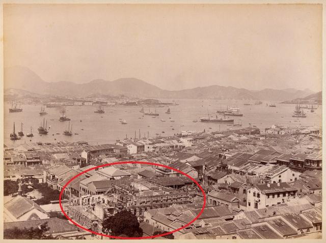
The building marked by a red circle is most likely Tung Wah Hospital,Sheung Wan
perhaps the 1870s map has the road where Hop Yat Church is on...I failed to locate a street address for the Hop Yat CHurch but the photo is kind of deceiving for it is sitting on a triangular plot of land supported by a castle type of stone wall with a stairways built along side for pedestrians to walk up to the hillside, to church!
Church of Christ in China is the same as Hop Yat Church. Headquarter was built on the hill side on Hong Kong side of the British Colony. Kowloon's Hop Yat Church was not complete until 1957 or so. And ther are more branches to serve the needs of the congregants living in different disctrict.
Comments
Church?
Just to the left of the red oval looks to be a small church with a cross on its roof. Any idea which church that was?
Re; Churgh
Hi there,
I think it's the church on Caine Road on a terrace between Seymour and Breezy. I have forgotten its name.
Best Regards,
T
Hop Yat Church
Hi there,
Just checked a street map and it reads 'Hop Yat Church/合一堂'. However the orientation of the modern day Hop Yat Church look different. I have no idea if it had ever been rebuilt, or the existing church had replaced another church whatsoever.
Does anybody have any other ideas?
Best Regards,
T
OK, it was not Hop Yat Church
Hi there,
Further study of the map showed it shouldn't be the Hop Yat Church. The location of that church appears to be somewhere around the present day St. Stephen's Girls College Ellen Li Jubilee Building on Park Road, or lower. There is no church today around the few blocks there today, however.
We need some older maps for reference on this. I'll check the 1964 aerial photo book again tonight for this.
Best Regards,
T
1964 aerial photo book ?
"Hong Kong in Old Times - A Collection of Aerial Photos Taken in 1964"
click here
Re: 1964 Aerial Photo Book,
Hi there,
Yes, that's the book. It does not have full coverage, and the printed photos are a bit small. You would probably need a spy glass for scrutiny. At least it would give you some references of the period.
Best Regards,
T
Aerial Photo checked...... no church there back in early 1960's
Hi there,
The Aerial photo of the location is on page 10-11 but at my approximation there was no church. Not even anything close. I look outwards from the curve of Park Road and nothing alike could be found. I guess we need a 1950's or even pre-war map to verify what church was that.
Best Regards,
T
Notes on photo
HF Siu:
Can someone advise the date of this photo?
The highlighted area should be the extension of Tung Wah Hospital which was still under construction.
Moddsey:
Nice photo of Tai Ping Shan area and Possesion St. I think the former Marine Police HQ at TST can be seen which will put the date of the photo after 1884.
re: Sheung Wan
Page 59 of the 'City of Victoria' book has a photograph showing a similar view. It was taken later than the photo shown here, but their notes are still useful to us:
A view of the Tai Ping Shan District and Sheung Wan from Hospital Road, circa the 1880s. Clusters of buildings congested in the densely populated Chinese residential area. Po Yan Street, seen in the foreground, runs downslope and ends at its junction with Hollywood Road. The large piece of land seen close to the extreme left [just above the church] is the public square of Possession Point. Buildings of the Tung Wah Hospital are seen west of Po Yan Street, amongst them was Ping On House, the one with the arch verandahs [we just see its roof in rfrnt of the church in above photo]. Besides, a four storey building [the one under construction above] which was an extension of Tung Wah Hospital is also seen on the opposite side of the Street.
In the book's photo, the extension is already complete. So the above photo is an earlier view, so no later than the 1880s.
Looking at today's maps, there is a St Matthew's Church at about the same location as the one in the photo above. Here's their website. It's in Chinese, so I don't know if it gives any history of the church at that location.
I had a chat with Mr. cheung
I had a chat with Mr. cheung Po Hung (who is an author of several books about old photograph of Hong Kong). He said the church was St Matthew's Church. He also told me that the location of the Tung Wah Hospital expansion,which was under construction in the photo, was a cinema.The cinema was burnt in c1885. The Tung Wah Hospital then acquired that land and built the new hospital. so the date of this photo should be around 1887.
BTW, Mr Cheung is going to publish a new book in August and I promised to provide him a few images from my private collection, including this nice Tai Pan Shan photo.
re: I had a chat with Mr. cheung
Thanks for clarifying the church. I'll look forward to seeing Mr Cheng's next book.
Regards, David
Re: Chinese Website of St. Matthew's Church
Hi there,
The 'About us' section has a brief introduction. I am quoting the respectiver paragraph, then I will attemp to translate. Some phrases might be missing as I do not know the proper names.
Quote>>
聖馬太堂座落於上環荷李活道,鄰近水坑口街,後門為東華醫院。聖馬太堂原為「英國海外傳道會」(Christian Mission Society)在一百三十多年前為香港第一個傳道基址。後改名聖士提反堂,於一八八八年搬遷。原址辦學校及「耶穌聖教堂」。戰後1949年改名為聖馬太堂。
End Quote>>
The St. Matthew's Church is located in Hollywood Road, Sheung Wan, in the proximity of the Possession Street. It's back door is right opposite the Tung Wah Hospital. The church was first called 'Christian Mission Society' and was the foundation of one of the first Christian missions in town some one hundred and thirty years ago. The church was later renamed the St. Stephen's Church, and was removed. A school was built in tt's location together with another church 'The Holy Church of Jesus Christ' (this an approximation from the Chinese 「耶穌聖教堂」). The church was renamed to St. Matthew's Churce in 1949.
Strange enough, I am unable to find anything about this church in the SKH english site yet. Maybe it's the design of the SKH site. I'm just not familiar with it. Anyway.....
Hope this helps a bit.
T
Re: Chinese Website of St. Matthew's Church
Thanks Thomas. After reading your translation, it looks as though the church in the photo above was St Stephen's Church.
Hi,
Hi,
I think the small church shown on the photo is used to be S.K.H. St Mattew's Church on Hollywood Road, opposite a green open space, now called Hollywood Rd Park. It was demolished and built a primary school on the site there.
The building marked by a red circle is most likely Tung Wah Hospital,Sheung Wan
Hop Yat Church 'live" stream....
Hop Yat Church had been at a hillside into 171 years of continue service https://www.youtube.com/live/pkQqTBuNG4M?feature=share
perhaps the 1870s map has the road where Hop Yat Church is on...I failed to locate a street address for the Hop Yat CHurch but the photo is kind of deceiving for it is sitting on a triangular plot of land supported by a castle type of stone wall with a stairways built along side for pedestrians to walk up to the hillside, to church!
Church of Christ in China
Church of Christ in China is the same as Hop Yat Church. Headquarter was built on the hill side on Hong Kong side of the British Colony. Kowloon's Hop Yat Church was not complete until 1957 or so. And ther are more branches to serve the needs of the congregants living in different disctrict.