Not sure of the exact date. Just going by the street lighting and indication of the lettering 'Kowloon Tong' in the photo.
(2023 Update - Revisited the main photo, I have amended the decade from the 1950s to the 1930s as the houses appear to be newly built. Still no clue of their location.)
Date picture taken
1930s
Gallery
Shows place(s)
Comments
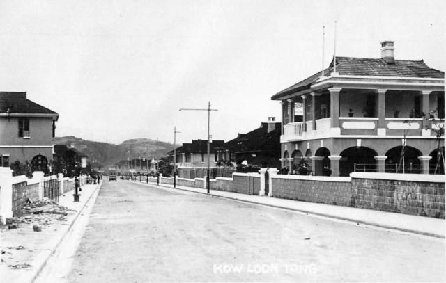
Stafford Road?
The low hills at the back mean this isn't a north facing view, so it has to be east, west or south facing. Also it looks as though there is a T-junction at the end where it intersects with another road.
I don't think this is east facing because that would mean the junction is with Waterloo Road and the houses at the far end (i.e. they would be on the opposite side of Waterloo Road) were not the same type/style of house.
If it's west facing it can only be Somerset, York or Lincoln Roads, but I don't think any fit the bill: there's no turning for Devon Rd on the right so it can't be Somerset, the houses at the far end indicate it can't be York (no houses were ever built there as far as I know) and I don't think it's Lincoln because that would mean there was a hill where Fa Hui Park is now (was there?)
So perhaps this is south facing and the hill at the far end is the northern side of Kadoorie Hill. This would mean only one of three roads: Kent, Stafford or Cumberland. The T-junction at the end (assuming it is one) makes me think this is Stafford Road because neither Kent nor Cumberland have a junction like that (plus Kent's angle points it away from Kadoorie Hill). But if this is Stafford then the photo must be earlier because I don't see any development on Kadoorie Hill yet...
This is a challenge
I agree with you on those points...had thought they might be the hills where City University now stands but as you say, there were probably no houses at the very western end of York Rd. Also seems like the road is sloping gently downhill, though admittedly it's hard to tell for sure. I'm no closer to figuring it out yet!
One more thing
Also, the fact that it looks to be such a long road weighs in favour of Stafford or (less likely) Cumberland - all the others in KTGE are too short.
Downhill
I think this road slopes downhill, judging by the steps in the height of the garden walls.
Regards, David
Some kind of white monument?
It's hard to make out, but is there some kind of tallish white monument with dome on top, on the right in the background, just before what looks like a junction?
Looking down Cumberland Rd from Rutland end?
If you look at the stepped stone wall on the near left of the photo, it's possibly comparable (and this is a long shot) with the stepped wall in the photo already on Gwulo that shows the bus turning at the junction of Cumberland & Rutland (sorry, I don't know how to insert that photo here, but will have a go so it's easier to compare).
Photo for comparison
David, I'm not having any luck trying to upload the photo here ("Junction of Cumberland Road and Rutland Quadrant" from the "1930s Kowloon Tong" gallery) - have tried the correct procedure but nothing happens when I click on 'insert' - is it because I'm using an iPad maybe?
Maybe far-fetched...
But I'm even thinking - if this 1950s photo was taken at the Cumberland/Rutland junction - that the earlier (1930s) photo, taken at the same place but looking in the opposite direction, may actually have been taken from the side veranda of the big house - if it had already been added on by the 1930s.
Cumberland/Rutland junction
Here's the photo:
I don't see anything that gives us a 100% match, but it's certainly possible. We need a few more old photos of the area to confirm.
Regards, David
PS I'm not sure about the iPad problem, but will be spending time on this area of the website in the next few weeks and will take a closer look then.