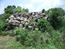
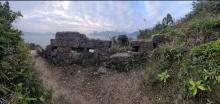
Everything tagged: Imperial Chinese Military Sites

Photos tagged: Imperial Chinese Military Sites

2013
????
????

Pages tagged: Imperial Chinese Military Sites

Sacred Hill (Castle Peak) Beacon 聖山墩臺 [????- ]

Submitted by tngan on Thu, 06/06/2013 - 01:44

The marker is marked based on the GPS coordinates of the Trigoman's Castle Peak 517m Trigo Station.  If there are errors they are entirely mine.   Thanks should be made to JW and his gang for the location and theory of this site, together with the Shek Lung Kung site.

The location is documented in 新安縣誌﹐ and some other documents.  The discussions of JW and his gang concerning this Beacon and others could be located here.   The discussions are generally in Chinese.

Beacon - Dawan (大灣墩臺) Possible location [????- ]

Submitted by tngan on Thu, 04/26/2012 - 01:27

The location is a pure speculation based on the descriptions of the list of Beacons in the Peng Cheng Museum 鵬城博物館.  Would gladly be corrected by knowledgeable persons already been there.   This possible location is marked based on the description saying it is around 1.5 km from Da Peng Walled City.  It also mentioned it is one of the better preserved beacons.

Beacon - Defu (疊福墩臺) possible location [????- ]

Submitted by tngan on Thu, 04/26/2012 - 00:55

The location is a pure speculation based on the descriptions of the list of Beacons in the Peng Cheng Museum 鵬城博物館.  Would gladly be corrected by knowledgeable persons already been there.  I believe the location is possible because from Google Earth there appeared to be traces of a very wide path laid by big rocks right at a spur around 250m, overlooking Mirs Bay, just as what's been described by the Peng Cheng Museum.  It also mentioned the said beacon was in retangular shape, built by stones.

Beacon - Ma Jerk Leng (麻雀嶺墩臺) Wo Keng Shan summit (禾徑山) [????- ]

Submitted by tngan on Sat, 04/14/2012 - 03:20

Location is approximate.  Will update the market if I have the chance for a site visit.  Google Earth showed a clear path upon its NE ridge.  As for the time being there are some photos and information in Chinese in Hong Kong Hiking Web, provided by JW and other fellow hikers.

Beacon - North Fat Tong (北佛堂墩臺) Tin Ha Shan (田下山) [????- ]

Submitted by tngan on Fri, 04/13/2012 - 18:00

The location is approximate.  I will update the marker once I have visited it myself later, probably in May.  According to JW and other fellow hikers the trigonomatrical station was built right on top of the beacon, covering most of it.  Photos could be see under this link.